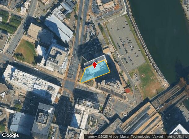
Property Record
826 Mccarter Hwy, Newark, NJ 07102


Current Lease Availabilities
NEARBY LISTINGS FOR SALE OR LEASE
-
-
-
-
No Photo
-
-
-
-
View all Newark listings for lease on LoopNet.com
Property Detail
826 Mccarter Hwy
Newark, NJ-PA
32612 SF .7487
14-00136-0000-00063-02
Essex
Vacantlandnec
New Jersey
X
63.2
34013C0156F
0.75 AC
2023
Newark
2025
Northern New Jersey
008100
DEMOGRAPHICS near 826 Mccarter Hwy
1 Mile
3 Mile
5 Mile
2024 Total Population
58,081
318,095
773,316
2029 Population
56,509
306,473
746,298
Pop Growth 2024-2029
(2.71%)
(3.65%)
(3.49%)
Average Age
37
36
38
2024 Total Households
23,759
114,290
282,257
HH Growth 2024-2029
(2.41%)
(3.70%)
(3.63%)
Median Household Inc
$53,507
$45,837
$55,734
Avg Household Size
2.30
2.60
2.60
2024 Avg HH Vehicles
1.00
1.00
1.00
Median Home Value
$409,307
$326,657
$342,116
Median Year Built
1978
1967
1958
Nearby Places
Map Layers
Map Styles
 Street
 Aerial
- Restaurants
- Banks
- Shops
- Fitness
- Groceries
PUBLIC TRANSPORTATION
TRANSIT/SUBWAY
NJPAC/Center Street (Broad Street Station - Newark Penn Station - Newark Light Rail (Newark Light Rail))
DRIVE
WALK
Distance
NJPAC/Center Street (Broad Street Station - Newark Penn Station - Newark Light Rail (Newark Light Rail))
2 min
6 min
0.3 mi
Military Park (Grove Street - Newark Penn Station - Newark Light Rail (Newark Light Rail))
DRIVE
WALK
Distance
Military Park (Grove Street - Newark Penn Station - Newark Light Rail (Newark Light Rail))
1 min
10 min
0.4 mi
Newark Penn Station (Newark Penn Station-World Trade Center - Port Authority Trans-Hudson (PATH))
DRIVE
WALK
Distance
Newark Penn Station (Newark Penn Station-World Trade Center - Port Authority Trans-Hudson (PATH))
1 min
14 min
0.5 mi
COMMUTER RAIL
Newark Penn Station (Newark Penn Station-World Trade Center - Port Authority Trans-Hudson (PATH))
DRIVE
WALK
Distance
Newark Penn Station (Newark Penn Station-World Trade Center - Port Authority Trans-Hudson (PATH))
1 min
14 min
0.5 mi
Newark Broad Street (Montclair-Boonton Line - NJ Transit Commuter Rail (NJ Transit), Morris & Essex Gladstone Branch - NJ Transit Commuter Rail (NJ Transit), Morris & Essex Morristown Line - NJ Transit Commuter Rail (NJ Transit))
DRIVE
WALK
Distance
Newark Broad Street (Montclair-Boonton Line - NJ Transit Commuter Rail (NJ Transit), Morris & Essex Gladstone Branch - NJ Transit Commuter Rail (NJ Transit), Morris & Essex Morristown Line - NJ Transit Commuter Rail (NJ Transit))
4 min
20 min
1.0 mi
AIRPORT
Newark Liberty International
DRIVE
WALK
Distance
Newark Liberty International
10 min
4.7 mi
LaGuardia
DRIVE
WALK
Distance
LaGuardia
41 min
22.2 mi
John F Kennedy International
DRIVE
WALK
Distance
John F Kennedy International
50 min
30.2 mi
Freight Ports
Maher Terminal
DRIVE
WALK
Distance
Maher Terminal
14 min
5.5 mi
Nearby Properties
Address
Land Use
TOTAL SIZE
Lot Size
Zoning
Address
Land Use
TOTAL SIZE
Lot Size
Zoning
0.57 AC
Address
Land Use
TOTAL SIZE
Lot Size
Zoning
0.45 AC
Address
Land Use
TOTAL SIZE
Lot Size
Zoning
Address
Land Use
TOTAL SIZE
Lot Size
Zoning
31.86 AC
Address
Land Use
TOTAL SIZE
Lot Size
Zoning
25.69 AC
Address
Land Use
TOTAL SIZE
Lot Size
Zoning
Address
Land Use
TOTAL SIZE
Lot Size
Zoning
98.48 AC
Address
Land Use
TOTAL SIZE
Lot Size
Zoning
877 SF
7.25 AC
Address
Land Use
TOTAL SIZE
Lot Size
Zoning
4.51 AC
Address
Land Use
TOTAL SIZE
Lot Size
Zoning
683 SF
9.59 AC
Address
Land Use
TOTAL SIZE
Lot Size
Zoning
2.01 AC
Address
Land Use
TOTAL SIZE
Lot Size
Zoning
3.42 AC
Address
Land Use
TOTAL SIZE
Lot Size
Zoning
320 SF
1.25 AC
Address
Land Use
TOTAL SIZE
Lot Size
Zoning
710 SF
39.32 AC
Address
Land Use
TOTAL SIZE
Lot Size
Zoning
9.77 AC
Address
Land Use
TOTAL SIZE
Lot Size
Zoning
877 SF
0.91 AC
Address
Land Use
TOTAL SIZE
Lot Size
Zoning
1.64 AC
Address
Land Use
TOTAL SIZE
Lot Size
Zoning
Address
Land Use
TOTAL SIZE
Lot Size
Zoning
1.63 AC
Address
Land Use
TOTAL SIZE
Lot Size
Zoning
Address
Land Use
TOTAL SIZE
Lot Size
Zoning
2.79 AC
Address
Land Use
TOTAL SIZE
Lot Size
Zoning
4.82 AC
Address
Land Use
TOTAL SIZE
Lot Size
Zoning
0.13 AC
Address
Land Use
TOTAL SIZE
Lot Size
Zoning
1,264 SF
3.20 AC
Address
Land Use
TOTAL SIZE
Lot Size
Zoning
Address
Land Use
TOTAL SIZE
Lot Size
Zoning
0.06 AC
Address
Land Use
TOTAL SIZE
Lot Size
Zoning
0.09 AC
Address
Land Use
TOTAL SIZE
Lot Size
Zoning
877 SF
1.95 AC
Address
Land Use
TOTAL SIZE
Lot Size
Zoning
877 SF
1.35 AC
Address
Land Use
TOTAL SIZE
Lot Size
Zoning
683 SF
0.79 AC
The World's #1 Commercial Real Estate Marketplace
Connect with us
© 2025 CoStar Group
The information above has been obtained from sources believed reliable. While we do not doubt its accuracy we have not verified it and make no guarantee, warranty or representation about it. It is your responsibility to independently confirm its accuracy and completeness. Any projections, opinions, assumptions, or estimates used are for example only and do not represent the current or future performance of the property. The value of this transaction to you depends on tax and other factors which should be evaluated by your tax, financial, and legal advisors. You and your advisors should conduct a careful, independent investigation of the property to determine to your satisfaction the suitability of the property for your needs.