Property Record
2 S Park Rd Sw, Birmingham, AL 35211
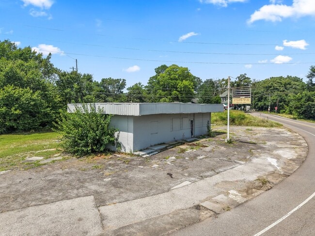
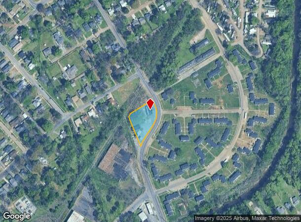
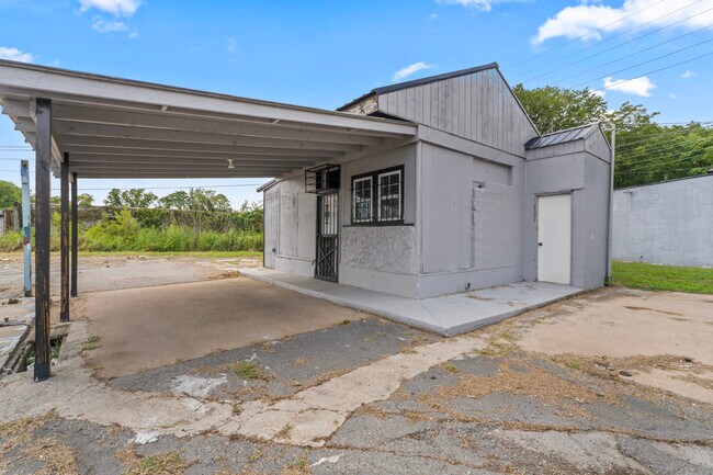
This Property Is For Sale
NEARBY LISTINGS FOR SALE OR LEASE
Property Detail
2 S Park Rd Sw
29-00-08-2-032-002.000
POB 90 FT S SE OF THE INTER OF THE SW LINE OF AVE U & THE SE RR OF SCL RR TH SLY 335 FT S ALG AVE U TO SO PK RD TH NW 215 FT S ALG SO PK RD TO RR R/W TH NLY 10 FT S ALG RR TO ALLEY TH NE 180 FT S ALG ALLEY TO POB LYING IN NW 1/4 SEC 8 TP 18 R3W
Restaurantbuilding
Jefferson
X
Alabama
01073C0532G
0.62 AC
2023
Bessemer
2024
Birmingham
003803
Birmingham-Hoover, AL
2,995 SF
DEMOGRAPHICS near 2 S Park Rd Sw
1 Mile
3 Mile
5 Mile
2024 Total Population
12,383
74,512
153,851
2029 Population
12,667
76,223
155,708
Pop Growth 2024-2029
+ 2.29%
+ 2.30%
+ 1.21%
Average Age
42
41
39
2024 Total Households
5,283
32,132
66,404
HH Growth 2024-2029
+ 2.31%
+ 2.37%
+ 1.22%
Median Household Inc
$40,121
$38,957
$46,091
Avg Household Size
2.30
2.20
2.10
2024 Avg HH Vehicles
2.00
1.00
2.00
Median Home Value
$62,214
$85,586
$133,343
Median Year Built
1958
1960
1966
Nearby Places
- Restaurants
- Banks
- Shops
- Fitness
- Groceries
PUBLIC TRANSPORTATION
COMMUTER RAIL
Birmingham (Crescent - Amtrak)
DRIVE
WALK
Distance
Birmingham (Crescent - Amtrak)
9 min
5.3 mi
AIRPORT
Birmingham-Shuttlesworth International
DRIVE
WALK
Distance
Birmingham-Shuttlesworth International
17 min
10.4 mi
Freight Ports
Port of Mobile
DRIVE
WALK
Distance
Port of Mobile
284 min
256.8 mi
Nearby Properties
Address
Land Use
TOTAL SIZE
Lot Size
Zoning
Address
Land Use
TOTAL SIZE
Lot Size
Zoning
203,878 SF
12.58 AC
B6
Address
Land Use
TOTAL SIZE
Lot Size
Zoning
344,150 SF
42 AC
R5
Address
Land Use
TOTAL SIZE
Lot Size
Zoning
416,477 SF
80 AC
R5
Address
Land Use
TOTAL SIZE
Lot Size
Zoning
311,982 SF
30 AC
R6
Address
Land Use
TOTAL SIZE
Lot Size
Zoning
180,412 SF
14.89 AC
R6
Address
Land Use
TOTAL SIZE
Lot Size
Zoning
1.77 AC
QO&I
Address
Land Use
TOTAL SIZE
Lot Size
Zoning
267,289 SF
18.40 AC
L1
Address
Land Use
TOTAL SIZE
Lot Size
Zoning
146,358 SF
13.70 AC
R6
Address
Land Use
TOTAL SIZE
Lot Size
Zoning
127,240 SF
3.50 AC
R4
Address
Land Use
TOTAL SIZE
Lot Size
Zoning
200,650 SF
19.48 AC
R4
Address
Land Use
TOTAL SIZE
Lot Size
Zoning
198,732 SF
11.60 AC
L1
Address
Land Use
TOTAL SIZE
Lot Size
Zoning
336,653 SF
22.50 AC
CM1
Address
Land Use
TOTAL SIZE
Lot Size
Zoning
106,366 SF
8.70 AC
R3
Address
Land Use
TOTAL SIZE
Lot Size
Zoning
98,932 SF
11 AC
R5
Address
Land Use
TOTAL SIZE
Lot Size
Zoning
68,046 SF
6 AC
B6
Address
Land Use
TOTAL SIZE
Lot Size
Zoning
83,583 SF
10.61 AC
R5
Address
Land Use
TOTAL SIZE
Lot Size
Zoning
250,918 SF
10 AC
B-2
Address
Land Use
TOTAL SIZE
Lot Size
Zoning
65,299 SF
2 AC
B2
Address
Land Use
TOTAL SIZE
Lot Size
Zoning
101,302 SF
8.10 AC
C5
Address
Land Use
TOTAL SIZE
Lot Size
Zoning
46,155 SF
0.77 AC
R4
Address
Land Use
TOTAL SIZE
Lot Size
Zoning
93,081 SF
1.06 AC
B2
Address
Land Use
TOTAL SIZE
Lot Size
Zoning
1.83 AC
B6
Address
Land Use
TOTAL SIZE
Lot Size
Zoning
225,942 SF
7.30 AC
M1
Address
Land Use
TOTAL SIZE
Lot Size
Zoning
41,695 SF
5.40 AC
R4
Address
Land Use
TOTAL SIZE
Lot Size
Zoning
101,671 SF
14.73 AC
B2
Address
Land Use
TOTAL SIZE
Lot Size
Zoning
74,509 SF
9 AC
B6
Address
Land Use
TOTAL SIZE
Lot Size
Zoning
211,517 SF
9.50 AC
M1
Address
Land Use
TOTAL SIZE
Lot Size
Zoning
140,764 SF
7.21 AC
R6
Address
Land Use
TOTAL SIZE
Lot Size
Zoning
37,619 SF
9.36 AC
R3
Address
Land Use
TOTAL SIZE
Lot Size
Zoning
29,781 SF
3.44 AC
C3
The World's #1 Commercial Real Estate Marketplace
Connect with us
© 2025 CoStar Group
The information above has been obtained from sources believed reliable. While we do not doubt its accuracy we have not verified it and make no guarantee, warranty or representation about it. It is your responsibility to independently confirm its accuracy and completeness. Any projections, opinions, assumptions, or estimates used are for example only and do not represent the current or future performance of the property. The value of this transaction to you depends on tax and other factors which should be evaluated by your tax, financial, and legal advisors. You and your advisors should conduct a careful, independent investigation of the property to determine to your satisfaction the suitability of the property for your needs.