Property Record
2 Sconticut Neck Rd, Fairhaven, MA 02719
Save to a Folder
{{folder.Name}}
{{folder.ListingIds.length}} Properties
{{folder.ListingIds.length}} Property
Create a New Folder
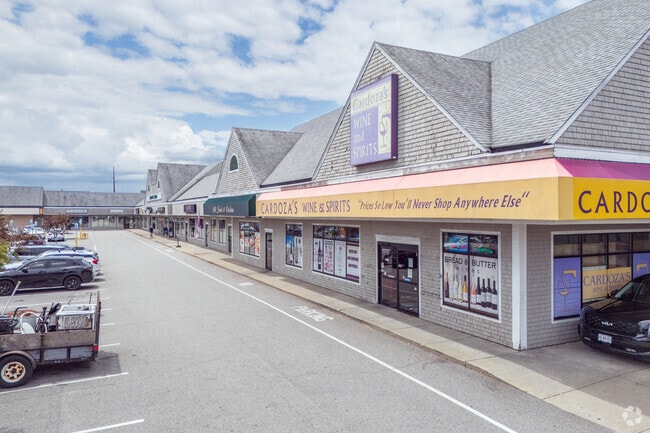
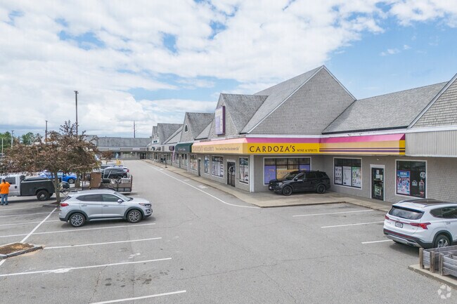
Property Detail
2 Sconticut Neck Rd
FAIR-000028-000000-000022
BRISTOL
Regionalshoppingcenterormallwithanchorstore
Massachusetts
B
37
B and X Area of moderate flood hazard, usually the area between the limits of the 100-year and 500-year floods.
4.22 AC
2025
Attleboro/New Bedford
2025
Boston
655400
Providence-Warwick, RI-MA
51,892 SF
NEARBY LISTINGS FOR SALE OR LEASE
DEMOGRAPHICS near 2 Sconticut Neck Rd
1 mile
3 mile
5 mile
2025 Total Population
4,693
65,272
127,388
2030 Population
4,790
65,155
127,713
Pop Growth 2025-2030
+ 2.07%
(0.18%)
+ 0.26%
Average Age
46
40
42
2025 Total Households
1,945
27,308
53,166
HH Growth 2025-2030
+ 2.16%
(0.11%)
+ 0.34%
Median Household Inc
$90,766
$54,608
$64,302
Avg Household Size
2.40
2.30
2.30
2025 Avg HH Vehicles
2.00
1.00
2.00
Median Home Value
$449,276
$396,231
$405,263
Median Year Built
1952
1947
1949
Nearby Places
Map Layers
Map Styles
 Street
 Aerial
Layers
 Traffic
 Biking
Places
Listings with unknown addresses are not visible on the map
- Restaurants
- Banks
- Shops
- Fitness
- Groceries
PUBLIC TRANSPORTATION
AIRPORT
Rhode Island Tf Green International
Drive
Walk
Distance
Rhode Island Tf Green International
52 min
41.7 mi
Barnstable Municipal-Boardman-Polando Field
Drive
Walk
Distance
Barnstable Municipal-Boardman-Polando Field
59 min
45.1 mi
SALE & LEASE HISTORY
LISTING DATE
SALE/LEASE

Sep 24, 2016
For Lease
Sep 24, 2016
For Lease
Nearby Properties
Address
Land Use
TOTAL SIZE
Lot Size
Zoning
Address
Land Use
TOTAL SIZE
Lot Size
Zoning
228,726 SF
5.51 AC
MUB
Address
Land Use
TOTAL SIZE
Lot Size
Zoning
61.86 AC
I
Address
Land Use
TOTAL SIZE
Lot Size
Zoning
269,020 SF
2.26 AC
MUB
Address
Land Use
TOTAL SIZE
Lot Size
Zoning
231,634 SF
2.45 AC
IB
Address
Land Use
TOTAL SIZE
Lot Size
Zoning
160,391 SF
2.86 AC
MUB
Address
Land Use
TOTAL SIZE
Lot Size
Zoning
27.48 AC
B
Address
Land Use
TOTAL SIZE
Lot Size
Zoning
214,698 SF
4.66 AC
IB
Address
Land Use
TOTAL SIZE
Lot Size
Zoning
127,514 SF
4.23 AC
MUB
Address
Land Use
TOTAL SIZE
Lot Size
Zoning
188,739 SF
2.57 AC
IB
Address
Land Use
TOTAL SIZE
Lot Size
Zoning
5.59 AC
RC
Address
Land Use
TOTAL SIZE
Lot Size
Zoning
183,450 SF
2.51 AC
RA
Address
Land Use
TOTAL SIZE
Lot Size
Zoning
183,196 SF
8.14 AC
MUB
Address
Land Use
TOTAL SIZE
Lot Size
Zoning
146,081 SF
2.15 AC
MUB
Address
Land Use
TOTAL SIZE
Lot Size
Zoning
147,850 SF
2.50 AC
RC
Address
Land Use
TOTAL SIZE
Lot Size
Zoning
119,865 SF
3.22 AC
IA
Address
Land Use
TOTAL SIZE
Lot Size
Zoning
73,520 SF
18.44 AC
R45
Address
Land Use
TOTAL SIZE
Lot Size
Zoning
212,875 SF
7.24 AC
WI
Address
Land Use
TOTAL SIZE
Lot Size
Zoning
11.11 AC
B
Address
Land Use
TOTAL SIZE
Lot Size
Zoning
116,158 SF
3.80 AC
IB
Address
Land Use
TOTAL SIZE
Lot Size
Zoning
2,190 SF
9.73 AC
IA
Address
Land Use
TOTAL SIZE
Lot Size
Zoning
8.69 AC
RA
Address
Land Use
TOTAL SIZE
Lot Size
Zoning
91,660 SF
1.26 AC
MUB
Address
Land Use
TOTAL SIZE
Lot Size
Zoning
3.15 AC
RA
Address
Land Use
TOTAL SIZE
Lot Size
Zoning
101,289 SF
1.98 AC
RC
Address
Land Use
TOTAL SIZE
Lot Size
Zoning
128,298 SF
1.99 AC
MUB
Address
Land Use
TOTAL SIZE
Lot Size
Zoning
74,409 SF
9.40 AC
B
Address
Land Use
TOTAL SIZE
Lot Size
Zoning
5.30 AC
RC
Address
Land Use
TOTAL SIZE
Lot Size
Zoning
20.70 AC
I
Address
Land Use
TOTAL SIZE
Lot Size
Zoning
40,446 SF
4.36 AC
WI
Address
Land Use
TOTAL SIZE
Lot Size
Zoning
381.39 AC
The World's #1 Commercial Real Estate Marketplace
Connect with us
© 2026 CoStar Group
The information above has been obtained from sources believed reliable. While we do not doubt its accuracy we have not verified it and make no guarantee, warranty or representation about it. It is your responsibility to independently confirm its accuracy and completeness. Any projections, opinions, assumptions, or estimates used are for example only and do not represent the current or future performance of the property. The value of this transaction to you depends on tax and other factors which should be evaluated by your tax, financial, and legal advisors. You and your advisors should conduct a careful, independent investigation of the property to determine to your satisfaction the suitability of the property for your needs.