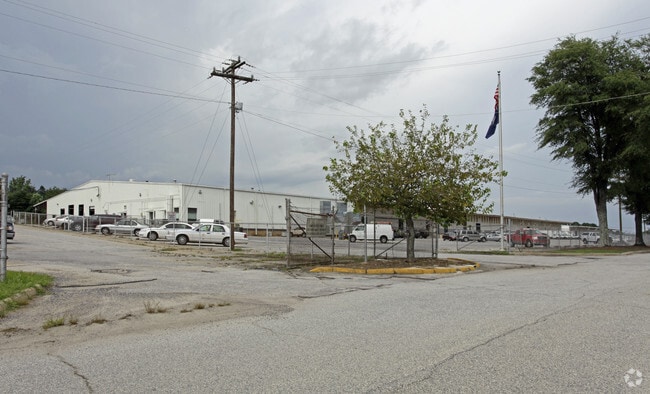
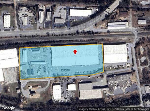
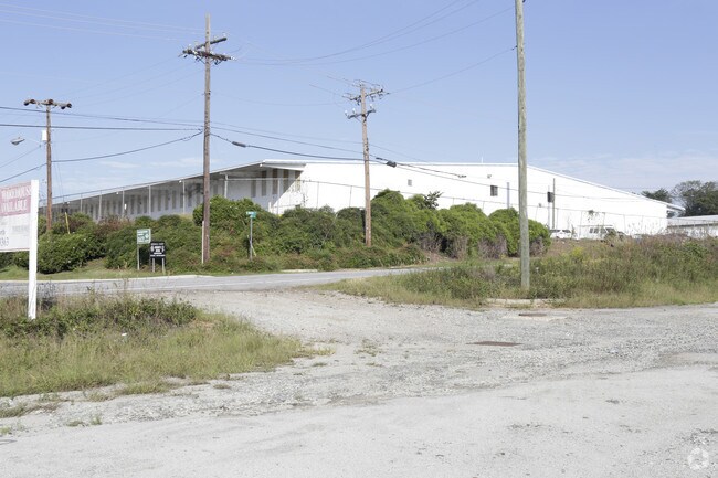
Property Record
2 Space Dr, Taylors, SC 29687
NEARBY LISTINGS FOR SALE OR LEASE
Property Detail
2 Space Dr
Greenville-Anderson-Mauldin, SC
WAREHOUSE (DIST CTR )
T030.00-05-001.11
Greenville
Uspostalservice
South Carolina
X
001.11
45045C0337E
10 AC
0
Rt 29 Rutherford Rd
2024
Greenville/Spartanburg
001700
DEMOGRAPHICS near 2 Space Dr
1 Mile
3 Mile
5 Mile
2024 Total Population
5,966
54,095
135,112
2029 Population
6,514
59,205
148,264
Pop Growth 2024-2029
+ 9.19%
+ 9.45%
+ 9.73%
Average Age
41
40
40
2024 Total Households
2,446
21,948
55,488
HH Growth 2024-2029
+ 9.28%
+ 9.52%
+ 9.89%
Median Household Inc
$60,095
$66,923
$69,638
Avg Household Size
2.40
2.40
2.30
2024 Avg HH Vehicles
2.00
2.00
2.00
Median Home Value
$187,406
$241,362
$266,471
Median Year Built
1975
1979
1984
Nearby Places
Map Layers
Map Styles
 Street
 Aerial
- Restaurants
- Banks
- Shops
- Fitness
- Groceries
PUBLIC TRANSPORTATION
COMMUTER RAIL
DRIVE
WALK
Distance
15 min
6.9 mi
AIRPORT
Greenville Spartanburg International
DRIVE
WALK
Distance
Greenville Spartanburg International
17 min
9.1 mi
Nearby Properties
Address
Land Use
TOTAL SIZE
Lot Size
Zoning
Address
Land Use
TOTAL SIZE
Lot Size
Zoning
11.80 AC
R10
Address
Land Use
TOTAL SIZE
Lot Size
Zoning
11.30 AC
R10
Address
Land Use
TOTAL SIZE
Lot Size
Zoning
4.95 AC
C1
Address
Land Use
TOTAL SIZE
Lot Size
Zoning
8.98 AC
C1
Address
Land Use
TOTAL SIZE
Lot Size
Zoning
8.95 AC
OD
Address
Land Use
TOTAL SIZE
Lot Size
Zoning
26.30 AC
R20
Address
Land Use
TOTAL SIZE
Lot Size
Zoning
85.24 AC
C2,R12
Address
Land Use
TOTAL SIZE
Lot Size
Zoning
41.90 AC
RMA
Address
Land Use
TOTAL SIZE
Lot Size
Zoning
3.40 AC
C2
Address
Land Use
TOTAL SIZE
Lot Size
Zoning
58.81 AC
R15
Address
Land Use
TOTAL SIZE
Lot Size
Zoning
15.83 AC
RM
Address
Land Use
TOTAL SIZE
Lot Size
Zoning
3.50 AC
C2
Address
Land Use
TOTAL SIZE
Lot Size
Zoning
1.20 AC
I1
Address
Land Use
TOTAL SIZE
Lot Size
Zoning
3.70 AC
C2
Address
Land Use
TOTAL SIZE
Lot Size
Zoning
16.40 AC
PDC
Address
Land Use
TOTAL SIZE
Lot Size
Zoning
8.10 AC
I1
Address
Land Use
TOTAL SIZE
Lot Size
Zoning
21.65 AC
RM7
Address
Land Use
TOTAL SIZE
Lot Size
Zoning
6.10 AC
C2
Address
Land Use
TOTAL SIZE
Lot Size
Zoning
1.03 AC
RM
Address
Land Use
TOTAL SIZE
Lot Size
Zoning
14.78 AC
I1
Address
Land Use
TOTAL SIZE
Lot Size
Zoning
5.21 AC
C2
Address
Land Use
TOTAL SIZE
Lot Size
Zoning
9.14 AC
R75
Address
Land Use
TOTAL SIZE
Lot Size
Zoning
3.11 AC
I1
Address
Land Use
TOTAL SIZE
Lot Size
Zoning
11.30 AC
R20
Address
Land Use
TOTAL SIZE
Lot Size
Zoning
12 AC
RM
Address
Land Use
TOTAL SIZE
Lot Size
Zoning
12.30 AC
I1
Address
Land Use
TOTAL SIZE
Lot Size
Zoning
2,323 SF
23.11 AC
R20
Address
Land Use
TOTAL SIZE
Lot Size
Zoning
11.90 AC
R12
Address
Land Use
TOTAL SIZE
Lot Size
Zoning
1.70 AC
R75
Address
Land Use
TOTAL SIZE
Lot Size
Zoning
9.17 AC
RM
The World's #1 Commercial Real Estate Marketplace
Connect with us
© 2025 CoStar Group
The information above has been obtained from sources believed reliable. While we do not doubt its accuracy we have not verified it and make no guarantee, warranty or representation about it. It is your responsibility to independently confirm its accuracy and completeness. Any projections, opinions, assumptions, or estimates used are for example only and do not represent the current or future performance of the property. The value of this transaction to you depends on tax and other factors which should be evaluated by your tax, financial, and legal advisors. You and your advisors should conduct a careful, independent investigation of the property to determine to your satisfaction the suitability of the property for your needs.