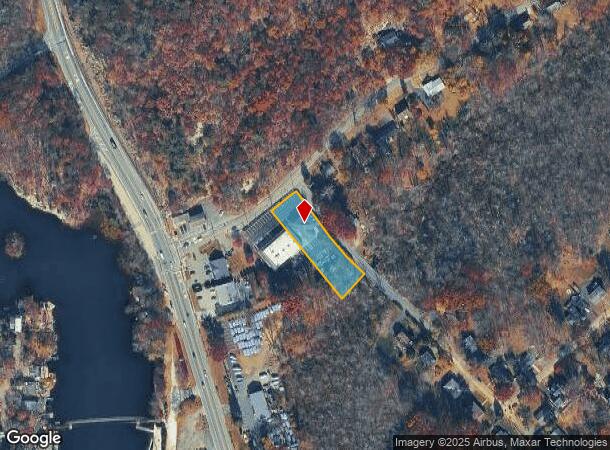
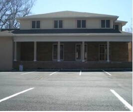
Property Record
2 Tamarack Rd, Byram Township, NJ 07821

NEARBY LISTINGS FOR SALE OR LEASE
-
-
View all Byram Township listings for lease on LoopNet.com
Property Detail
2 Tamarack Rd
04-00216-0000-00003-07
ADDITIONAL LOTS: L 2-D
Bartavern
Sussex
A
New Jersey
34037C0403E
3.7
2024
0.61 AC
2025
Sussex County
374300
Northern New Jersey
4,275 SF
Newark, NJ-PA
DEMOGRAPHICS near 2 Tamarack Rd
1 Mile
3 Mile
5 Mile
2024 Total Population
1,524
9,322
41,257
2029 Population
1,579
9,447
41,707
Pop Growth 2024-2029
+ 3.61%
+ 1.34%
+ 1.09%
Average Age
44
42
42
2024 Total Households
611
3,598
16,396
HH Growth 2024-2029
+ 3.76%
+ 1.42%
+ 1.15%
Median Household Inc
$97,499
$103,312
$96,891
Avg Household Size
2.50
2.60
2.50
2024 Avg HH Vehicles
2.00
2.00
2.00
Median Home Value
$303,693
$320,923
$315,004
Median Year Built
1965
1970
1968
Nearby Places
Map Layers
Map Styles
 Street
 Aerial
- Restaurants
- Banks
- Shops
- Fitness
- Groceries
PUBLIC TRANSPORTATION
COMMUTER RAIL
Mount Olive (Montclair-Boonton Line - NJ Transit Commuter Rail (NJ Transit), Morris & Essex Morristown Line - NJ Transit Commuter Rail (NJ Transit))
DRIVE
WALK
Distance
Mount Olive (Montclair-Boonton Line - NJ Transit Commuter Rail (NJ Transit), Morris & Essex Morristown Line - NJ Transit Commuter Rail (NJ Transit))
9 min
4.3 mi
Netcong (Montclair-Boonton Line - NJ Transit Commuter Rail (NJ Transit), Morris & Essex Morristown Line - NJ Transit Commuter Rail (NJ Transit))
DRIVE
WALK
Distance
Netcong (Montclair-Boonton Line - NJ Transit Commuter Rail (NJ Transit), Morris & Essex Morristown Line - NJ Transit Commuter Rail (NJ Transit))
10 min
4.7 mi
AIRPORT
Newark Liberty International
DRIVE
WALK
Distance
Newark Liberty International
57 min
44.0 mi
Freight Ports
Maher Terminal
DRIVE
WALK
Distance
Maher Terminal
62 min
45.1 mi
SALE & LEASE HISTORY
LISTING DATE
SALE/LEASE

Sep 25, 2016
For Lease
Nearby Properties
Address
Land Use
TOTAL SIZE
Lot Size
Zoning
Address
Land Use
TOTAL SIZE
Lot Size
Zoning
19.87 AC
VB
Address
Land Use
TOTAL SIZE
Lot Size
Zoning
140,226 SF
12.78 AC
0001
Address
Land Use
TOTAL SIZE
Lot Size
Zoning
11.24 AC
Address
Land Use
TOTAL SIZE
Lot Size
Zoning
89.81 AC
R-2
Address
Land Use
TOTAL SIZE
Lot Size
Zoning
77,476 SF
9.81 AC
0006
Address
Land Use
TOTAL SIZE
Lot Size
Zoning
24,000 SF
12.32 AC
0006
Address
Land Use
TOTAL SIZE
Lot Size
Zoning
34,760 SF
10 AC
0006
Address
Land Use
TOTAL SIZE
Lot Size
Zoning
56 AC
SPLT
Address
Land Use
TOTAL SIZE
Lot Size
Zoning
42,448 SF
11.84 AC
0006
Address
Land Use
TOTAL SIZE
Lot Size
Zoning
57.50 AC
FTZ4
Address
Land Use
TOTAL SIZE
Lot Size
Zoning
7.54 AC
0002
Address
Land Use
TOTAL SIZE
Lot Size
Zoning
2,080 SF
76 AC
C-R
Address
Land Use
TOTAL SIZE
Lot Size
Zoning
1,540 SF
30.13 AC
M1
Address
Land Use
TOTAL SIZE
Lot Size
Zoning
6,757 SF
3.92 AC
V-B
Address
Land Use
TOTAL SIZE
Lot Size
Zoning
8.60 AC
NC
Address
Land Use
TOTAL SIZE
Lot Size
Zoning
121,008 SF
16.69 AC
I
Address
Land Use
TOTAL SIZE
Lot Size
Zoning
17.22 AC
M1
Address
Land Use
TOTAL SIZE
Lot Size
Zoning
650 AC
OS
Address
Land Use
TOTAL SIZE
Lot Size
Zoning
13 AC
R-2
Address
Land Use
TOTAL SIZE
Lot Size
Zoning
2,721 SF
1.93 AC
V-B
Address
Land Use
TOTAL SIZE
Lot Size
Zoning
28,500 SF
10 AC
0006
Address
Land Use
TOTAL SIZE
Lot Size
Zoning
7,510 SF
4.02 AC
V-B
Address
Land Use
TOTAL SIZE
Lot Size
Zoning
1,150 SF
500.99 AC
P
Address
Land Use
TOTAL SIZE
Lot Size
Zoning
272.06 AC
P
Address
Land Use
TOTAL SIZE
Lot Size
Zoning
7.03 AC
0001
Address
Land Use
TOTAL SIZE
Lot Size
Zoning
408.10 AC
C-R
Address
Land Use
TOTAL SIZE
Lot Size
Zoning
6.45 AC
AR52
Address
Land Use
TOTAL SIZE
Lot Size
Zoning
14,969 SF
2.57 AC
TCLM
Address
Land Use
TOTAL SIZE
Lot Size
Zoning
3.25 AC
L-I
Address
Land Use
TOTAL SIZE
Lot Size
Zoning
368 AC
OS
The World's #1 Commercial Real Estate Marketplace
Connect with us
© 2025 CoStar Group
The information above has been obtained from sources believed reliable. While we do not doubt its accuracy we have not verified it and make no guarantee, warranty or representation about it. It is your responsibility to independently confirm its accuracy and completeness. Any projections, opinions, assumptions, or estimates used are for example only and do not represent the current or future performance of the property. The value of this transaction to you depends on tax and other factors which should be evaluated by your tax, financial, and legal advisors. You and your advisors should conduct a careful, independent investigation of the property to determine to your satisfaction the suitability of the property for your needs.