Property Record
2 Technology Dr, Tyngsboro, MA 01879
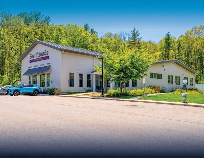


This Property Is For Sale
Property Detail
2 Technology Dr
TYNG-000021-000023-000001D
MIDDLESEX
Animalhospitalvet
Massachusetts
I1
1d
B and X Area of moderate flood hazard, usually the area between the limits of the 100-year and 500-year floods.
2.92 AC
2025
Groton/Townsend
2025
Boston
313101
Boston-Cambridge-Newton, MA-NH
8,878 SF
NEARBY LISTINGS FOR SALE OR LEASE
DEMOGRAPHICS near 2 Technology Dr
1 mile
3 mile
5 mile
2025 Total Population
3,646
28,463
124,162
2030 Population
3,864
29,623
127,898
Pop Growth 2025-2030
+ 5.98%
+ 4.08%
+ 3.01%
Average Age
42
42
41
2025 Total Households
1,483
10,894
45,690
HH Growth 2025-2030
+ 6.07%
+ 4.12%
+ 3.02%
Median Household Inc
$84,198
$117,906
$109,491
Avg Household Size
2.40
2.60
2.60
2025 Avg HH Vehicles
2.00
2.00
2.00
Median Home Value
$461,329
$519,196
$537,313
Median Year Built
1995
1984
1976
Nearby Places
Map Layers
Map Styles
 Street
 Aerial
Layers
 Traffic
 Biking
Places
Listings with unknown addresses are not visible on the map
- Restaurants
- Banks
- Shops
- Fitness
- Groceries
PUBLIC TRANSPORTATION
COMMUTER RAIL
Lowell (Lowell Line - Massachusetts Bay Transportation Authority Commuter Rail (Purple Line))
Drive
Walk
Distance
Lowell (Lowell Line - Massachusetts Bay Transportation Authority Commuter Rail (Purple Line))
14 min
6.7 mi
AIRPORT
Manchester Boston Regional
Drive
Walk
Distance
Manchester Boston Regional
34 min
22.9 mi
General Edward Lawrence Logan International
Drive
Walk
Distance
General Edward Lawrence Logan International
53 min
34.1 mi
Worcester Regional
Drive
Walk
Distance
Worcester Regional
66 min
45.5 mi
Freight Ports
Port of Boston
Drive
Walk
Distance
Port of Boston
54 min
33.9 mi
Nearby Properties
Address
Land Use
TOTAL SIZE
Lot Size
Zoning
Address
Land Use
TOTAL SIZE
Lot Size
Zoning
23,251 SF
18.20 AC
SMF
Address
Land Use
TOTAL SIZE
Lot Size
Zoning
80.11 AC
PI
Address
Land Use
TOTAL SIZE
Lot Size
Zoning
303,508 SF
171.19 AC
G1
Address
Land Use
TOTAL SIZE
Lot Size
Zoning
68.15 AC
R1
Address
Land Use
TOTAL SIZE
Lot Size
Zoning
153,922 SF
6.84 AC
GB
Address
Land Use
TOTAL SIZE
Lot Size
Zoning
44.39 AC
SMU
Address
Land Use
TOTAL SIZE
Lot Size
Zoning
199.97 AC
B2
Address
Land Use
TOTAL SIZE
Lot Size
Zoning
154,620 SF
8.63 AC
GB
Address
Land Use
TOTAL SIZE
Lot Size
Zoning
45.10 AC
R1
Address
Land Use
TOTAL SIZE
Lot Size
Zoning
8.30 AC
B3
Address
Land Use
TOTAL SIZE
Lot Size
Zoning
135,324 SF
70.07 AC
R1
Address
Land Use
TOTAL SIZE
Lot Size
Zoning
90,463 SF
8.56 AC
RA
Address
Land Use
TOTAL SIZE
Lot Size
Zoning
120,888 SF
11.78 AC
HB
Address
Land Use
TOTAL SIZE
Lot Size
Zoning
177.27 AC
R1
Address
Land Use
TOTAL SIZE
Lot Size
Zoning
56,460 SF
5.81 AC
GB
Address
Land Use
TOTAL SIZE
Lot Size
Zoning
12.26 AC
P
Address
Land Use
TOTAL SIZE
Lot Size
Zoning
101,464 SF
8.52 AC
GB
Address
Land Use
TOTAL SIZE
Lot Size
Zoning
149,960 SF
7.85 AC
GB
Address
Land Use
TOTAL SIZE
Lot Size
Zoning
146,536 SF
7.45 AC
GB
Address
Land Use
TOTAL SIZE
Lot Size
Zoning
42,419 SF
2.80 AC
SSF
Address
Land Use
TOTAL SIZE
Lot Size
Zoning
50,000 SF
33.40 AC
IA
Address
Land Use
TOTAL SIZE
Lot Size
Zoning
8.20 AC
SSF
Address
Land Use
TOTAL SIZE
Lot Size
Zoning
71,911 SF
31.55 AC
SSF
Address
Land Use
TOTAL SIZE
Lot Size
Zoning
15.86 AC
B3
Address
Land Use
TOTAL SIZE
Lot Size
Zoning
3.77 AC
B3
Address
Land Use
TOTAL SIZE
Lot Size
Zoning
44,438 SF
3.08 AC
HB
Address
Land Use
TOTAL SIZE
Lot Size
Zoning
58,486 SF
1.77 AC
HB
Address
Land Use
TOTAL SIZE
Lot Size
Zoning
44,100 SF
2.72 AC
HB
Address
Land Use
TOTAL SIZE
Lot Size
Zoning
8.30 AC
R1
Address
Land Use
TOTAL SIZE
Lot Size
Zoning
9.92 AC
SSF
The World's #1 Commercial Real Estate Marketplace
Connect with us
© 2026 CoStar Group
The information above has been obtained from sources believed reliable. While we do not doubt its accuracy we have not verified it and make no guarantee, warranty or representation about it. It is your responsibility to independently confirm its accuracy and completeness. Any projections, opinions, assumptions, or estimates used are for example only and do not represent the current or future performance of the property. The value of this transaction to you depends on tax and other factors which should be evaluated by your tax, financial, and legal advisors. You and your advisors should conduct a careful, independent investigation of the property to determine to your satisfaction the suitability of the property for your needs.