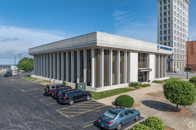
Property Record
2 W Main St, Danville, IL 61832
Property Detail
2 W Main St
Danville, IL
CITY OF DANVILLE ORIGINAL TOWN L1&2, &EX STS,L3-4-5-8 &SW QUAN PBLC SQ & VC ALLY &N46.5'L61S1W, EX 531 S/FROW
23-08-219-002
VERMILION
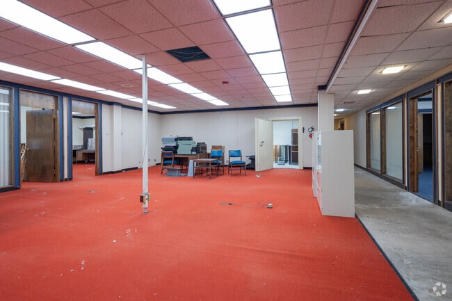
Commercialnec
Illinois
B and X Area of moderate flood hazard, usually the area between the limits of the 100-year and 500-year floods.
l
2024
1.69 AC
2024
Illinois North Area
000100
Other Market Areas
NEARBY LISTINGS FOR SALE OR LEASE
-
-
View all Danville listings for sale on LoopNet.com
DEMOGRAPHICS near 2 W Main St
1 mile
3 mile
5 mile
2025 Total Population
4,826
30,879
40,547
2030 Population
4,841
30,411
39,778
Pop Growth 2025-2030
+ 0.31%
(1.52%)
(1.90%)
Average Age
39
40
41
2025 Total Households
1,985
12,458
16,503
HH Growth 2025-2030
+ 0.15%
(1.76%)
(2.17%)
Median Household Inc
$29,619
$39,132
$41,927
Avg Household Size
2.20
2.30
2.20
2025 Avg HH Vehicles
1.00
1.00
2.00
Median Home Value
$54,156
$74,740
$86,463
Median Year Built
1946
1949
1954
Nearby Places
Map Layers
Map Styles
 Street
 Aerial
Layers
 Traffic
 Biking
Places
Listings with unknown addresses are not visible on the map
- Restaurants
- Banks
- Shops
- Fitness
- Groceries
SALE & LEASE HISTORY
LISTING DATE
SALE/LEASE

Sep 19, 2022
For Sale
Nov 27, 2018
For Lease
May 14, 2024
For Sale
Mar 01, 2019
For Lease
Aug 15, 2017
For Sale
Nearby Properties
Address
Land Use
TOTAL SIZE
Lot Size
Zoning
Address
Land Use
TOTAL SIZE
Lot Size
Zoning
43.88 AC
Address
Land Use
TOTAL SIZE
Lot Size
Zoning
25.03 AC
Address
Land Use
TOTAL SIZE
Lot Size
Zoning
2.86 AC
Address
Land Use
TOTAL SIZE
Lot Size
Zoning
5.17 AC
Address
Land Use
TOTAL SIZE
Lot Size
Zoning
11.64 AC
Address
Land Use
TOTAL SIZE
Lot Size
Zoning
13.47 AC
Address
Land Use
TOTAL SIZE
Lot Size
Zoning
5.94 AC
Address
Land Use
TOTAL SIZE
Lot Size
Zoning
15.40 AC
Address
Land Use
TOTAL SIZE
Lot Size
Zoning
40.50 AC
Address
Land Use
TOTAL SIZE
Lot Size
Zoning
19.35 AC
Address
Land Use
TOTAL SIZE
Lot Size
Zoning
Address
Land Use
TOTAL SIZE
Lot Size
Zoning
1.07 AC
Address
Land Use
TOTAL SIZE
Lot Size
Zoning
Address
Land Use
TOTAL SIZE
Lot Size
Zoning
16.05 AC
Address
Land Use
TOTAL SIZE
Lot Size
Zoning
Address
Land Use
TOTAL SIZE
Lot Size
Zoning
11.95 AC
Address
Land Use
TOTAL SIZE
Lot Size
Zoning
4.13 AC
Address
Land Use
TOTAL SIZE
Lot Size
Zoning
6.84 AC
Address
Land Use
TOTAL SIZE
Lot Size
Zoning
Address
Land Use
TOTAL SIZE
Lot Size
Zoning
Address
Land Use
TOTAL SIZE
Lot Size
Zoning
Address
Land Use
TOTAL SIZE
Lot Size
Zoning
1.50 AC
Address
Land Use
TOTAL SIZE
Lot Size
Zoning
1.02 AC
Address
Land Use
TOTAL SIZE
Lot Size
Zoning
7.39 AC
Address
Land Use
TOTAL SIZE
Lot Size
Zoning
80.25 AC
Address
Land Use
TOTAL SIZE
Lot Size
Zoning
13.48 AC
Address
Land Use
TOTAL SIZE
Lot Size
Zoning
55.15 AC
Address
Land Use
TOTAL SIZE
Lot Size
Zoning
7.13 AC
Address
Land Use
TOTAL SIZE
Lot Size
Zoning
157.07 AC
The World's #1 Commercial Real Estate Marketplace
Connect with us
© 2026 CoStar Group
The information above has been obtained from sources believed reliable. While we do not doubt its accuracy we have not verified it and make no guarantee, warranty or representation about it. It is your responsibility to independently confirm its accuracy and completeness. Any projections, opinions, assumptions, or estimates used are for example only and do not represent the current or future performance of the property. The value of this transaction to you depends on tax and other factors which should be evaluated by your tax, financial, and legal advisors. You and your advisors should conduct a careful, independent investigation of the property to determine to your satisfaction the suitability of the property for your needs.