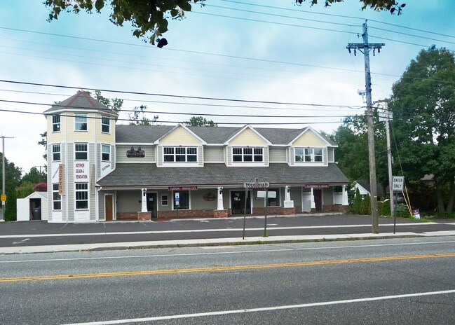
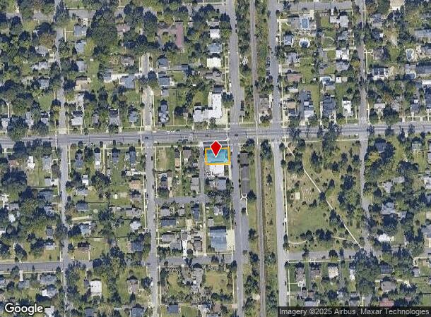
Property Record
2 W Mantua Ave, Wenonah, NJ 08090


NEARBY LISTINGS FOR SALE OR LEASE
Property Detail
2 W Mantua Ave
Philadelphia-Camden-Wilmington, PA-NJ-DE-MD
Incl
19-00050-0000-00004
L5.01
Regionalshoppingcenterormallwithanchorstore
Gloucester
X
New Jersey
34015C0092F
4
2024
0.15 AC
2025
Gloucester County
500800
Philadelphia
4,708 SF
DEMOGRAPHICS near 2 W Mantua Ave
1 Mile
3 Mile
5 Mile
2024 Total Population
6,457
50,509
135,608
2029 Population
6,646
52,180
139,827
Pop Growth 2024-2029
+ 2.93%
+ 3.31%
+ 3.11%
Average Age
42
41
41
2024 Total Households
2,380
19,533
52,382
HH Growth 2024-2029
+ 2.90%
+ 3.35%
+ 3.14%
Median Household Inc
$106,744
$96,330
$95,638
Avg Household Size
2.70
2.50
2.50
2024 Avg HH Vehicles
2.00
2.00
2.00
Median Home Value
$264,117
$271,416
$263,346
Median Year Built
1959
1976
1975
Nearby Places
Map Layers
Map Styles
 Street
 Aerial
- Restaurants
- Banks
- Shops
- Fitness
- Groceries
PUBLIC TRANSPORTATION
AIRPORT
Philadelphia International
DRIVE
WALK
Distance
Philadelphia International
37 min
19.6 mi
Trenton Mercer
DRIVE
WALK
Distance
Trenton Mercer
71 min
45.6 mi
Atlantic City International
DRIVE
WALK
Distance
Atlantic City International
81 min
45.9 mi
Freight Ports
Broadway Terminal - Pier 5
DRIVE
WALK
Distance
Broadway Terminal - Pier 5
20 min
9.6 mi
SALE & LEASE HISTORY
LISTING DATE
SALE/LEASE

Sep 25, 2016
For Lease
Sep 23, 2016
For Sale
Nearby Properties
Address
Land Use
TOTAL SIZE
Lot Size
Zoning
Address
Land Use
TOTAL SIZE
Lot Size
Zoning
228.36 AC
INS
Address
Land Use
TOTAL SIZE
Lot Size
Zoning
32.64 AC
INS
Address
Land Use
TOTAL SIZE
Lot Size
Zoning
32.20 AC
R-1
Address
Land Use
TOTAL SIZE
Lot Size
Zoning
21.32 AC
Address
Land Use
TOTAL SIZE
Lot Size
Zoning
35.50 AC
R4
Address
Land Use
TOTAL SIZE
Lot Size
Zoning
63.46 AC
INS
Address
Land Use
TOTAL SIZE
Lot Size
Zoning
38.17 AC
R4
Address
Land Use
TOTAL SIZE
Lot Size
Zoning
21.16 AC
INS
Address
Land Use
TOTAL SIZE
Lot Size
Zoning
3.22 AC
PA
Address
Land Use
TOTAL SIZE
Lot Size
Zoning
15.98 AC
PC
Address
Land Use
TOTAL SIZE
Lot Size
Zoning
21.81 AC
RM2
Address
Land Use
TOTAL SIZE
Lot Size
Zoning
1,316 SF
16.04 AC
PC
Address
Land Use
TOTAL SIZE
Lot Size
Zoning
Address
Land Use
TOTAL SIZE
Lot Size
Zoning
12.14 AC
Address
Land Use
TOTAL SIZE
Lot Size
Zoning
7.01 AC
R11
Address
Land Use
TOTAL SIZE
Lot Size
Zoning
8.89 AC
Address
Land Use
TOTAL SIZE
Lot Size
Zoning
14.11 AC
SC
Address
Land Use
TOTAL SIZE
Lot Size
Zoning
Address
Land Use
TOTAL SIZE
Lot Size
Zoning
34.49 AC
M1
Address
Land Use
TOTAL SIZE
Lot Size
Zoning
14.14 AC
R11
Address
Land Use
TOTAL SIZE
Lot Size
Zoning
12.73 AC
Address
Land Use
TOTAL SIZE
Lot Size
Zoning
4.39 AC
Address
Land Use
TOTAL SIZE
Lot Size
Zoning
28.70 AC
M1
Address
Land Use
TOTAL SIZE
Lot Size
Zoning
4.47 AC
MU
Address
Land Use
TOTAL SIZE
Lot Size
Zoning
2.62 AC
Address
Land Use
TOTAL SIZE
Lot Size
Zoning
27.40 AC
LI
Address
Land Use
TOTAL SIZE
Lot Size
Zoning
13,221 SF
9.92 AC
HC
Address
Land Use
TOTAL SIZE
Lot Size
Zoning
Address
Land Use
TOTAL SIZE
Lot Size
Zoning
11.51 AC
Address
Land Use
TOTAL SIZE
Lot Size
Zoning
14.43 AC
CC
The World's #1 Commercial Real Estate Marketplace
Connect with us
© 2025 CoStar Group
The information above has been obtained from sources believed reliable. While we do not doubt its accuracy we have not verified it and make no guarantee, warranty or representation about it. It is your responsibility to independently confirm its accuracy and completeness. Any projections, opinions, assumptions, or estimates used are for example only and do not represent the current or future performance of the property. The value of this transaction to you depends on tax and other factors which should be evaluated by your tax, financial, and legal advisors. You and your advisors should conduct a careful, independent investigation of the property to determine to your satisfaction the suitability of the property for your needs.