Property Record
2 Walnut St, Cincinnati, OH 45216
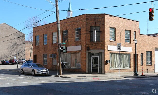
Property Detail
2 Walnut St
Cincinnati, OH-KY-IN
1200 WALNUT ST 50 X 95.10LOTS 121-122 BENHAMS SUB PARS 86-87 CONS
080-0002-0090
HAMILTON
Parkingstructure
Ohio
CCM
121-1
B and X Area of moderate flood hazard, usually the area between the limits of the 100-year and 500-year floods.
0.03 AC
2025
Central/Midtown
2025
Cincinnati/Dayton
001000
NEARBY LISTINGS FOR SALE OR LEASE
DEMOGRAPHICS near 2 Walnut St
1 mile
3 mile
5 mile
2025 Total Population
28,481
159,150
333,456
2030 Population
29,819
164,623
341,937
Pop Growth 2025-2030
+ 4.70%
+ 3.44%
+ 2.54%
Average Age
37
36
37
2025 Total Households
15,186
72,326
147,211
HH Growth 2025-2030
+ 4.89%
+ 3.67%
+ 2.68%
Median Household Inc
$70,335
$55,405
$58,870
Avg Household Size
1.70
2.00
2.10
2025 Avg HH Vehicles
1.00
1.00
1.00
Median Home Value
$443,368
$264,479
$257,545
Median Year Built
1949
1948
1949
Nearby Places
Map Layers
Map Styles
 Street
 Aerial
Transit
 Traffic
 Biking
Places
Listings with unknown addresses are not visible on the map
- Restaurants
- Banks
- Shops
- Fitness
- Groceries
PUBLIC TRANSPORTATION
COMMUTER RAIL
Cincinnati Union Terminal (Cardinal - Amtrak)
Drive
Walk
Distance
Cincinnati Union Terminal (Cardinal - Amtrak)
14 min
8.5 mi
AIRPORT
Cincinnati/Northern Kentucky International
Drive
Walk
Distance
Cincinnati/Northern Kentucky International
39 min
22.5 mi
Freight Ports
Port of Toledo
Drive
Walk
Distance
Port of Toledo
230 min
198.2 mi
Nearby Properties
Address
Land Use
TOTAL SIZE
Lot Size
Zoning
Address
Land Use
TOTAL SIZE
Lot Size
Zoning
62.10 AC
Address
Land Use
TOTAL SIZE
Lot Size
Zoning
Address
Land Use
TOTAL SIZE
Lot Size
Zoning
10.76 AC
Address
Land Use
TOTAL SIZE
Lot Size
Zoning
Address
Land Use
TOTAL SIZE
Lot Size
Zoning
3.34 AC
Address
Land Use
TOTAL SIZE
Lot Size
Zoning
29.67 AC
RM20
Address
Land Use
TOTAL SIZE
Lot Size
Zoning
6.34 AC
Address
Land Use
TOTAL SIZE
Lot Size
Zoning
11,639 SF
7.87 AC
R2
Address
Land Use
TOTAL SIZE
Lot Size
Zoning
14.15 AC
Address
Land Use
TOTAL SIZE
Lot Size
Zoning
23.45 AC
Address
Land Use
TOTAL SIZE
Lot Size
Zoning
330,335 SF
0.80 AC
R3
Address
Land Use
TOTAL SIZE
Lot Size
Zoning
42.41 AC
Address
Land Use
TOTAL SIZE
Lot Size
Zoning
344,923 SF
18.47 AC
RM20
Address
Land Use
TOTAL SIZE
Lot Size
Zoning
Address
Land Use
TOTAL SIZE
Lot Size
Zoning
16.71 AC
Address
Land Use
TOTAL SIZE
Lot Size
Zoning
8.31 AC
RM12
Address
Land Use
TOTAL SIZE
Lot Size
Zoning
437,072 SF
8.03 AC
R2
Address
Land Use
TOTAL SIZE
Lot Size
Zoning
4.14 AC
M2PUD
Address
Land Use
TOTAL SIZE
Lot Size
Zoning
Address
Land Use
TOTAL SIZE
Lot Size
Zoning
4.64 AC
SF20
Address
Land Use
TOTAL SIZE
Lot Size
Zoning
Address
Land Use
TOTAL SIZE
Lot Size
Zoning
Address
Land Use
TOTAL SIZE
Lot Size
Zoning
88.15 AC
ML
Address
Land Use
TOTAL SIZE
Lot Size
Zoning
11,664 SF
29.27 AC
RM20
Address
Land Use
TOTAL SIZE
Lot Size
Zoning
Address
Land Use
TOTAL SIZE
Lot Size
Zoning
8,720 SF
33.28 AC
R3
Address
Land Use
TOTAL SIZE
Lot Size
Zoning
38,102 SF
6.26 AC
SF10
Address
Land Use
TOTAL SIZE
Lot Size
Zoning
Address
Land Use
TOTAL SIZE
Lot Size
Zoning
4.06 AC
M2PUD
Address
Land Use
TOTAL SIZE
Lot Size
Zoning
9.51 AC
The World's #1 Commercial Real Estate Marketplace
Connect with us
© 2026 CoStar Group
The information above has been obtained from sources believed reliable. While we do not doubt its accuracy we have not verified it and make no guarantee, warranty or representation about it. It is your responsibility to independently confirm its accuracy and completeness. Any projections, opinions, assumptions, or estimates used are for example only and do not represent the current or future performance of the property. The value of this transaction to you depends on tax and other factors which should be evaluated by your tax, financial, and legal advisors. You and your advisors should conduct a careful, independent investigation of the property to determine to your satisfaction the suitability of the property for your needs.