Property Record
2 Yorkshire Ln, Belleville, IL 62221
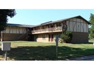

Property Detail
2 Yorkshire Ln
St. Louis, MO-IL
YORKTOWN ESTATES RESUB LOT/SEC-2 DOC A02629734
08-13.0-116-001
Saint Clair
Apartment
Illinois
2024
0.48 AC
2024
Belleville
503334
St. Louis
2,800 SF
NEARBY LISTINGS FOR SALE OR LEASE
DEMOGRAPHICS near 2 Yorkshire Ln
1 mile
3 mile
5 mile
2025 Total Population
7,825
47,066
105,322
2030 Population
7,601
46,063
102,885
Pop Growth 2025-2030
(2.86%)
(2.13%)
(2.31%)
Average Age
41
41
40
2025 Total Households
3,347
19,546
43,890
HH Growth 2025-2030
(2.81%)
(2.12%)
(2.39%)
Median Household Inc
$84,839
$77,845
$74,634
Avg Household Size
2.30
2.30
2.30
2025 Avg HH Vehicles
2.00
2.00
2.00
Median Home Value
$212,700
$202,270
$192,338
Median Year Built
1982
1982
1981
Nearby Places
Map Layers
Map Styles
 Street
 Aerial
Layers
 Traffic
 Biking
Places
Listings with unknown addresses are not visible on the map
- Restaurants
- Banks
- Shops
- Fitness
- Groceries
PUBLIC TRANSPORTATION
COMMUTER RAIL
College (Lambert Airport Shiloh-Scott - St. Louis MetroLink (MetroLink))
Drive
Walk
Distance
College (Lambert Airport Shiloh-Scott - St. Louis MetroLink (MetroLink))
8 min
2.6 mi
Belleville (Lambert Airport Shiloh-Scott - St. Louis MetroLink (MetroLink))
Drive
Walk
Distance
Belleville (Lambert Airport Shiloh-Scott - St. Louis MetroLink (MetroLink))
7 min
3.0 mi
AIRPORT
Scott AFB/Midamerica St Louis
Drive
Walk
Distance
Scott AFB/Midamerica St Louis
21 min
9.7 mi
St Louis Lambert International
Drive
Walk
Distance
St Louis Lambert International
49 min
32.3 mi
Freight Ports
Port Milwaukee
Drive
Walk
Distance
Port Milwaukee
424 min
369.8 mi
Nearby Properties
Address
Land Use
TOTAL SIZE
Lot Size
Zoning
Address
Land Use
TOTAL SIZE
Lot Size
Zoning
70,515 SF
27.95 AC
Address
Land Use
TOTAL SIZE
Lot Size
Zoning
21.84 AC
Address
Land Use
TOTAL SIZE
Lot Size
Zoning
Address
Land Use
TOTAL SIZE
Lot Size
Zoning
9,384 SF
15.93 AC
Address
Land Use
TOTAL SIZE
Lot Size
Zoning
2,937 SF
16.68 AC
Address
Land Use
TOTAL SIZE
Lot Size
Zoning
3,388 SF
22.25 AC
Address
Land Use
TOTAL SIZE
Lot Size
Zoning
20,522 SF
6.42 AC
Address
Land Use
TOTAL SIZE
Lot Size
Zoning
217,542 SF
17.71 AC
Address
Land Use
TOTAL SIZE
Lot Size
Zoning
17,676 SF
3.09 AC
Address
Land Use
TOTAL SIZE
Lot Size
Zoning
30.86 AC
Address
Land Use
TOTAL SIZE
Lot Size
Zoning
167,235 SF
18.91 AC
Address
Land Use
TOTAL SIZE
Lot Size
Zoning
41,366 SF
12.07 AC
Address
Land Use
TOTAL SIZE
Lot Size
Zoning
139,172 SF
15.78 AC
Address
Land Use
TOTAL SIZE
Lot Size
Zoning
8,141 SF
16.74 AC
Address
Land Use
TOTAL SIZE
Lot Size
Zoning
Address
Land Use
TOTAL SIZE
Lot Size
Zoning
Address
Land Use
TOTAL SIZE
Lot Size
Zoning
37,197 SF
6.20 AC
Address
Land Use
TOTAL SIZE
Lot Size
Zoning
125,576 SF
3.48 AC
Address
Land Use
TOTAL SIZE
Lot Size
Zoning
20.63 AC
Address
Land Use
TOTAL SIZE
Lot Size
Zoning
126,937 SF
11.98 AC
Address
Land Use
TOTAL SIZE
Lot Size
Zoning
5,656 SF
8.65 AC
Address
Land Use
TOTAL SIZE
Lot Size
Zoning
4.26 AC
Address
Land Use
TOTAL SIZE
Lot Size
Zoning
30,049 SF
4.53 AC
Address
Land Use
TOTAL SIZE
Lot Size
Zoning
86,482 SF
8 AC
Address
Land Use
TOTAL SIZE
Lot Size
Zoning
46,489 SF
3.66 AC
Address
Land Use
TOTAL SIZE
Lot Size
Zoning
30,000 SF
3.54 AC
Address
Land Use
TOTAL SIZE
Lot Size
Zoning
127,387 SF
11.49 AC
Address
Land Use
TOTAL SIZE
Lot Size
Zoning
Address
Land Use
TOTAL SIZE
Lot Size
Zoning
155,488 SF
16.54 AC
Address
Land Use
TOTAL SIZE
Lot Size
Zoning
7,344 SF
3.50 AC
The World's #1 Commercial Real Estate Marketplace
Connect with us
© 2026 CoStar Group
The information above has been obtained from sources believed reliable. While we do not doubt its accuracy we have not verified it and make no guarantee, warranty or representation about it. It is your responsibility to independently confirm its accuracy and completeness. Any projections, opinions, assumptions, or estimates used are for example only and do not represent the current or future performance of the property. The value of this transaction to you depends on tax and other factors which should be evaluated by your tax, financial, and legal advisors. You and your advisors should conduct a careful, independent investigation of the property to determine to your satisfaction the suitability of the property for your needs.