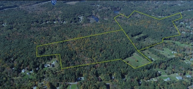
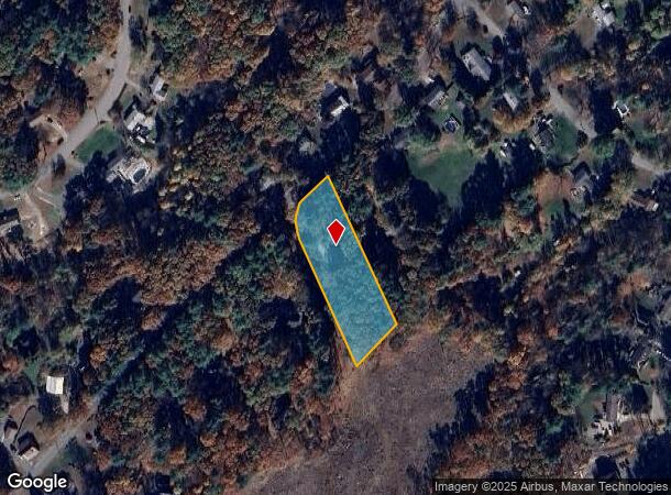
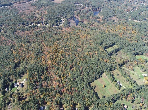
Property Record
20 Berry Rd, Derry, NH 03038
NEARBY LISTINGS FOR SALE OR LEASE
Property Detail
20 Berry Rd
Boston-Cambridge-Newton, MA-NH
Rockingham
DERY-000002-000082-000003
New Hampshire
Sfr
1.30 AC
X
Rockingham
33015C0531E
Boston
1,692 SF
DEMOGRAPHICS near 20 Berry Rd
1 Mile
3 Mile
5 Mile
2024 Total Population
1,799
27,402
62,558
2029 Population
1,828
28,247
64,817
Pop Growth 2024-2029
+ 1.61%
+ 3.08%
+ 3.61%
Average Age
41
41
41
2024 Total Households
650
10,653
23,552
HH Growth 2024-2029
+ 1.38%
+ 2.97%
+ 3.52%
Median Household Inc
$94,230
$97,423
$110,584
Avg Household Size
2.70
2.50
2.60
2024 Avg HH Vehicles
2.00
2.00
2.00
Median Home Value
$323,567
$376,043
$414,645
Median Year Built
1980
1981
1981
Nearby Places
Map Layers
Map Styles
 Street
 Aerial
- Restaurants
- Banks
- Shops
- Fitness
- Groceries
PUBLIC TRANSPORTATION
AIRPORT
Manchester Boston Regional
DRIVE
WALK
Distance
Manchester Boston Regional
29 min
13.7 mi
Portsmouth International at Pease
DRIVE
WALK
Distance
Portsmouth International at Pease
68 min
45.4 mi
Freight Ports
Port of Boston
DRIVE
WALK
Distance
Port of Boston
60 min
42.6 mi
SALE & LEASE HISTORY
LISTING DATE
SALE/LEASE

Nov 07, 2018
For Sale
Nearby Properties
Address
Land Use
TOTAL SIZE
Lot Size
Zoning
Address
Land Use
TOTAL SIZE
Lot Size
Zoning
43.88 AC
MHDR
Address
Land Use
TOTAL SIZE
Lot Size
Zoning
15.44 AC
AR-I
Address
Land Use
TOTAL SIZE
Lot Size
Zoning
54.56 AC
MFR
Address
Land Use
TOTAL SIZE
Lot Size
Zoning
186,072 SF
18.64 AC
C-I
Address
Land Use
TOTAL SIZE
Lot Size
Zoning
146,407 SF
15.39 AC
OMB
Address
Land Use
TOTAL SIZE
Lot Size
Zoning
40.50 AC
MDR
Address
Land Use
TOTAL SIZE
Lot Size
Zoning
133,188 SF
1.53 AC
AR-I
Address
Land Use
TOTAL SIZE
Lot Size
Zoning
12.94 AC
MFR
Address
Land Use
TOTAL SIZE
Lot Size
Zoning
23.03 AC
GC
Address
Land Use
TOTAL SIZE
Lot Size
Zoning
166,979 SF
22.08 AC
MHDR
Address
Land Use
TOTAL SIZE
Lot Size
Zoning
12.73 AC
C-I
Address
Land Use
TOTAL SIZE
Lot Size
Zoning
30.26 AC
C-I
Address
Land Use
TOTAL SIZE
Lot Size
Zoning
154,551 SF
55.80 AC
IND4
Address
Land Use
TOTAL SIZE
Lot Size
Zoning
195,610 SF
20.49 AC
C-I
Address
Land Use
TOTAL SIZE
Lot Size
Zoning
108,248 SF
5.92 AC
OMB
Address
Land Use
TOTAL SIZE
Lot Size
Zoning
79,447 SF
6.83 AC
GC2
Address
Land Use
TOTAL SIZE
Lot Size
Zoning
69,266 SF
6.02 AC
MHDR
Address
Land Use
TOTAL SIZE
Lot Size
Zoning
42,956 SF
2.31 AC
Address
Land Use
TOTAL SIZE
Lot Size
Zoning
16.50 AC
C-II
Address
Land Use
TOTAL SIZE
Lot Size
Zoning
121,108 SF
14.89 AC
IND4
Address
Land Use
TOTAL SIZE
Lot Size
Zoning
3.09 AC
IND4
Address
Land Use
TOTAL SIZE
Lot Size
Zoning
2.73 AC
IND4
Address
Land Use
TOTAL SIZE
Lot Size
Zoning
59,544 SF
20.23 AC
C-II
Address
Land Use
TOTAL SIZE
Lot Size
Zoning
21.72 AC
LMDR
Address
Land Use
TOTAL SIZE
Lot Size
Zoning
32.45 AC
C-II
Address
Land Use
TOTAL SIZE
Lot Size
Zoning
2.21 AC
GC
Address
Land Use
TOTAL SIZE
Lot Size
Zoning
4.10 AC
MFR
Address
Land Use
TOTAL SIZE
Lot Size
Zoning
9.18 AC
IND4
Address
Land Use
TOTAL SIZE
Lot Size
Zoning
4.14 AC
MFR
Address
Land Use
TOTAL SIZE
Lot Size
Zoning
4 AC
MFR
The World's #1 Commercial Real Estate Marketplace
Connect with us
© 2025 CoStar Group
The information above has been obtained from sources believed reliable. While we do not doubt its accuracy we have not verified it and make no guarantee, warranty or representation about it. It is your responsibility to independently confirm its accuracy and completeness. Any projections, opinions, assumptions, or estimates used are for example only and do not represent the current or future performance of the property. The value of this transaction to you depends on tax and other factors which should be evaluated by your tax, financial, and legal advisors. You and your advisors should conduct a careful, independent investigation of the property to determine to your satisfaction the suitability of the property for your needs.