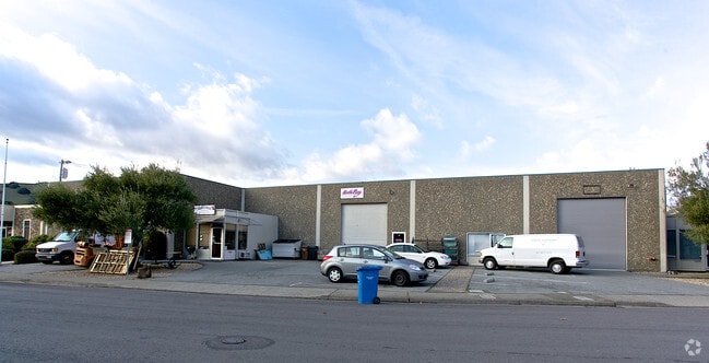
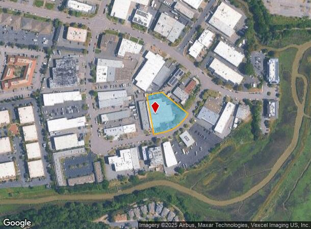
Property Record
20 Mark Dr, San Rafael, CA 94903

Current Lease Availabilities
NEARBY LISTINGS FOR SALE OR LEASE
Property Detail
20 Mark Dr
155-151-36
Northgate Indust Park
Commercialnec
Marin
X
California
06041C0293E
37,38
2025
0.90 AC
2025
San Rafael/Larkspur
106001
North Bay/Santa Rosa
20,640 SF
San Rafael, CA
DEMOGRAPHICS near 20 Mark Dr
1 Mile
3 Mile
5 Mile
2024 Total Population
9,464
56,917
132,987
2029 Population
9,186
55,363
129,249
Pop Growth 2024-2029
(2.94%)
(2.73%)
(2.81%)
Average Age
46
45
45
2024 Total Households
3,899
23,005
52,339
HH Growth 2024-2029
(2.95%)
(2.79%)
(2.84%)
Median Household Inc
$102,340
$110,339
$113,094
Avg Household Size
2.30
2.40
2.40
2024 Avg HH Vehicles
2.00
2.00
2.00
Median Home Value
$838,784
$1,044,772
$1,065,303
Median Year Built
1975
1966
1965
Nearby Places
Map Layers
Map Styles
 Street
 Aerial
- Restaurants
- Banks
- Shops
- Fitness
- Groceries
PUBLIC TRANSPORTATION
COMMUTER RAIL
Marin Civic Center Smart (Main Line - Sonoma Marin Area Rail Transit)
DRIVE
WALK
Distance
Marin Civic Center Smart (Main Line - Sonoma Marin Area Rail Transit)
5 min
2.2 mi
Novato Hamilton Smart (Main Line - Sonoma Marin Area Rail Transit)
DRIVE
WALK
Distance
Novato Hamilton Smart (Main Line - Sonoma Marin Area Rail Transit)
8 min
3.7 mi
AIRPORT
San Francisco International
DRIVE
WALK
Distance
San Francisco International
56 min
35.3 mi
Metro Oakland International
DRIVE
WALK
Distance
Metro Oakland International
49 min
35.4 mi
Freight Ports
Port of Richmond
DRIVE
WALK
Distance
Port of Richmond
27 min
16.1 mi
Nearby Properties
Address
Land Use
TOTAL SIZE
Lot Size
Zoning
Address
Land Use
TOTAL SIZE
Lot Size
Zoning
283,663 SF
27.98 AC
Address
Land Use
TOTAL SIZE
Lot Size
Zoning
23.79 AC
Address
Land Use
TOTAL SIZE
Lot Size
Zoning
221,660 SF
9.69 AC
PC
Address
Land Use
TOTAL SIZE
Lot Size
Zoning
16.43 AC
Address
Land Use
TOTAL SIZE
Lot Size
Zoning
146,832 SF
5.50 AC
Address
Land Use
TOTAL SIZE
Lot Size
Zoning
167,392 SF
12.79 AC
Address
Land Use
TOTAL SIZE
Lot Size
Zoning
68,081 SF
3.41 AC
Address
Land Use
TOTAL SIZE
Lot Size
Zoning
147,502 SF
1.02 AC
Address
Land Use
TOTAL SIZE
Lot Size
Zoning
132,040 SF
11.74 AC
Address
Land Use
TOTAL SIZE
Lot Size
Zoning
11.63 AC
Address
Land Use
TOTAL SIZE
Lot Size
Zoning
75,888 SF
10.99 AC
Address
Land Use
TOTAL SIZE
Lot Size
Zoning
195,460 SF
6.10 AC
Address
Land Use
TOTAL SIZE
Lot Size
Zoning
Address
Land Use
TOTAL SIZE
Lot Size
Zoning
177,460 SF
13 AC
Address
Land Use
TOTAL SIZE
Lot Size
Zoning
11,830 SF
0.65 AC
Address
Land Use
TOTAL SIZE
Lot Size
Zoning
85,066 SF
1.29 AC
Address
Land Use
TOTAL SIZE
Lot Size
Zoning
192,037 SF
511.90 AC
Address
Land Use
TOTAL SIZE
Lot Size
Zoning
139,073 SF
8.98 AC
Address
Land Use
TOTAL SIZE
Lot Size
Zoning
33,641 SF
1.60 AC
Address
Land Use
TOTAL SIZE
Lot Size
Zoning
45,142 SF
2.32 AC
Address
Land Use
TOTAL SIZE
Lot Size
Zoning
6.39 AC
Address
Land Use
TOTAL SIZE
Lot Size
Zoning
142,341 SF
5.83 AC
Address
Land Use
TOTAL SIZE
Lot Size
Zoning
94,625 SF
8.96 AC
Address
Land Use
TOTAL SIZE
Lot Size
Zoning
132,813 SF
6.75 AC
Address
Land Use
TOTAL SIZE
Lot Size
Zoning
77,030 SF
3.34 AC
Address
Land Use
TOTAL SIZE
Lot Size
Zoning
124,196 SF
9.77 AC
Address
Land Use
TOTAL SIZE
Lot Size
Zoning
71,268 SF
5.52 AC
Address
Land Use
TOTAL SIZE
Lot Size
Zoning
7.24 AC
Address
Land Use
TOTAL SIZE
Lot Size
Zoning
The World's #1 Commercial Real Estate Marketplace
Connect with us
© 2026 CoStar Group
The information above has been obtained from sources believed reliable. While we do not doubt its accuracy we have not verified it and make no guarantee, warranty or representation about it. It is your responsibility to independently confirm its accuracy and completeness. Any projections, opinions, assumptions, or estimates used are for example only and do not represent the current or future performance of the property. The value of this transaction to you depends on tax and other factors which should be evaluated by your tax, financial, and legal advisors. You and your advisors should conduct a careful, independent investigation of the property to determine to your satisfaction the suitability of the property for your needs.