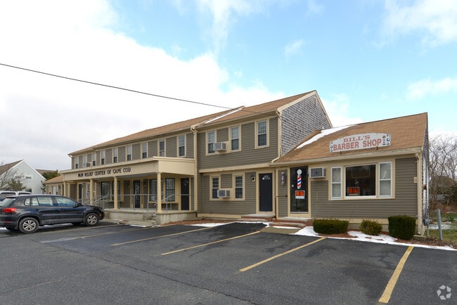
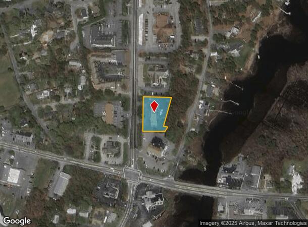
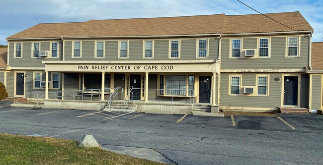
Property Record
26 Route 134, South Dennis, MA 02660
NEARBY LISTINGS FOR SALE OR LEASE
Property Detail
26 Route 134
Officecondo
Cobblestone Court Condo
AE
Barnstable
25001C0592J
Massachusetts
2025
Cape Cod
2025
Other Market Areas
011500
Barnstable Town, MA
620 SF
DENN-000085-000000-000030-000006
DEMOGRAPHICS near 26 Route 134
1 Mile
3 Mile
5 Mile
2024 Total Population
3,435
18,751
46,527
2029 Population
3,623
19,656
48,616
Pop Growth 2024-2029
+ 5.47%
+ 4.83%
+ 4.49%
Average Age
52
52
51
2024 Total Households
1,836
9,064
22,132
HH Growth 2024-2029
+ 5.39%
+ 4.84%
+ 4.47%
Median Household Inc
$54,205
$69,773
$73,048
Avg Household Size
1.80
2.00
2.00
2024 Avg HH Vehicles
2.00
2.00
2.00
Median Home Value
$423,151
$451,059
$462,766
Median Year Built
1965
1969
1972
Nearby Places
Map Layers
Map Styles
 Street
 Aerial
- Restaurants
- Banks
- Shops
- Fitness
- Groceries
PUBLIC TRANSPORTATION
AIRPORT
Barnstable Municipal-Boardman-Polando Field
DRIVE
WALK
Distance
Barnstable Municipal-Boardman-Polando Field
23 min
12.1 mi
Nantucket Memorial
DRIVE
WALK
Distance
Nantucket Memorial
205 min
43.6 mi
SALE & LEASE HISTORY
LISTING DATE
SALE/LEASE

Jul 27, 2017
For Lease
Jan 25, 2021
For Lease
Nearby Properties
Address
Land Use
TOTAL SIZE
Lot Size
Zoning
Address
Land Use
TOTAL SIZE
Lot Size
Zoning
221,710 SF
67.02 AC
Address
Land Use
TOTAL SIZE
Lot Size
Zoning
138,804 SF
15.94 AC
Address
Land Use
TOTAL SIZE
Lot Size
Zoning
Address
Land Use
TOTAL SIZE
Lot Size
Zoning
3.42 AC
Address
Land Use
TOTAL SIZE
Lot Size
Zoning
10.34 AC
Address
Land Use
TOTAL SIZE
Lot Size
Zoning
Address
Land Use
TOTAL SIZE
Lot Size
Zoning
Address
Land Use
TOTAL SIZE
Lot Size
Zoning
14,844 SF
0.50 AC
Address
Land Use
TOTAL SIZE
Lot Size
Zoning
Address
Land Use
TOTAL SIZE
Lot Size
Zoning
Address
Land Use
TOTAL SIZE
Lot Size
Zoning
59,054 SF
9.53 AC
R
Address
Land Use
TOTAL SIZE
Lot Size
Zoning
11,017 SF
5.52 AC
Address
Land Use
TOTAL SIZE
Lot Size
Zoning
1,793 SF
1.32 AC
Address
Land Use
TOTAL SIZE
Lot Size
Zoning
7,134 SF
1.45 AC
Address
Land Use
TOTAL SIZE
Lot Size
Zoning
7,172 SF
1.33 AC
Address
Land Use
TOTAL SIZE
Lot Size
Zoning
0.78 AC
R
Address
Land Use
TOTAL SIZE
Lot Size
Zoning
Address
Land Use
TOTAL SIZE
Lot Size
Zoning
6,276 SF
0.80 AC
R
Address
Land Use
TOTAL SIZE
Lot Size
Zoning
Address
Land Use
TOTAL SIZE
Lot Size
Zoning
0.80 AC
R
Address
Land Use
TOTAL SIZE
Lot Size
Zoning
2,942 SF
130.52 AC
Address
Land Use
TOTAL SIZE
Lot Size
Zoning
14.54 AC
Address
Land Use
TOTAL SIZE
Lot Size
Zoning
45.75 AC
R
Address
Land Use
TOTAL SIZE
Lot Size
Zoning
4,556 SF
1.10 AC
Address
Land Use
TOTAL SIZE
Lot Size
Zoning
38,518 SF
5.09 AC
Address
Land Use
TOTAL SIZE
Lot Size
Zoning
62,423 SF
13.98 AC
Address
Land Use
TOTAL SIZE
Lot Size
Zoning
0.66 AC
R
Address
Land Use
TOTAL SIZE
Lot Size
Zoning
3.17 AC
R
Address
Land Use
TOTAL SIZE
Lot Size
Zoning
0.51 AC
R
Address
Land Use
TOTAL SIZE
Lot Size
Zoning
18.49 AC
The World's #1 Commercial Real Estate Marketplace
Connect with us
© 2025 CoStar Group
The information above has been obtained from sources believed reliable. While we do not doubt its accuracy we have not verified it and make no guarantee, warranty or representation about it. It is your responsibility to independently confirm its accuracy and completeness. Any projections, opinions, assumptions, or estimates used are for example only and do not represent the current or future performance of the property. The value of this transaction to you depends on tax and other factors which should be evaluated by your tax, financial, and legal advisors. You and your advisors should conduct a careful, independent investigation of the property to determine to your satisfaction the suitability of the property for your needs.