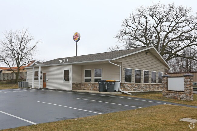
Property Record
20 4Th St Se, Kasson, MN 55944

Save to a Folder
{{folder.Name}}
{{folder.ListingIds.length}} Properties
{{folder.ListingIds.length}} Property
Create a New Folder
Property Detail
20 4Th St Se
Rochester, MN
263200 0 24676 SECT-33 TWP-107 RANGE-016 W E PORTERS ADDITION LOTS 1 & 2 BLK 1
24.676.0040
Dodge
Commercialnec
Minnesota
B and X Area of moderate flood hazard, usually the area between the limits of the 100-year and 500-year floods.
1,2
2025
0.40 AC
2025
Minnesota South Area
950500
Other Market Areas
1,938 SF
NEARBY LISTINGS FOR SALE OR LEASE
DEMOGRAPHICS near 20 4Th St Se
1 mile
3 mile
5 mile
2025 Total Population
5,466
8,902
13,323
2030 Population
5,585
9,087
13,529
Pop Growth 2025-2030
+ 2.18%
+ 2.08%
+ 1.55%
Average Age
37
38
39
2025 Total Households
2,111
3,340
4,936
HH Growth 2025-2030
+ 2.18%
+ 2.10%
+ 1.56%
Median Household Inc
$78,776
$90,521
$97,310
Avg Household Size
2.60
2.70
2.70
2025 Avg HH Vehicles
2.00
2.00
2.00
Median Home Value
$264,414
$286,389
$307,150
Median Year Built
1994
1994
1992
Nearby Places
Map Layers
Map Styles
 Street
 Aerial
Layers
 Traffic
 Biking
Places
Listings with unknown addresses are not visible on the map
- Restaurants
- Banks
- Shops
- Fitness
- Groceries
PUBLIC TRANSPORTATION
AIRPORT
Rochester International
Drive
Walk
Distance
Rochester International
30 min
23.2 mi
Nearby Properties
Address
Land Use
TOTAL SIZE
Lot Size
Zoning
Address
Land Use
TOTAL SIZE
Lot Size
Zoning
199,081 SF
50.63 AC
Address
Land Use
TOTAL SIZE
Lot Size
Zoning
125,562 SF
19.39 AC
Address
Land Use
TOTAL SIZE
Lot Size
Zoning
148,405 SF
44.32 AC
Address
Land Use
TOTAL SIZE
Lot Size
Zoning
59,776 SF
6.12 AC
Address
Land Use
TOTAL SIZE
Lot Size
Zoning
50,936 SF
5 AC
Address
Land Use
TOTAL SIZE
Lot Size
Zoning
2.39 AC
Address
Land Use
TOTAL SIZE
Lot Size
Zoning
1,025 SF
27.93 AC
Address
Land Use
TOTAL SIZE
Lot Size
Zoning
12,340 SF
1.30 AC
Address
Land Use
TOTAL SIZE
Lot Size
Zoning
26,598 SF
80 AC
Address
Land Use
TOTAL SIZE
Lot Size
Zoning
21,608 SF
2.30 AC
Address
Land Use
TOTAL SIZE
Lot Size
Zoning
281.57 AC
Address
Land Use
TOTAL SIZE
Lot Size
Zoning
6.33 AC
Address
Land Use
TOTAL SIZE
Lot Size
Zoning
29,345 SF
5.67 AC
Address
Land Use
TOTAL SIZE
Lot Size
Zoning
238.84 AC
Address
Land Use
TOTAL SIZE
Lot Size
Zoning
10,923 SF
2.80 AC
Address
Land Use
TOTAL SIZE
Lot Size
Zoning
22,638 SF
0.70 AC
Address
Land Use
TOTAL SIZE
Lot Size
Zoning
35,698 SF
2.10 AC
Address
Land Use
TOTAL SIZE
Lot Size
Zoning
12.44 AC
Address
Land Use
TOTAL SIZE
Lot Size
Zoning
Address
Land Use
TOTAL SIZE
Lot Size
Zoning
209.70 AC
Address
Land Use
TOTAL SIZE
Lot Size
Zoning
1,064 SF
185.83 AC
Address
Land Use
TOTAL SIZE
Lot Size
Zoning
9,643 SF
4.30 AC
Address
Land Use
TOTAL SIZE
Lot Size
Zoning
2,500 SF
8.08 AC
Address
Land Use
TOTAL SIZE
Lot Size
Zoning
226.82 AC
Address
Land Use
TOTAL SIZE
Lot Size
Zoning
Address
Land Use
TOTAL SIZE
Lot Size
Zoning
157.68 AC
Address
Land Use
TOTAL SIZE
Lot Size
Zoning
Address
Land Use
TOTAL SIZE
Lot Size
Zoning
150 AC
Address
Land Use
TOTAL SIZE
Lot Size
Zoning
150.34 AC
Address
Land Use
TOTAL SIZE
Lot Size
Zoning
35,176 SF
2.30 AC
The World's #1 Commercial Real Estate Marketplace
Connect with us
© 2026 CoStar Group
The information above has been obtained from sources believed reliable. While we do not doubt its accuracy we have not verified it and make no guarantee, warranty or representation about it. It is your responsibility to independently confirm its accuracy and completeness. Any projections, opinions, assumptions, or estimates used are for example only and do not represent the current or future performance of the property. The value of this transaction to you depends on tax and other factors which should be evaluated by your tax, financial, and legal advisors. You and your advisors should conduct a careful, independent investigation of the property to determine to your satisfaction the suitability of the property for your needs.