Property Record
20 Baird Pky, Mansfield, OH 44903


Save to a Folder
{{folder.Name}}
{{folder.ListingIds.length}} Properties
{{folder.ListingIds.length}} Property
Create a New Folder
Property Detail
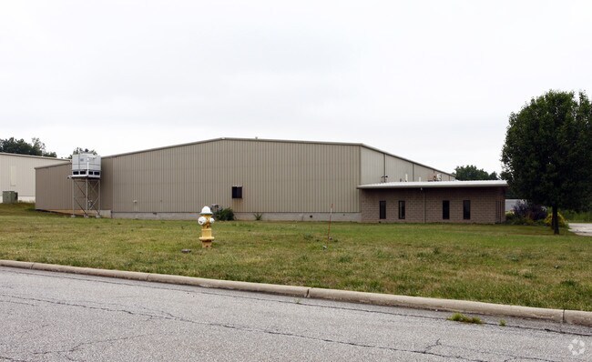
20 Baird Pky
013-89-014-03-000
BAIRD PARKWAY PARCEL 12 LEASED BRIETINGER 5.653 ACRES ABATE -002 COMPLETE TY18
Manufacturinglight
Richland
B and X Area of moderate flood hazard, usually the area between the limits of the 100-year and 500-year floods.
Ohio
2025
5.65 AC
2025
Richland County
001700
Cleveland
32,000 SF
Mansfield, OH
NEARBY LISTINGS FOR SALE OR LEASE
DEMOGRAPHICS near 20 Baird Pky
1 mile
3 mile
5 mile
2025 Total Population
160
9,207
38,693
2030 Population
156
9,154
38,769
Pop Growth 2025-2030
(2.50%)
(0.58%)
+ 0.20%
Average Age
42
43
41
2025 Total Households
59
1,623
13,852
HH Growth 2025-2030
(3.39%)
(1.42%)
+ 0.22%
Median Household Inc
$74,999
$62,433
$47,641
Avg Household Size
2.60
2.30
2.30
2025 Avg HH Vehicles
2.00
2.00
2.00
Median Home Value
$237,500
$169,289
$122,660
Median Year Built
1962
1963
1958
Nearby Places
Map Layers
Map Styles
 Street
 Aerial
Layers
 Traffic
 Biking
Places
Listings with unknown addresses are not visible on the map
- Restaurants
- Banks
- Shops
- Fitness
- Groceries
Nearby Properties
Address
Land Use
TOTAL SIZE
Lot Size
Zoning
Address
Land Use
TOTAL SIZE
Lot Size
Zoning
456.50 AC
Address
Land Use
TOTAL SIZE
Lot Size
Zoning
27,360 SF
63.77 AC
Address
Land Use
TOTAL SIZE
Lot Size
Zoning
404,200 SF
14.77 AC
Address
Land Use
TOTAL SIZE
Lot Size
Zoning
221,864 SF
20 AC
Address
Land Use
TOTAL SIZE
Lot Size
Zoning
318,366 SF
26.16 AC
Address
Land Use
TOTAL SIZE
Lot Size
Zoning
458,316 SF
27.90 AC
Address
Land Use
TOTAL SIZE
Lot Size
Zoning
4,950 SF
158.55 AC
Address
Land Use
TOTAL SIZE
Lot Size
Zoning
161,800 SF
15.87 AC
Address
Land Use
TOTAL SIZE
Lot Size
Zoning
47.90 AC
Address
Land Use
TOTAL SIZE
Lot Size
Zoning
31,064 SF
9 AC
Address
Land Use
TOTAL SIZE
Lot Size
Zoning
103,000 SF
17.38 AC
Address
Land Use
TOTAL SIZE
Lot Size
Zoning
34,320 SF
20.54 AC
Address
Land Use
TOTAL SIZE
Lot Size
Zoning
163,292 SF
16.76 AC
Address
Land Use
TOTAL SIZE
Lot Size
Zoning
80,000 SF
12.10 AC
Address
Land Use
TOTAL SIZE
Lot Size
Zoning
138,116 SF
21.57 AC
Address
Land Use
TOTAL SIZE
Lot Size
Zoning
101,000 SF
5.81 AC
Address
Land Use
TOTAL SIZE
Lot Size
Zoning
16.38 AC
Address
Land Use
TOTAL SIZE
Lot Size
Zoning
152,800 SF
7.66 AC
Address
Land Use
TOTAL SIZE
Lot Size
Zoning
68,500 SF
5.65 AC
Address
Land Use
TOTAL SIZE
Lot Size
Zoning
10,800 SF
20.17 AC
Address
Land Use
TOTAL SIZE
Lot Size
Zoning
119,756 SF
7.14 AC
Address
Land Use
TOTAL SIZE
Lot Size
Zoning
1,728 SF
160 AC
Address
Land Use
TOTAL SIZE
Lot Size
Zoning
68,908 SF
5 AC
Address
Land Use
TOTAL SIZE
Lot Size
Zoning
84,470 SF
18.55 AC
Address
Land Use
TOTAL SIZE
Lot Size
Zoning
Address
Land Use
TOTAL SIZE
Lot Size
Zoning
177,933 SF
7.08 AC
Address
Land Use
TOTAL SIZE
Lot Size
Zoning
18,799 SF
5.50 AC
Address
Land Use
TOTAL SIZE
Lot Size
Zoning
46,584 SF
4.31 AC
Address
Land Use
TOTAL SIZE
Lot Size
Zoning
40,880 SF
10.99 AC
Address
Land Use
TOTAL SIZE
Lot Size
Zoning
163.87 AC
The World's #1 Commercial Real Estate Marketplace
Connect with us
© 2026 CoStar Group
The information above has been obtained from sources believed reliable. While we do not doubt its accuracy we have not verified it and make no guarantee, warranty or representation about it. It is your responsibility to independently confirm its accuracy and completeness. Any projections, opinions, assumptions, or estimates used are for example only and do not represent the current or future performance of the property. The value of this transaction to you depends on tax and other factors which should be evaluated by your tax, financial, and legal advisors. You and your advisors should conduct a careful, independent investigation of the property to determine to your satisfaction the suitability of the property for your needs.