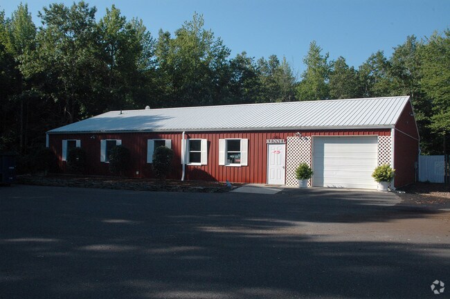
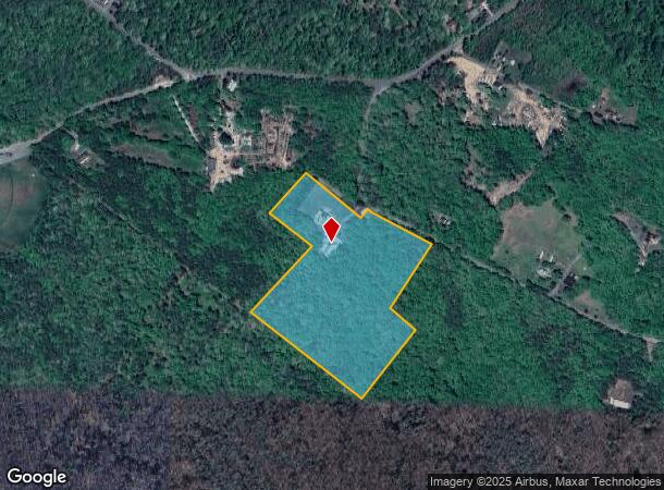
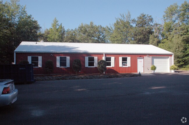
Property Record
20 Collinstown Rd, Barnegat, NJ 08005
NEARBY LISTINGS FOR SALE OR LEASE
Property Detail
20 Collinstown Rd
New York-Jersey City-White Plains, NY-NJ
Sally Wiedmont
01-00262-0000-00037
14.58 AC ANIMAL SHELTER
Governmentalpublicusegeneral
Ocean
X
New Jersey
34029C0501G
37
0
14.58 AC
2025
Ocean County
734003
Northern New Jersey
7,274 SF
DEMOGRAPHICS near 20 Collinstown Rd
1 Mile
3 Mile
5 Mile
2024 Total Population
1,200
26,690
63,555
2029 Population
1,282
28,526
68,539
Pop Growth 2024-2029
+ 6.83%
+ 6.88%
+ 7.84%
Average Age
38
41
44
2024 Total Households
435
9,798
24,839
HH Growth 2024-2029
+ 6.67%
+ 6.53%
+ 7.57%
Median Household Inc
$83,272
$89,860
$88,705
Avg Household Size
2.60
2.60
2.50
2024 Avg HH Vehicles
2.00
2.00
2.00
Median Home Value
$299,424
$313,508
$323,228
Median Year Built
1988
1990
1992
Nearby Places
Map Layers
Map Styles
 Street
 Aerial
- Restaurants
- Banks
- Shops
- Fitness
- Groceries
PUBLIC TRANSPORTATION
AIRPORT
Atlantic City International
DRIVE
WALK
Distance
Atlantic City International
67 min
35.8 mi
Freight Ports
Port of Philadelphia
DRIVE
WALK
Distance
Port of Philadelphia
72 min
55.1 mi
Nearby Properties
Address
Land Use
TOTAL SIZE
Lot Size
Zoning
Address
Land Use
TOTAL SIZE
Lot Size
Zoning
85.65 AC
R40
Address
Land Use
TOTAL SIZE
Lot Size
Zoning
46.40 AC
ML-4
Address
Land Use
TOTAL SIZE
Lot Size
Zoning
13.83 AC
CN
Address
Land Use
TOTAL SIZE
Lot Size
Zoning
85.65 AC
R40
Address
Land Use
TOTAL SIZE
Lot Size
Zoning
91.97 AC
RGL/
Address
Land Use
TOTAL SIZE
Lot Size
Zoning
7.49 AC
R20
Address
Land Use
TOTAL SIZE
Lot Size
Zoning
67,548 SF
10.98 AC
CN
Address
Land Use
TOTAL SIZE
Lot Size
Zoning
86,000 SF
2.87 AC
R20
Address
Land Use
TOTAL SIZE
Lot Size
Zoning
37.27 AC
RGL/
Address
Land Use
TOTAL SIZE
Lot Size
Zoning
6.36 AC
RGL/
Address
Land Use
TOTAL SIZE
Lot Size
Zoning
23.70 AC
BCWD
Address
Land Use
TOTAL SIZE
Lot Size
Zoning
56.23 AC
BC
Address
Land Use
TOTAL SIZE
Lot Size
Zoning
11,695 SF
9.31 AC
R20
Address
Land Use
TOTAL SIZE
Lot Size
Zoning
4,230 SF
10.65 AC
CPHD
Address
Land Use
TOTAL SIZE
Lot Size
Zoning
4.85 AC
CPHD
Address
Land Use
TOTAL SIZE
Lot Size
Zoning
398 AC
PW
Address
Land Use
TOTAL SIZE
Lot Size
Zoning
3.34 AC
C-1
Address
Land Use
TOTAL SIZE
Lot Size
Zoning
5.14 AC
CPHD
Address
Land Use
TOTAL SIZE
Lot Size
Zoning
58,375 SF
5.46 AC
CPHD
Address
Land Use
TOTAL SIZE
Lot Size
Zoning
37,476 SF
14.66 AC
R6
Address
Land Use
TOTAL SIZE
Lot Size
Zoning
11.91 AC
RA
Address
Land Use
TOTAL SIZE
Lot Size
Zoning
52,212 SF
4.41 AC
TCCN
Address
Land Use
TOTAL SIZE
Lot Size
Zoning
32,964 SF
4.01 AC
RB
Address
Land Use
TOTAL SIZE
Lot Size
Zoning
6.84 AC
MLP
Address
Land Use
TOTAL SIZE
Lot Size
Zoning
31,658 SF
5.88 AC
TCCN
Address
Land Use
TOTAL SIZE
Lot Size
Zoning
6.39 AC
ML-1
Address
Land Use
TOTAL SIZE
Lot Size
Zoning
6.03 AC
MU
Address
Land Use
TOTAL SIZE
Lot Size
Zoning
13,593 SF
2.11 AC
CN
Address
Land Use
TOTAL SIZE
Lot Size
Zoning
5,430 SF
2.15 AC
CN
Address
Land Use
TOTAL SIZE
Lot Size
Zoning
4.70 AC
ML5
The World's #1 Commercial Real Estate Marketplace
Connect with us
© 2025 CoStar Group
The information above has been obtained from sources believed reliable. While we do not doubt its accuracy we have not verified it and make no guarantee, warranty or representation about it. It is your responsibility to independently confirm its accuracy and completeness. Any projections, opinions, assumptions, or estimates used are for example only and do not represent the current or future performance of the property. The value of this transaction to you depends on tax and other factors which should be evaluated by your tax, financial, and legal advisors. You and your advisors should conduct a careful, independent investigation of the property to determine to your satisfaction the suitability of the property for your needs.