Property Record
20 County Rd, Mattapoisett, MA 02739

Save to a Folder
{{folder.Name}}
{{folder.ListingIds.length}} Properties
{{folder.ListingIds.length}} Property
Create a New Folder
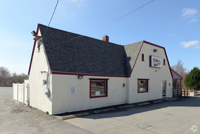
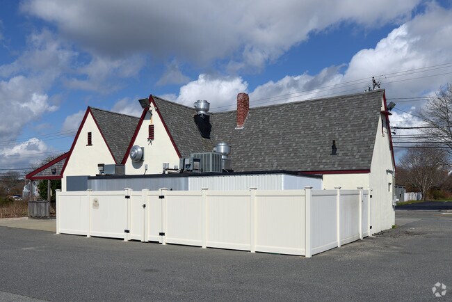
Property Detail
20 County Rd
MATT-000090-000000-001980
Plymouth
Restaurantbuilding
Massachusetts
GB
198.0
B and X Area of moderate flood hazard, usually the area between the limits of the 100-year and 500-year floods.
0.34 AC
2025
Route 3 South
2025
Boston
560100
Boston-Cambridge-Newton, MA-NH
1,194 SF
NEARBY LISTINGS FOR SALE OR LEASE
-
-
View all Mattapoisett listings for sale on LoopNet.com
DEMOGRAPHICS near 20 County Rd
1 mile
3 mile
5 mile
2025 Total Population
2,350
10,514
31,724
2030 Population
2,420
10,995
32,739
Pop Growth 2025-2030
+ 2.98%
+ 4.57%
+ 3.20%
Average Age
49
47
46
2025 Total Households
1,057
4,358
13,309
HH Growth 2025-2030
+ 2.84%
+ 4.59%
+ 3.25%
Median Household Inc
$101,302
$117,398
$101,009
Avg Household Size
2.20
2.40
2.30
2025 Avg HH Vehicles
2.00
2.00
2.00
Median Home Value
$712,851
$714,995
$550,198
Median Year Built
1970
1977
1962
Nearby Places
Map Layers
Map Styles
 Street
 Aerial
Layers
 Traffic
 Biking
Places
Listings with unknown addresses are not visible on the map
- Restaurants
- Banks
- Shops
- Fitness
- Groceries
Nearby Properties
Address
Land Use
TOTAL SIZE
Lot Size
Zoning
Address
Land Use
TOTAL SIZE
Lot Size
Zoning
93.69 AC
RR3
Address
Land Use
TOTAL SIZE
Lot Size
Zoning
75,674 SF
7.62 AC
VR1
Address
Land Use
TOTAL SIZE
Lot Size
Zoning
73,520 SF
18.44 AC
R45
Address
Land Use
TOTAL SIZE
Lot Size
Zoning
288 SF
22.53 AC
RR8
Address
Land Use
TOTAL SIZE
Lot Size
Zoning
74,630 SF
15.20 AC
RA
Address
Land Use
TOTAL SIZE
Lot Size
Zoning
6,670 SF
12.30 AC
GB
Address
Land Use
TOTAL SIZE
Lot Size
Zoning
114,900 SF
6.47 AC
LI
Address
Land Use
TOTAL SIZE
Lot Size
Zoning
6.11 AC
R30
Address
Land Use
TOTAL SIZE
Lot Size
Zoning
11,064 SF
0.72 AC
VR1
Address
Land Use
TOTAL SIZE
Lot Size
Zoning
207 AC
W30
Address
Land Use
TOTAL SIZE
Lot Size
Zoning
4.50 AC
MR3
Address
Land Use
TOTAL SIZE
Lot Size
Zoning
14,724 SF
2.26 AC
R30
Address
Land Use
TOTAL SIZE
Lot Size
Zoning
3 AC
1737
Address
Land Use
TOTAL SIZE
Lot Size
Zoning
41,750 SF
4.01 AC
LI
Address
Land Use
TOTAL SIZE
Lot Size
Zoning
24.40 AC
RR3
Address
Land Use
TOTAL SIZE
Lot Size
Zoning
1.50 AC
VR1
Address
Land Use
TOTAL SIZE
Lot Size
Zoning
3.66 AC
R30
Address
Land Use
TOTAL SIZE
Lot Size
Zoning
1,362 SF
1.92 AC
R30
Address
Land Use
TOTAL SIZE
Lot Size
Zoning
199 AC
RR8
Address
Land Use
TOTAL SIZE
Lot Size
Zoning
4,648 SF
3.41 AC
GB
Address
Land Use
TOTAL SIZE
Lot Size
Zoning
5.33 AC
LI
Address
Land Use
TOTAL SIZE
Lot Size
Zoning
401.90 AC
RR4
Address
Land Use
TOTAL SIZE
Lot Size
Zoning
5.42 AC
VR1
Address
Land Use
TOTAL SIZE
Lot Size
Zoning
6.31 AC
LI
Address
Land Use
TOTAL SIZE
Lot Size
Zoning
2,346 SF
34.55 AC
R45
Address
Land Use
TOTAL SIZE
Lot Size
Zoning
12,096 SF
1.57 AC
VR1
Address
Land Use
TOTAL SIZE
Lot Size
Zoning
3.44 AC
709
Address
Land Use
TOTAL SIZE
Lot Size
Zoning
1.17 AC
MR3
Address
Land Use
TOTAL SIZE
Lot Size
Zoning
1.15 AC
MR3
Address
Land Use
TOTAL SIZE
Lot Size
Zoning
45,000 SF
2.84 AC
LI
The World's #1 Commercial Real Estate Marketplace
Connect with us
© 2026 CoStar Group
The information above has been obtained from sources believed reliable. While we do not doubt its accuracy we have not verified it and make no guarantee, warranty or representation about it. It is your responsibility to independently confirm its accuracy and completeness. Any projections, opinions, assumptions, or estimates used are for example only and do not represent the current or future performance of the property. The value of this transaction to you depends on tax and other factors which should be evaluated by your tax, financial, and legal advisors. You and your advisors should conduct a careful, independent investigation of the property to determine to your satisfaction the suitability of the property for your needs.