Property Record
20 Daniel Boone Plz, Hazard, KY 41701

Save to a Folder
{{folder.Name}}
{{folder.ListingIds.length}} Properties
{{folder.ListingIds.length}} Property
Create a New Folder
Property Detail
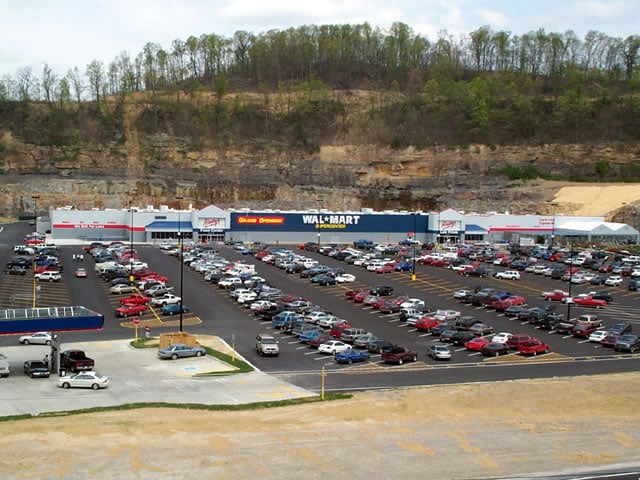
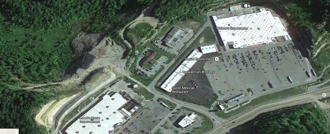
20 Daniel Boone Plz
085-00-00-006.08
DB 313 PG 370 01-03-2005
Commercialnec
Perry
B and X Area of moderate flood hazard, usually the area between the limits of the 100-year and 500-year floods.
Kentucky
2023
5.35 AC
2025
Kentucky East Area
970400
Other Market Areas
50,949 SF
NEARBY LISTINGS FOR SALE OR LEASE
DEMOGRAPHICS near 20 Daniel Boone Plz
1 mile
3 mile
5 mile
2025 Total Population
852
6,187
14,374
2030 Population
824
5,967
14,006
Pop Growth 2025-2030
(3.29%)
(3.56%)
(2.56%)
Average Age
42
42
41
2025 Total Households
318
2,378
5,772
HH Growth 2025-2030
(3.14%)
(3.66%)
(2.56%)
Median Household Inc
$52,884
$44,444
$41,465
Avg Household Size
2.30
2.40
2.30
2025 Avg HH Vehicles
2.00
2.00
2.00
Median Home Value
$74,811
$92,385
$105,324
Median Year Built
1985
1988
1982
Nearby Places
Map Layers
Map Styles
 Street
 Aerial
Layers
 Traffic
 Biking
Places
Listings with unknown addresses are not visible on the map
- Restaurants
- Banks
- Shops
- Fitness
- Groceries
SALE & LEASE HISTORY
LISTING DATE
SALE/LEASE

Mar 10, 2017
For Lease
Nearby Properties
Address
Land Use
TOTAL SIZE
Lot Size
Zoning
Address
Land Use
TOTAL SIZE
Lot Size
Zoning
Address
Land Use
TOTAL SIZE
Lot Size
Zoning
31.07 AC
Address
Land Use
TOTAL SIZE
Lot Size
Zoning
196,287 SF
19.65 AC
R
Address
Land Use
TOTAL SIZE
Lot Size
Zoning
90,000 SF
33.98 AC
Address
Land Use
TOTAL SIZE
Lot Size
Zoning
22 AC
Address
Land Use
TOTAL SIZE
Lot Size
Zoning
16,725 SF
R
Address
Land Use
TOTAL SIZE
Lot Size
Zoning
15,750 SF
Address
Land Use
TOTAL SIZE
Lot Size
Zoning
94,000 SF
11.50 AC
R
Address
Land Use
TOTAL SIZE
Lot Size
Zoning
6,000 SF
42 AC
Address
Land Use
TOTAL SIZE
Lot Size
Zoning
Address
Land Use
TOTAL SIZE
Lot Size
Zoning
50,000 SF
1.62 AC
R
Address
Land Use
TOTAL SIZE
Lot Size
Zoning
41,874 SF
1.40 AC
R
Address
Land Use
TOTAL SIZE
Lot Size
Zoning
1,100 SF
0.89 AC
Address
Land Use
TOTAL SIZE
Lot Size
Zoning
2,068 SF
6 AC
Address
Land Use
TOTAL SIZE
Lot Size
Zoning
60,285 SF
3.66 AC
Address
Land Use
TOTAL SIZE
Lot Size
Zoning
1.14 AC
Address
Land Use
TOTAL SIZE
Lot Size
Zoning
19,730 SF
4 AC
Address
Land Use
TOTAL SIZE
Lot Size
Zoning
12,238 SF
8 AC
Address
Land Use
TOTAL SIZE
Lot Size
Zoning
33,618 SF
16 AC
Address
Land Use
TOTAL SIZE
Lot Size
Zoning
Address
Land Use
TOTAL SIZE
Lot Size
Zoning
2.45 AC
Address
Land Use
TOTAL SIZE
Lot Size
Zoning
9,500 SF
0.80 AC
Address
Land Use
TOTAL SIZE
Lot Size
Zoning
7.43 AC
R
Address
Land Use
TOTAL SIZE
Lot Size
Zoning
Address
Land Use
TOTAL SIZE
Lot Size
Zoning
3,780 SF
Address
Land Use
TOTAL SIZE
Lot Size
Zoning
19,967 SF
3.30 AC
R
Address
Land Use
TOTAL SIZE
Lot Size
Zoning
43,447 SF
3.23 AC
Address
Land Use
TOTAL SIZE
Lot Size
Zoning
27,329 SF
The World's #1 Commercial Real Estate Marketplace
Connect with us
© 2026 CoStar Group
The information above has been obtained from sources believed reliable. While we do not doubt its accuracy we have not verified it and make no guarantee, warranty or representation about it. It is your responsibility to independently confirm its accuracy and completeness. Any projections, opinions, assumptions, or estimates used are for example only and do not represent the current or future performance of the property. The value of this transaction to you depends on tax and other factors which should be evaluated by your tax, financial, and legal advisors. You and your advisors should conduct a careful, independent investigation of the property to determine to your satisfaction the suitability of the property for your needs.