Property Record
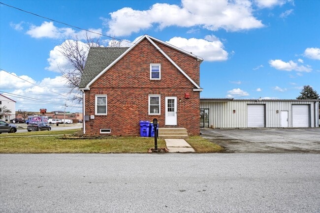
20 E 11Th Ave, York, PA 17404


Property Detail
20 E 11Th Ave
Warehouse
YORK
CM
Pennsylvania
B and X Area of moderate flood hazard, usually the area between the limits of the 100-year and 500-year floods.
0.57 AC
2026
York County
2026
Philadelphia
021223
York-Hanover, PA
6,460 SF
80-000-05-0159.00-00000
NEARBY LISTINGS FOR SALE OR LEASE
DEMOGRAPHICS near 20 E 11Th Ave
1 mile
3 mile
5 mile
2025 Total Population
8,054
90,337
156,142
2030 Population
8,306
92,716
160,632
Pop Growth 2025-2030
+ 3.13%
+ 2.63%
+ 2.88%
Average Age
39
38
40
2025 Total Households
3,349
34,817
60,523
HH Growth 2025-2030
+ 3.19%
+ 2.75%
+ 3.00%
Median Household Inc
$59,886
$64,805
$72,738
Avg Household Size
2.30
2.40
2.40
2025 Avg HH Vehicles
2.00
2.00
2.00
Median Home Value
$151,789
$181,602
$236,197
Median Year Built
1954
1953
1964
Nearby Places
Map Layers
Map Styles
 Street
 Aerial
Layers
 Traffic
 Biking
Places
Listings with unknown addresses are not visible on the map
- Restaurants
- Banks
- Shops
- Fitness
- Groceries
PUBLIC TRANSPORTATION
AIRPORT
Harrisburg International
Drive
Walk
Distance
Harrisburg International
38 min
28.3 mi
Freight Ports
Port of Baltimore
Drive
Walk
Distance
Port of Baltimore
81 min
58.4 mi
SALE & LEASE HISTORY
LISTING DATE
SALE/LEASE

Sep 15, 2025
For Lease
Nearby Properties
Address
Land Use
TOTAL SIZE
Lot Size
Zoning
Address
Land Use
TOTAL SIZE
Lot Size
Zoning
21 AC
I
Address
Land Use
TOTAL SIZE
Lot Size
Zoning
779,291 SF
95.61 AC
I
Address
Land Use
TOTAL SIZE
Lot Size
Zoning
2,858 SF
46.24 AC
CM
Address
Land Use
TOTAL SIZE
Lot Size
Zoning
1,068,680 SF
64.22 AC
I
Address
Land Use
TOTAL SIZE
Lot Size
Zoning
754,640 SF
54.36 AC
Address
Land Use
TOTAL SIZE
Lot Size
Zoning
123,796 SF
26.99 AC
CH
Address
Land Use
TOTAL SIZE
Lot Size
Zoning
347,456 SF
58.09 AC
RS
Address
Land Use
TOTAL SIZE
Lot Size
Zoning
19,728 SF
66.17 AC
CM
Address
Land Use
TOTAL SIZE
Lot Size
Zoning
170,850 SF
27.83 AC
FD
Address
Land Use
TOTAL SIZE
Lot Size
Zoning
2,880 SF
28.39 AC
ID
Address
Land Use
TOTAL SIZE
Lot Size
Zoning
28.77 AC
I
Address
Land Use
TOTAL SIZE
Lot Size
Zoning
12,432 SF
27.56 AC
R1
Address
Land Use
TOTAL SIZE
Lot Size
Zoning
12.12 AC
Address
Land Use
TOTAL SIZE
Lot Size
Zoning
373,298 SF
24.55 AC
GI
Address
Land Use
TOTAL SIZE
Lot Size
Zoning
14.17 AC
RS
Address
Land Use
TOTAL SIZE
Lot Size
Zoning
44,800 SF
18.73 AC
CM
Address
Land Use
TOTAL SIZE
Lot Size
Zoning
483,676 SF
165.85 AC
I
Address
Land Use
TOTAL SIZE
Lot Size
Zoning
11.22 AC
Address
Land Use
TOTAL SIZE
Lot Size
Zoning
340,000 SF
24.63 AC
I
Address
Land Use
TOTAL SIZE
Lot Size
Zoning
379,696 SF
19.42 AC
GI
Address
Land Use
TOTAL SIZE
Lot Size
Zoning
57,358 SF
9 AC
NC
Address
Land Use
TOTAL SIZE
Lot Size
Zoning
471,400 SF
31.22 AC
ID
Address
Land Use
TOTAL SIZE
Lot Size
Zoning
6.44 AC
RS
Address
Land Use
TOTAL SIZE
Lot Size
Zoning
81,681 SF
4.04 AC
RS
Address
Land Use
TOTAL SIZE
Lot Size
Zoning
43,200 SF
19 AC
RH
Address
Land Use
TOTAL SIZE
Lot Size
Zoning
55,276 SF
40.39 AC
I
Address
Land Use
TOTAL SIZE
Lot Size
Zoning
30,952 SF
9.95 AC
CM
Address
Land Use
TOTAL SIZE
Lot Size
Zoning
133,416 SF
14.08 AC
RS
Address
Land Use
TOTAL SIZE
Lot Size
Zoning
30,060 SF
11.17 AC
RS
Address
Land Use
TOTAL SIZE
Lot Size
Zoning
24,323 SF
39.43 AC
I
The World's #1 Commercial Real Estate Marketplace
Connect with us
© 2026 CoStar Group
The information above has been obtained from sources believed reliable. While we do not doubt its accuracy we have not verified it and make no guarantee, warranty or representation about it. It is your responsibility to independently confirm its accuracy and completeness. Any projections, opinions, assumptions, or estimates used are for example only and do not represent the current or future performance of the property. The value of this transaction to you depends on tax and other factors which should be evaluated by your tax, financial, and legal advisors. You and your advisors should conduct a careful, independent investigation of the property to determine to your satisfaction the suitability of the property for your needs.