Property Record
20 E State Road 54, Sullivan, IN 47882


Save to a Folder
{{folder.Name}}
{{folder.ListingIds.length}} Properties
{{folder.ListingIds.length}} Property
Create a New Folder
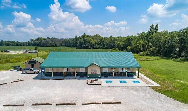
Property Detail
20 E State Road 54
Terre Haute, IN
NW COR SW 209' X 209' 03-07-09 .873AC
77-10-03-000-030.000-012
Sullivan
Commercialnec
Indiana
2024
0.87 AC
2025
Indiana South Area
050400
Other Market Areas
3,280 SF
NEARBY LISTINGS FOR SALE OR LEASE
DEMOGRAPHICS near 20 E State Road 54
1 mile
3 mile
5 mile
2025 Total Population
800
5,576
7,691
2030 Population
805
5,608
7,740
Pop Growth 2025-2030
+ 0.63%
+ 0.57%
+ 0.64%
Average Age
41
41
41
2025 Total Households
364
2,422
3,266
HH Growth 2025-2030
+ 0.55%
+ 0.58%
+ 0.61%
Median Household Inc
$31,500
$48,397
$51,797
Avg Household Size
2.20
2.20
2.30
2025 Avg HH Vehicles
2.00
2.00
2.00
Median Home Value
$111,111
$126,641
$139,310
Median Year Built
1969
1974
1974
Nearby Places
Map Layers
Map Styles
 Street
 Aerial
Layers
 Traffic
 Biking
Places
Listings with unknown addresses are not visible on the map
- Restaurants
- Banks
- Shops
- Fitness
- Groceries
SALE & LEASE HISTORY
LISTING DATE
SALE/LEASE

Oct 04, 2021
For Sale
Nearby Properties
Address
Land Use
TOTAL SIZE
Lot Size
Zoning
Address
Land Use
TOTAL SIZE
Lot Size
Zoning
2,294 SF
10.48 AC
I
Address
Land Use
TOTAL SIZE
Lot Size
Zoning
2,375 SF
1.89 AC
R2
Address
Land Use
TOTAL SIZE
Lot Size
Zoning
61,608 SF
5.61 AC
Address
Land Use
TOTAL SIZE
Lot Size
Zoning
10,488 SF
1.59 AC
GB
Address
Land Use
TOTAL SIZE
Lot Size
Zoning
26,964 SF
4.16 AC
R2
Address
Land Use
TOTAL SIZE
Lot Size
Zoning
32,874 SF
0.25 AC
R2
Address
Land Use
TOTAL SIZE
Lot Size
Zoning
16,008 SF
2 AC
Address
Land Use
TOTAL SIZE
Lot Size
Zoning
11,310 SF
24.95 AC
GB
Address
Land Use
TOTAL SIZE
Lot Size
Zoning
30,676 SF
0.49 AC
GB
Address
Land Use
TOTAL SIZE
Lot Size
Zoning
253.89 AC
Address
Land Use
TOTAL SIZE
Lot Size
Zoning
387.76 AC
Address
Land Use
TOTAL SIZE
Lot Size
Zoning
27,180 SF
3 AC
R1
Address
Land Use
TOTAL SIZE
Lot Size
Zoning
9,330 SF
2.54 AC
GB
Address
Land Use
TOTAL SIZE
Lot Size
Zoning
4,600 SF
0.86 AC
GB
Address
Land Use
TOTAL SIZE
Lot Size
Zoning
2,400 SF
17.86 AC
Address
Land Use
TOTAL SIZE
Lot Size
Zoning
26,977 SF
0.65 AC
Address
Land Use
TOTAL SIZE
Lot Size
Zoning
6,200 SF
0.53 AC
GB
Address
Land Use
TOTAL SIZE
Lot Size
Zoning
3,812 SF
0.62 AC
Address
Land Use
TOTAL SIZE
Lot Size
Zoning
160.47 AC
Address
Land Use
TOTAL SIZE
Lot Size
Zoning
40 AC
R2
Address
Land Use
TOTAL SIZE
Lot Size
Zoning
2,880 SF
0.94 AC
Address
Land Use
TOTAL SIZE
Lot Size
Zoning
6,702 SF
7.18 AC
Address
Land Use
TOTAL SIZE
Lot Size
Zoning
7,050 SF
0.94 AC
Address
Land Use
TOTAL SIZE
Lot Size
Zoning
8,015 SF
2.65 AC
R2
Address
Land Use
TOTAL SIZE
Lot Size
Zoning
10,912 SF
2.12 AC
R2
Address
Land Use
TOTAL SIZE
Lot Size
Zoning
Address
Land Use
TOTAL SIZE
Lot Size
Zoning
39,079 SF
2.08 AC
GB
Address
Land Use
TOTAL SIZE
Lot Size
Zoning
9,768 SF
0.12 AC
GB
Address
Land Use
TOTAL SIZE
Lot Size
Zoning
23,229 SF
4.74 AC
I
Address
Land Use
TOTAL SIZE
Lot Size
Zoning
3,480 SF
0.34 AC
R2
The World's #1 Commercial Real Estate Marketplace
Connect with us
© 2026 CoStar Group
The information above has been obtained from sources believed reliable. While we do not doubt its accuracy we have not verified it and make no guarantee, warranty or representation about it. It is your responsibility to independently confirm its accuracy and completeness. Any projections, opinions, assumptions, or estimates used are for example only and do not represent the current or future performance of the property. The value of this transaction to you depends on tax and other factors which should be evaluated by your tax, financial, and legal advisors. You and your advisors should conduct a careful, independent investigation of the property to determine to your satisfaction the suitability of the property for your needs.