Property Record
20 Easthampton Rd, Holyoke, MA 01040
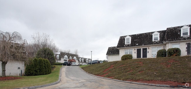

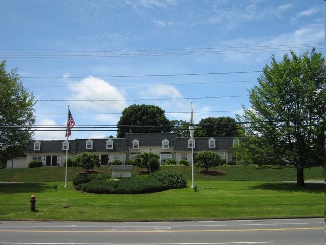
Property Detail
20 Easthampton Rd
HOLY-000144-000000-000019
Hampden
Apartment
Massachusetts
RM20
19
B and X Area of moderate flood hazard, usually the area between the limits of the 100-year and 500-year floods.
17.15 AC
2025
Holyoke
2025
Hartford
812002
Springfield, MA
161,190 SF
NEARBY LISTINGS FOR SALE OR LEASE
-
-
View all Holyoke listings for sale on LoopNet.com
DEMOGRAPHICS near 20 Easthampton Rd
1 mile
3 mile
5 mile
2025 Total Population
7,070
52,404
119,401
2030 Population
7,042
52,294
119,575
Pop Growth 2025-2030
(0.40%)
(0.21%)
+ 0.15%
Average Age
42
41
42
2025 Total Households
2,871
21,545
50,133
HH Growth 2025-2030
(0.42%)
(0.19%)
+ 0.21%
Median Household Inc
$70,127
$57,484
$64,590
Avg Household Size
2.30
2.30
2.30
2025 Avg HH Vehicles
2.00
1.00
2.00
Median Home Value
$323,050
$301,452
$299,861
Median Year Built
1948
1953
1960
Nearby Places
Map Layers
Map Styles
 Street
 Aerial
Layers
 Traffic
 Biking
Places
Listings with unknown addresses are not visible on the map
- Restaurants
- Banks
- Shops
- Fitness
- Groceries
PUBLIC TRANSPORTATION
COMMUTER RAIL
Holyoke Amtrak (Valley Flyer - Amtrak, Vermonter - Amtrak)
Drive
Walk
Distance
Holyoke Amtrak (Valley Flyer - Amtrak, Vermonter - Amtrak)
6 min
2.5 mi
Northampton (Valley Flyer - Amtrak, Vermonter - Amtrak)
Drive
Walk
Distance
Northampton (Valley Flyer - Amtrak, Vermonter - Amtrak)
14 min
9.7 mi
AIRPORT
Bradley International
Drive
Walk
Distance
Bradley International
43 min
21.9 mi
Freight Ports
Albany, NY Port
Drive
Walk
Distance
Albany, NY Port
103 min
83.9 mi
Nearby Properties
Address
Land Use
TOTAL SIZE
Lot Size
Zoning
Address
Land Use
TOTAL SIZE
Lot Size
Zoning
22.15 AC
R-1A
Address
Land Use
TOTAL SIZE
Lot Size
Zoning
189,022 SF
10.62 AC
RA
Address
Land Use
TOTAL SIZE
Lot Size
Zoning
17.72 AC
R-2
Address
Land Use
TOTAL SIZE
Lot Size
Zoning
12.90 AC
IP
Address
Land Use
TOTAL SIZE
Lot Size
Zoning
2.41 AC
DR
Address
Land Use
TOTAL SIZE
Lot Size
Zoning
8.16 AC
RM40
Address
Land Use
TOTAL SIZE
Lot Size
Zoning
72,239 SF
13.87 AC
R-1A
Address
Land Use
TOTAL SIZE
Lot Size
Zoning
23,111 SF
1.43 AC
IA
Address
Land Use
TOTAL SIZE
Lot Size
Zoning
138,289 SF
22.79 AC
IG
Address
Land Use
TOTAL SIZE
Lot Size
Zoning
196,705 SF
21.45 AC
RM20
Address
Land Use
TOTAL SIZE
Lot Size
Zoning
201,410 SF
13.16 AC
RM20
Address
Land Use
TOTAL SIZE
Lot Size
Zoning
191,133 SF
12.28 AC
RM-2
Address
Land Use
TOTAL SIZE
Lot Size
Zoning
62,808 SF
7.60 AC
R-1
Address
Land Use
TOTAL SIZE
Lot Size
Zoning
26.98 AC
BG
Address
Land Use
TOTAL SIZE
Lot Size
Zoning
194,875 SF
2.75 AC
IG
Address
Land Use
TOTAL SIZE
Lot Size
Zoning
64,638 SF
9.26 AC
RA2
Address
Land Use
TOTAL SIZE
Lot Size
Zoning
5.88 AC
IG
Address
Land Use
TOTAL SIZE
Lot Size
Zoning
43,289 SF
2.63 AC
DR
Address
Land Use
TOTAL SIZE
Lot Size
Zoning
77,702 SF
16.39 AC
RM20
Address
Land Use
TOTAL SIZE
Lot Size
Zoning
812,675 SF
19.64 AC
BH
Address
Land Use
TOTAL SIZE
Lot Size
Zoning
139,546 SF
8.84 AC
IG
Address
Land Use
TOTAL SIZE
Lot Size
Zoning
442 SF
0.85 AC
IG
Address
Land Use
TOTAL SIZE
Lot Size
Zoning
144,384 SF
35.87 AC
RA2
Address
Land Use
TOTAL SIZE
Lot Size
Zoning
2.61 AC
107
Address
Land Use
TOTAL SIZE
Lot Size
Zoning
2.77 AC
106
Address
Land Use
TOTAL SIZE
Lot Size
Zoning
17.68 AC
IGD
Address
Land Use
TOTAL SIZE
Lot Size
Zoning
54,354 SF
0.83 AC
105
Address
Land Use
TOTAL SIZE
Lot Size
Zoning
7.60 AC
BG
Address
Land Use
TOTAL SIZE
Lot Size
Zoning
6.28 AC
IG
The World's #1 Commercial Real Estate Marketplace
Connect with us
© 2026 CoStar Group
The information above has been obtained from sources believed reliable. While we do not doubt its accuracy we have not verified it and make no guarantee, warranty or representation about it. It is your responsibility to independently confirm its accuracy and completeness. Any projections, opinions, assumptions, or estimates used are for example only and do not represent the current or future performance of the property. The value of this transaction to you depends on tax and other factors which should be evaluated by your tax, financial, and legal advisors. You and your advisors should conduct a careful, independent investigation of the property to determine to your satisfaction the suitability of the property for your needs.