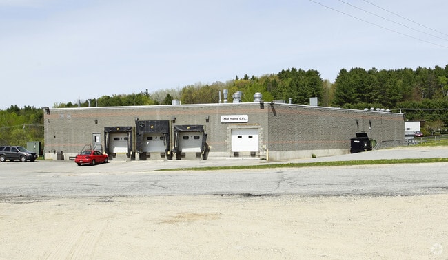
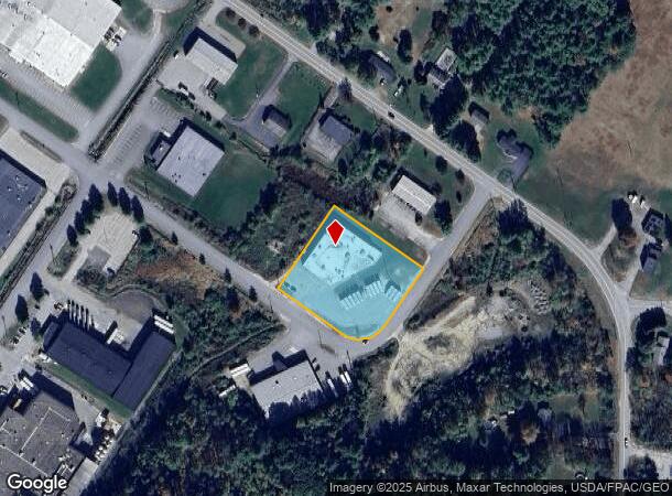
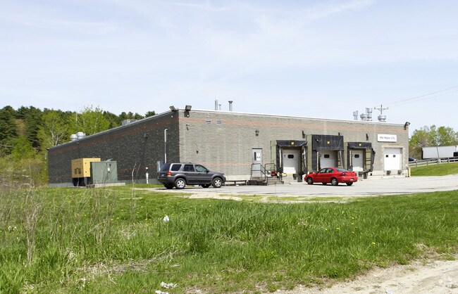
Property Record
20 Forrestal St, Lewiston, ME 04240
NEARBY LISTINGS FOR SALE OR LEASE
-
-
View all Lewiston listings for sale on LoopNet.com
Property Detail
20 Forrestal St
LEWI-000095-000000-000016
Androscoggin
Commercialbuilding
Maine
X
16
23001C0333E
1.55 AC
2025
Maine South & Augusta
2025
Other Market Areas
020802
Lewiston-Auburn, ME
17,796 SF
DEMOGRAPHICS near 20 Forrestal St
1 Mile
3 Mile
5 Mile
2024 Total Population
1,944
33,854
63,813
2029 Population
1,962
34,254
64,547
Pop Growth 2024-2029
+ 0.93%
+ 1.18%
+ 1.15%
Average Age
45
40
41
2024 Total Households
855
14,064
26,282
HH Growth 2024-2029
+ 1.05%
+ 1.12%
+ 1.09%
Median Household Inc
$77,833
$49,012
$53,037
Avg Household Size
2.20
2.20
2.20
2024 Avg HH Vehicles
2.00
1.00
2.00
Median Home Value
$199,281
$180,014
$198,079
Median Year Built
1972
1954
1956
Nearby Places
Map Layers
Map Styles
 Street
 Aerial
- Restaurants
- Banks
- Shops
- Fitness
- Groceries
Nearby Properties
Address
Land Use
TOTAL SIZE
Lot Size
Zoning
Address
Land Use
TOTAL SIZE
Lot Size
Zoning
542,760 SF
8.12 AC
Address
Land Use
TOTAL SIZE
Lot Size
Zoning
489,464 SF
117.19 AC
Address
Land Use
TOTAL SIZE
Lot Size
Zoning
7.76 AC
Address
Land Use
TOTAL SIZE
Lot Size
Zoning
Address
Land Use
TOTAL SIZE
Lot Size
Zoning
50,000 SF
86.08 AC
Address
Land Use
TOTAL SIZE
Lot Size
Zoning
49,842 SF
23 AC
Address
Land Use
TOTAL SIZE
Lot Size
Zoning
144,650 SF
16.19 AC
Address
Land Use
TOTAL SIZE
Lot Size
Zoning
67,873 SF
Address
Land Use
TOTAL SIZE
Lot Size
Zoning
106,600 SF
0.73 AC
Address
Land Use
TOTAL SIZE
Lot Size
Zoning
127,660 SF
9.24 AC
Address
Land Use
TOTAL SIZE
Lot Size
Zoning
27,606 SF
1.10 AC
Address
Land Use
TOTAL SIZE
Lot Size
Zoning
144,665 SF
36.25 AC
Address
Land Use
TOTAL SIZE
Lot Size
Zoning
125,449 SF
Address
Land Use
TOTAL SIZE
Lot Size
Zoning
94,914 SF
Address
Land Use
TOTAL SIZE
Lot Size
Zoning
187,994 SF
0.96 AC
Address
Land Use
TOTAL SIZE
Lot Size
Zoning
60,728 SF
0.86 AC
Address
Land Use
TOTAL SIZE
Lot Size
Zoning
136,901 SF
10.50 AC
Address
Land Use
TOTAL SIZE
Lot Size
Zoning
93.04 AC
Address
Land Use
TOTAL SIZE
Lot Size
Zoning
49,638 SF
0.76 AC
Address
Land Use
TOTAL SIZE
Lot Size
Zoning
96,073 SF
Address
Land Use
TOTAL SIZE
Lot Size
Zoning
22,184 SF
Address
Land Use
TOTAL SIZE
Lot Size
Zoning
66,622 SF
6.18 AC
Address
Land Use
TOTAL SIZE
Lot Size
Zoning
95,299 SF
67 AC
Address
Land Use
TOTAL SIZE
Lot Size
Zoning
185,466 SF
0.97 AC
Address
Land Use
TOTAL SIZE
Lot Size
Zoning
109,282 SF
20.80 AC
Address
Land Use
TOTAL SIZE
Lot Size
Zoning
33,954 SF
Address
Land Use
TOTAL SIZE
Lot Size
Zoning
2,306 SF
1.56 AC
Address
Land Use
TOTAL SIZE
Lot Size
Zoning
21.19 AC
Address
Land Use
TOTAL SIZE
Lot Size
Zoning
43,552 SF
1.42 AC
Address
Land Use
TOTAL SIZE
Lot Size
Zoning
133,040 SF
22.70 AC
The World's #1 Commercial Real Estate Marketplace
Connect with us
© 2025 CoStar Group
The information above has been obtained from sources believed reliable. While we do not doubt its accuracy we have not verified it and make no guarantee, warranty or representation about it. It is your responsibility to independently confirm its accuracy and completeness. Any projections, opinions, assumptions, or estimates used are for example only and do not represent the current or future performance of the property. The value of this transaction to you depends on tax and other factors which should be evaluated by your tax, financial, and legal advisors. You and your advisors should conduct a careful, independent investigation of the property to determine to your satisfaction the suitability of the property for your needs.