Property Record
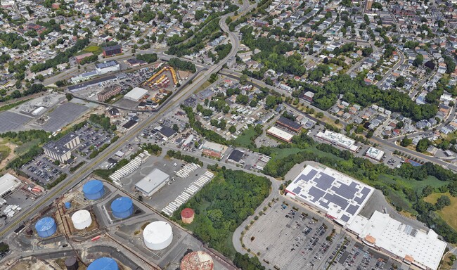
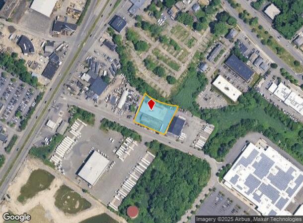
20 Furlong Dr, Revere, MA 02151
This Property Is For Sale
NEARBY LISTINGS FOR SALE OR LEASE
Property Detail
20 Furlong Dr
REVE-000006-000120B-000013
Suffolk
Commercialnec
Massachusetts
AE
13
25025C0019K
0.61 AC
2024
Chelsea/Revere
2025
Boston
170701
Boston-Cambridge-Newton, MA-NH
DEMOGRAPHICS near 20 Furlong Dr
1 Mile
3 Mile
5 Mile
2024 Total Population
30,334
190,183
477,058
2029 Population
28,061
177,916
459,006
Pop Growth 2024-2029
(7.49%)
(6.45%)
(3.78%)
Average Age
39
39
39
2024 Total Households
10,766
69,836
196,440
HH Growth 2024-2029
(7.92%)
(6.75%)
(3.69%)
Median Household Inc
$63,382
$72,149
$89,858
Avg Household Size
2.70
2.60
2.30
2024 Avg HH Vehicles
1.00
1.00
1.00
Median Home Value
$521,877
$549,272
$661,249
Median Year Built
1953
1949
1954
Nearby Places
Map Layers
Map Styles
 Street
 Aerial
- Restaurants
- Banks
- Shops
- Fitness
- Groceries
PUBLIC TRANSPORTATION
TRANSIT/SUBWAY
Beachmont Station (Blue Line - Massachusetts Bay Transportation Authority Subway (The T))
DRIVE
WALK
Distance
Beachmont Station (Blue Line - Massachusetts Bay Transportation Authority Subway (The T))
2 min
16 min
0.8 mi
Revere Beach Station (Blue Line - Massachusetts Bay Transportation Authority Subway (The T))
DRIVE
WALK
Distance
Revere Beach Station (Blue Line - Massachusetts Bay Transportation Authority Subway (The T))
3 min
20 min
1.1 mi
COMMUTER RAIL
DRIVE
WALK
Distance
8 min
3.4 mi
North Station (Fitchburg/South Acton Line - Massachusetts Bay Transportation Authority Commuter Rail (Purple Line), Haverhill Line - Massachusetts Bay Transportation Authority Commuter Rail (Purple Line), Lowell Line - Massachusetts Bay Transportation Authority Commuter Rail (Purple Line), Newburyport/Rockport Line - Massachusetts Bay Transportation Authority Commuter Rail (Purple Line))
DRIVE
WALK
Distance
North Station (Fitchburg/South Acton Line - Massachusetts Bay Transportation Authority Commuter Rail (Purple Line), Haverhill Line - Massachusetts Bay Transportation Authority Commuter Rail (Purple Line), Lowell Line - Massachusetts Bay Transportation Authority Commuter Rail (Purple Line), Newburyport/Rockport Line - Massachusetts Bay Transportation Authority Commuter Rail (Purple Line))
11 min
5.0 mi
AIRPORT
General Edward Lawrence Logan International
DRIVE
WALK
Distance
General Edward Lawrence Logan International
8 min
4.0 mi
Freight Ports
Port of Boston
DRIVE
WALK
Distance
Port of Boston
14 min
6.6 mi
Nearby Properties
Address
Land Use
TOTAL SIZE
Lot Size
Zoning
Address
Land Use
TOTAL SIZE
Lot Size
Zoning
171,791 SF
166.88 AC
E
Address
Land Use
TOTAL SIZE
Lot Size
Zoning
8 AC
HB
Address
Land Use
TOTAL SIZE
Lot Size
Zoning
410,642 SF
4.68 AC
CTED
Address
Land Use
TOTAL SIZE
Lot Size
Zoning
247,013 SF
1.13 AC
RC2
Address
Land Use
TOTAL SIZE
Lot Size
Zoning
234,450 SF
3.49 AC
I
Address
Land Use
TOTAL SIZE
Lot Size
Zoning
297,396 SF
2.79 AC
CTED
Address
Land Use
TOTAL SIZE
Lot Size
Zoning
424,000 SF
2.63 AC
RC
Address
Land Use
TOTAL SIZE
Lot Size
Zoning
378,339 SF
3.02 AC
E
Address
Land Use
TOTAL SIZE
Lot Size
Zoning
6.73 AC
HB
Address
Land Use
TOTAL SIZE
Lot Size
Zoning
211,294 SF
1.66 AC
RC2
Address
Land Use
TOTAL SIZE
Lot Size
Zoning
224,840 SF
2.18 AC
RC1
Address
Land Use
TOTAL SIZE
Lot Size
Zoning
129,898 SF
43.82 AC
ID
Address
Land Use
TOTAL SIZE
Lot Size
Zoning
226,431 SF
4.31 AC
HB
Address
Land Use
TOTAL SIZE
Lot Size
Zoning
359,892 SF
9.06 AC
Address
Land Use
TOTAL SIZE
Lot Size
Zoning
1.65 AC
RC2
Address
Land Use
TOTAL SIZE
Lot Size
Zoning
237,393 SF
7.15 AC
A
Address
Land Use
TOTAL SIZE
Lot Size
Zoning
6.02 AC
TED
Address
Land Use
TOTAL SIZE
Lot Size
Zoning
362,358 SF
3.44 AC
CTED
Address
Land Use
TOTAL SIZE
Lot Size
Zoning
379,857 SF
7.16 AC
R2
Address
Land Use
TOTAL SIZE
Lot Size
Zoning
65,072 SF
2.18 AC
E
Address
Land Use
TOTAL SIZE
Lot Size
Zoning
422,028 SF
16.10 AC
RB
Address
Land Use
TOTAL SIZE
Lot Size
Zoning
232,943 SF
3.87 AC
Address
Land Use
TOTAL SIZE
Lot Size
Zoning
227,673 SF
1.75 AC
R3
Address
Land Use
TOTAL SIZE
Lot Size
Zoning
172,043 SF
1.13 AC
RC1
Address
Land Use
TOTAL SIZE
Lot Size
Zoning
191,523 SF
2.70 AC
Address
Land Use
TOTAL SIZE
Lot Size
Zoning
5,668 SF
20.05 AC
A
Address
Land Use
TOTAL SIZE
Lot Size
Zoning
391,884 SF
108.79 AC
C
Address
Land Use
TOTAL SIZE
Lot Size
Zoning
738 SF
20.71 AC
PORT
Address
Land Use
TOTAL SIZE
Lot Size
Zoning
221,856 SF
17.82 AC
ID
Address
Land Use
TOTAL SIZE
Lot Size
Zoning
208,663 SF
2.56 AC
DD
The World's #1 Commercial Real Estate Marketplace
Connect with us
© 2026 CoStar Group
The information above has been obtained from sources believed reliable. While we do not doubt its accuracy we have not verified it and make no guarantee, warranty or representation about it. It is your responsibility to independently confirm its accuracy and completeness. Any projections, opinions, assumptions, or estimates used are for example only and do not represent the current or future performance of the property. The value of this transaction to you depends on tax and other factors which should be evaluated by your tax, financial, and legal advisors. You and your advisors should conduct a careful, independent investigation of the property to determine to your satisfaction the suitability of the property for your needs.