Property Record
20 Hawks Nest Plz, Saint Charles, MO 63303
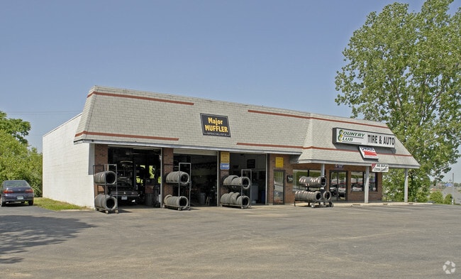

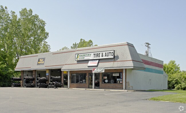
Property Detail
20 Hawks Nest Plz
6-010D-3280-00-0009.1000000
PT LOT 23 BLK 6 STEEN & CUNN SUBD
Commercialnec
Saint Charles
AB2
Missouri
B and X Area of moderate flood hazard, usually the area between the limits of the 100-year and 500-year floods.
23
2024
1.45 AC
2025
St Charles Region
310901
St. Louis
3,600 SF
St. Louis, MO-IL
NEARBY LISTINGS FOR SALE OR LEASE
DEMOGRAPHICS near 20 Hawks Nest Plz
1 mile
3 mile
5 mile
2025 Total Population
13,334
81,553
142,045
2030 Population
13,750
84,240
146,622
Pop Growth 2025-2030
+ 3.12%
+ 3.29%
+ 3.22%
Average Age
41
42
42
2025 Total Households
6,300
34,964
59,470
HH Growth 2025-2030
+ 3.27%
+ 3.49%
+ 3.41%
Median Household Inc
$67,468
$82,555
$87,267
Avg Household Size
2.00
2.20
2.30
2025 Avg HH Vehicles
2.00
2.00
2.00
Median Home Value
$243,284
$287,918
$285,368
Median Year Built
1980
1980
1984
Nearby Places
Map Layers
Map Styles
 Street
 Aerial
Layers
 Traffic
 Biking
Places
Listings with unknown addresses are not visible on the map
- Restaurants
- Banks
- Shops
- Fitness
- Groceries
PUBLIC TRANSPORTATION
AIRPORT
St Louis Lambert International
Drive
Walk
Distance
St Louis Lambert International
19 min
11.9 mi
Freight Ports
Port Milwaukee
Drive
Walk
Distance
Port Milwaukee
438 min
385.0 mi
Nearby Properties
Address
Land Use
TOTAL SIZE
Lot Size
Zoning
Address
Land Use
TOTAL SIZE
Lot Size
Zoning
2,918,475 SF
30.32 AC
AC1
Address
Land Use
TOTAL SIZE
Lot Size
Zoning
553,382 SF
109.67 AC
FPNU
Address
Land Use
TOTAL SIZE
Lot Size
Zoning
440,000 SF
2.11 AC
Address
Land Use
TOTAL SIZE
Lot Size
Zoning
581,756 SF
47.18 AC
AC2
Address
Land Use
TOTAL SIZE
Lot Size
Zoning
52,664 SF
13.59 AC
Address
Land Use
TOTAL SIZE
Lot Size
Zoning
201,270 SF
13.01 AC
Address
Land Use
TOTAL SIZE
Lot Size
Zoning
488,536 SF
23.53 AC
AF0
Address
Land Use
TOTAL SIZE
Lot Size
Zoning
281,074 SF
8.79 AC
Address
Land Use
TOTAL SIZE
Lot Size
Zoning
312,516 SF
2.18 AC
Address
Land Use
TOTAL SIZE
Lot Size
Zoning
120,050 SF
1.51 AC
Address
Land Use
TOTAL SIZE
Lot Size
Zoning
197,290 SF
29.28 AC
Address
Land Use
TOTAL SIZE
Lot Size
Zoning
87,027 SF
16.04 AC
AC4
Address
Land Use
TOTAL SIZE
Lot Size
Zoning
83.11 AC
AC9
Address
Land Use
TOTAL SIZE
Lot Size
Zoning
273,184 SF
20.05 AC
Address
Land Use
TOTAL SIZE
Lot Size
Zoning
273,398 SF
20.08 AC
AB2
Address
Land Use
TOTAL SIZE
Lot Size
Zoning
15,584 SF
50 AC
AC9
Address
Land Use
TOTAL SIZE
Lot Size
Zoning
316,064 SF
1.84 AC
Address
Land Use
TOTAL SIZE
Lot Size
Zoning
55.46 AC
AF0
Address
Land Use
TOTAL SIZE
Lot Size
Zoning
220,089 SF
25.47 AC
AA7
Address
Land Use
TOTAL SIZE
Lot Size
Zoning
100,633 SF
1.02 AC
Address
Land Use
TOTAL SIZE
Lot Size
Zoning
263,495 SF
20.10 AC
Address
Land Use
TOTAL SIZE
Lot Size
Zoning
320,000 SF
17.30 AC
FPM3
Address
Land Use
TOTAL SIZE
Lot Size
Zoning
199,216 SF
10.26 AC
Address
Land Use
TOTAL SIZE
Lot Size
Zoning
19,493 SF
3.01 AC
Address
Land Use
TOTAL SIZE
Lot Size
Zoning
63.61 AC
AC9
Address
Land Use
TOTAL SIZE
Lot Size
Zoning
41,256 SF
4.98 AC
Address
Land Use
TOTAL SIZE
Lot Size
Zoning
32,108 SF
0.90 AC
AF0
Address
Land Use
TOTAL SIZE
Lot Size
Zoning
388,768 SF
25.96 AC
FPM3
Address
Land Use
TOTAL SIZE
Lot Size
Zoning
260,584 SF
16.29 AC
Address
Land Use
TOTAL SIZE
Lot Size
Zoning
161,746 SF
16.18 AC
FPM3
The World's #1 Commercial Real Estate Marketplace
Connect with us
© 2026 CoStar Group
The information above has been obtained from sources believed reliable. While we do not doubt its accuracy we have not verified it and make no guarantee, warranty or representation about it. It is your responsibility to independently confirm its accuracy and completeness. Any projections, opinions, assumptions, or estimates used are for example only and do not represent the current or future performance of the property. The value of this transaction to you depends on tax and other factors which should be evaluated by your tax, financial, and legal advisors. You and your advisors should conduct a careful, independent investigation of the property to determine to your satisfaction the suitability of the property for your needs.