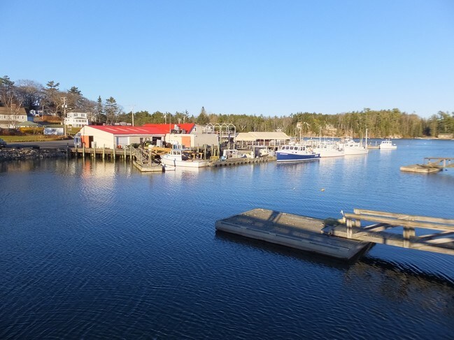
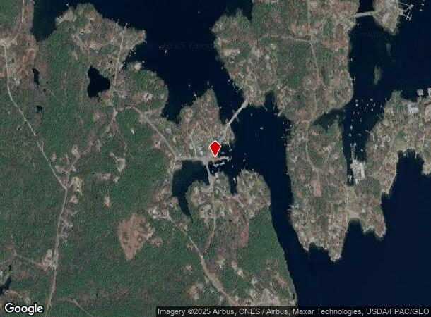
Property Record
20 Hendricks Hill Rd, Southport, ME 04576
NEARBY LISTINGS FOR SALE OR LEASE
-
-
View all Southport listings for sale on LoopNet.com
Property Detail
20 Hendricks Hill Rd
X
Lincoln
23015C0434D
Maine
2024
58
2024
Other Market Areas
976200
SPRT-000023-000000-000058
3,760 SF
Commercialbuilding
DEMOGRAPHICS near 20 Hendricks Hill Rd
1 Mile
3 Mile
5 Mile
2024 Total Population
405
3,813
6,999
2029 Population
424
4,155
7,540
Pop Growth 2024-2029
+ 4.69%
+ 8.97%
+ 7.73%
Average Age
53
55
54
2024 Total Households
201
1,988
3,496
HH Growth 2024-2029
+ 4.48%
+ 9.00%
+ 7.78%
Median Household Inc
$68,437
$61,692
$65,552
Avg Household Size
2.00
1.90
2.00
2024 Avg HH Vehicles
2.00
2.00
2.00
Median Home Value
$408,696
$379,278
$367,612
Median Year Built
1949
1965
1971
Nearby Places
Map Layers
Map Styles
 Street
 Aerial
- Restaurants
- Banks
- Shops
- Fitness
- Groceries
SALE & LEASE HISTORY
LISTING DATE
SALE/LEASE

Sep 24, 2016
For Sale
Nearby Properties
Address
Land Use
TOTAL SIZE
Lot Size
Zoning
Address
Land Use
TOTAL SIZE
Lot Size
Zoning
36,276 SF
29.82 AC
Address
Land Use
TOTAL SIZE
Lot Size
Zoning
47,384 SF
9 AC
Address
Land Use
TOTAL SIZE
Lot Size
Zoning
19,943 SF
12.75 AC
Address
Land Use
TOTAL SIZE
Lot Size
Zoning
83,920 SF
6 AC
Address
Land Use
TOTAL SIZE
Lot Size
Zoning
1,456 SF
5 AC
Address
Land Use
TOTAL SIZE
Lot Size
Zoning
43,372 SF
4 AC
Address
Land Use
TOTAL SIZE
Lot Size
Zoning
19,693 SF
Address
Land Use
TOTAL SIZE
Lot Size
Zoning
36,090 SF
Address
Land Use
TOTAL SIZE
Lot Size
Zoning
32,581 SF
15.50 AC
Address
Land Use
TOTAL SIZE
Lot Size
Zoning
2,496 SF
1.50 AC
Address
Land Use
TOTAL SIZE
Lot Size
Zoning
44,120 SF
5.04 AC
Address
Land Use
TOTAL SIZE
Lot Size
Zoning
16,156 SF
2 AC
Address
Land Use
TOTAL SIZE
Lot Size
Zoning
8,148 SF
1.23 AC
Address
Land Use
TOTAL SIZE
Lot Size
Zoning
4,684 SF
1.06 AC
Address
Land Use
TOTAL SIZE
Lot Size
Zoning
21,252 SF
1.16 AC
Address
Land Use
TOTAL SIZE
Lot Size
Zoning
12,426 SF
0.70 AC
Address
Land Use
TOTAL SIZE
Lot Size
Zoning
18,365 SF
0.57 AC
Address
Land Use
TOTAL SIZE
Lot Size
Zoning
34,476 SF
0.45 AC
Address
Land Use
TOTAL SIZE
Lot Size
Zoning
Address
Land Use
TOTAL SIZE
Lot Size
Zoning
1,964 SF
8.20 AC
Address
Land Use
TOTAL SIZE
Lot Size
Zoning
62.75 AC
Address
Land Use
TOTAL SIZE
Lot Size
Zoning
4,430 SF
30 AC
Address
Land Use
TOTAL SIZE
Lot Size
Zoning
9,314 SF
8 AC
Address
Land Use
TOTAL SIZE
Lot Size
Zoning
19.25 AC
SR/SZ
Address
Land Use
TOTAL SIZE
Lot Size
Zoning
18,860 SF
0.83 AC
Address
Land Use
TOTAL SIZE
Lot Size
Zoning
653 SF
2.55 AC
SR/SZ
Address
Land Use
TOTAL SIZE
Lot Size
Zoning
22,086 SF
6 AC
Address
Land Use
TOTAL SIZE
Lot Size
Zoning
15,930 SF
1 AC
Address
Land Use
TOTAL SIZE
Lot Size
Zoning
4,647 SF
1.92 AC
Address
Land Use
TOTAL SIZE
Lot Size
Zoning
572 SF
2.40 AC
SR/SZ
The World's #1 Commercial Real Estate Marketplace
Connect with us
© 2025 CoStar Group
The information above has been obtained from sources believed reliable. While we do not doubt its accuracy we have not verified it and make no guarantee, warranty or representation about it. It is your responsibility to independently confirm its accuracy and completeness. Any projections, opinions, assumptions, or estimates used are for example only and do not represent the current or future performance of the property. The value of this transaction to you depends on tax and other factors which should be evaluated by your tax, financial, and legal advisors. You and your advisors should conduct a careful, independent investigation of the property to determine to your satisfaction the suitability of the property for your needs.