Property Record
20 Kansas Rd, Naples, ME 04055

Save to a Folder
{{folder.Name}}
{{folder.ListingIds.length}} Properties
{{folder.ListingIds.length}} Property
Create a New Folder
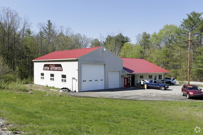
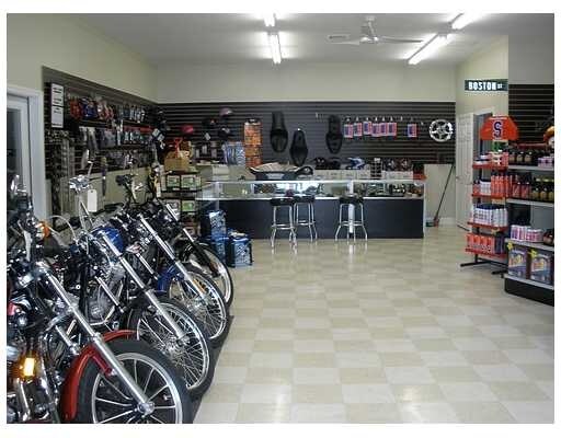
Property Detail
20 Kansas Rd
NAPL-000039U-000000-000003
Cumberland
Taxexempt
Maine
B and X Area of moderate flood hazard, usually the area between the limits of the 100-year and 500-year floods.
3
2025
1.04 AC
2025
SW Cumberland County
014002
Portland/South Portland
1,920 SF
Portland-South Portland, ME
NEARBY LISTINGS FOR SALE OR LEASE
-
-
View all Naples listings for sale on LoopNet.com
DEMOGRAPHICS near 20 Kansas Rd
1 mile
3 mile
5 mile
2025 Total Population
240
2,569
7,937
2030 Population
248
2,701
8,405
Pop Growth 2025-2030
+ 3.33%
+ 5.14%
+ 5.90%
Average Age
41
44
45
2025 Total Households
97
1,099
3,443
HH Growth 2025-2030
+ 3.09%
+ 5.46%
+ 6.16%
Median Household Inc
$68,999
$73,842
$78,361
Avg Household Size
2.50
2.30
2.30
2025 Avg HH Vehicles
2.00
2.00
2.00
Median Home Value
$250,000
$342,381
$371,633
Median Year Built
1988
1986
1985
Nearby Places
Map Layers
Map Styles
 Street
 Aerial
Layers
 Traffic
 Biking
Places
Listings with unknown addresses are not visible on the map
- Restaurants
- Banks
- Shops
- Fitness
- Groceries
PUBLIC TRANSPORTATION
AIRPORT
Portland International Jetport
Drive
Walk
Distance
Portland International Jetport
54 min
33.5 mi
Freight Ports
Portland, ME
Drive
Walk
Distance
Portland, ME
50 min
33.5 mi
SALE & LEASE HISTORY
LISTING DATE
SALE/LEASE

Sep 23, 2016
For Sale
Nearby Properties
Address
Land Use
TOTAL SIZE
Lot Size
Zoning
Address
Land Use
TOTAL SIZE
Lot Size
Zoning
Address
Land Use
TOTAL SIZE
Lot Size
Zoning
600 SF
78.22 AC
Address
Land Use
TOTAL SIZE
Lot Size
Zoning
1,764 SF
35.20 AC
Address
Land Use
TOTAL SIZE
Lot Size
Zoning
2.40 AC
Address
Land Use
TOTAL SIZE
Lot Size
Zoning
1,156 SF
6.30 AC
RES
Address
Land Use
TOTAL SIZE
Lot Size
Zoning
1,156 SF
6.30 AC
RES
Address
Land Use
TOTAL SIZE
Lot Size
Zoning
Address
Land Use
TOTAL SIZE
Lot Size
Zoning
2,956 SF
1.01 AC
RES
Address
Land Use
TOTAL SIZE
Lot Size
Zoning
0.40 AC
C/R
Address
Land Use
TOTAL SIZE
Lot Size
Zoning
1,840 SF
1 AC
Address
Land Use
TOTAL SIZE
Lot Size
Zoning
1,992 SF
1.50 AC
RES
Address
Land Use
TOTAL SIZE
Lot Size
Zoning
2,933 SF
7.20 AC
Address
Land Use
TOTAL SIZE
Lot Size
Zoning
1,593 SF
0.53 AC
Address
Land Use
TOTAL SIZE
Lot Size
Zoning
792 SF
0.98 AC
C/R
Address
Land Use
TOTAL SIZE
Lot Size
Zoning
1,744 SF
0.87 AC
MBL
Address
Land Use
TOTAL SIZE
Lot Size
Zoning
975 SF
1.79 AC
Address
Land Use
TOTAL SIZE
Lot Size
Zoning
1,444 SF
1.48 AC
RES
Address
Land Use
TOTAL SIZE
Lot Size
Zoning
1,300 SF
0.76 AC
RES
Address
Land Use
TOTAL SIZE
Lot Size
Zoning
924 SF
3.05 AC
Address
Land Use
TOTAL SIZE
Lot Size
Zoning
1,506 SF
0.74 AC
RES
Address
Land Use
TOTAL SIZE
Lot Size
Zoning
396 SF
0.95 AC
RES
Address
Land Use
TOTAL SIZE
Lot Size
Zoning
1,200 SF
0.96 AC
RES
Address
Land Use
TOTAL SIZE
Lot Size
Zoning
1,904 SF
1.93 AC
RES
Address
Land Use
TOTAL SIZE
Lot Size
Zoning
576 SF
1.40 AC
RES
Address
Land Use
TOTAL SIZE
Lot Size
Zoning
720 SF
11.36 AC
Address
Land Use
TOTAL SIZE
Lot Size
Zoning
5.74 AC
Address
Land Use
TOTAL SIZE
Lot Size
Zoning
Address
Land Use
TOTAL SIZE
Lot Size
Zoning
504 SF
0.78 AC
RES
Address
Land Use
TOTAL SIZE
Lot Size
Zoning
1,476 SF
0.67 AC
Address
Land Use
TOTAL SIZE
Lot Size
Zoning
1,200 SF
1 AC
The World's #1 Commercial Real Estate Marketplace
Connect with us
© 2026 CoStar Group
The information above has been obtained from sources believed reliable. While we do not doubt its accuracy we have not verified it and make no guarantee, warranty or representation about it. It is your responsibility to independently confirm its accuracy and completeness. Any projections, opinions, assumptions, or estimates used are for example only and do not represent the current or future performance of the property. The value of this transaction to you depends on tax and other factors which should be evaluated by your tax, financial, and legal advisors. You and your advisors should conduct a careful, independent investigation of the property to determine to your satisfaction the suitability of the property for your needs.