Property Record
20 Lone St, Marshfield, MA 02050

Save to a Folder
{{folder.Name}}
{{folder.ListingIds.length}} Properties
{{folder.ListingIds.length}} Property
Create a New Folder
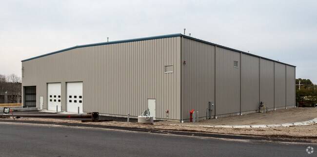
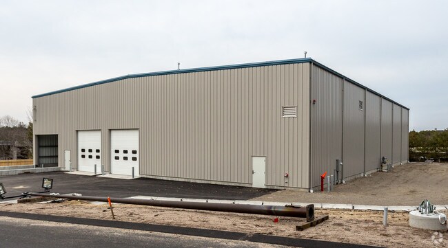
Property Detail
20 Lone St
C10-01-05A
Plymouth
Commercialbuilding
Massachusetts
I-1
5a
B and X Area of moderate flood hazard, usually the area between the limits of the 100-year and 500-year floods.
0.97 AC
2025
Route 3 South
2025
Boston
506102
Boston-Cambridge-Newton, MA-NH
14,256 SF
NEARBY LISTINGS FOR SALE OR LEASE
DEMOGRAPHICS near 20 Lone St
1 mile
3 mile
5 mile
2025 Total Population
3,551
17,803
55,372
2030 Population
3,644
18,093
56,323
Pop Growth 2025-2030
+ 2.62%
+ 1.63%
+ 1.72%
Average Age
44
43
43
2025 Total Households
1,505
6,705
20,346
HH Growth 2025-2030
+ 2.92%
+ 1.76%
+ 1.78%
Median Household Inc
$86,029
$133,049
$141,320
Avg Household Size
2.30
2.60
2.70
2025 Avg HH Vehicles
2.00
2.00
2.00
Median Home Value
$740,605
$747,218
$751,254
Median Year Built
1991
1978
1975
Nearby Places
Map Layers
Map Styles
 Street
 Aerial
Layers
 Traffic
 Biking
Places
Listings with unknown addresses are not visible on the map
- Restaurants
- Banks
- Shops
- Fitness
- Groceries
PUBLIC TRANSPORTATION
COMMUTER RAIL
Greenbush (Greenbush Line - Massachusetts Bay Transportation Authority Commuter Rail (Purple Line))
Drive
Walk
Distance
Greenbush (Greenbush Line - Massachusetts Bay Transportation Authority Commuter Rail (Purple Line))
12 min
6.5 mi
Halifax (Kingston/Plymouth Line - Massachusetts Bay Transportation Authority Commuter Rail (Purple Line))
Drive
Walk
Distance
Halifax (Kingston/Plymouth Line - Massachusetts Bay Transportation Authority Commuter Rail (Purple Line))
18 min
9.5 mi
AIRPORT
General Edward Lawrence Logan International
Drive
Walk
Distance
General Edward Lawrence Logan International
42 min
29.0 mi
Freight Ports
Port of Boston
Drive
Walk
Distance
Port of Boston
39 min
26.9 mi
Nearby Properties
Address
Land Use
TOTAL SIZE
Lot Size
Zoning
Address
Land Use
TOTAL SIZE
Lot Size
Zoning
322,940 SF
21.19 AC
I-1
Address
Land Use
TOTAL SIZE
Lot Size
Zoning
178,072 SF
9.11 AC
I-1
Address
Land Use
TOTAL SIZE
Lot Size
Zoning
279,792 SF
51 AC
Address
Land Use
TOTAL SIZE
Lot Size
Zoning
236,855 SF
33.47 AC
Address
Land Use
TOTAL SIZE
Lot Size
Zoning
182,609 SF
24.63 AC
Address
Land Use
TOTAL SIZE
Lot Size
Zoning
110,942 SF
2.11 AC
Address
Land Use
TOTAL SIZE
Lot Size
Zoning
220,150 SF
15.73 AC
Address
Land Use
TOTAL SIZE
Lot Size
Zoning
12,180 SF
10.80 AC
I-1
Address
Land Use
TOTAL SIZE
Lot Size
Zoning
136,577 SF
17.63 AC
Address
Land Use
TOTAL SIZE
Lot Size
Zoning
29,662 SF
3.98 AC
Address
Land Use
TOTAL SIZE
Lot Size
Zoning
92,781 SF
27.94 AC
B-2
Address
Land Use
TOTAL SIZE
Lot Size
Zoning
50,341 SF
7.05 AC
I-1
Address
Land Use
TOTAL SIZE
Lot Size
Zoning
44,189 SF
10.87 AC
Address
Land Use
TOTAL SIZE
Lot Size
Zoning
61,926 SF
27.89 AC
Address
Land Use
TOTAL SIZE
Lot Size
Zoning
40,084 SF
12.80 AC
B-2
Address
Land Use
TOTAL SIZE
Lot Size
Zoning
7,408 SF
132.85 AC
RC
Address
Land Use
TOTAL SIZE
Lot Size
Zoning
23.31 AC
B
Address
Land Use
TOTAL SIZE
Lot Size
Zoning
22,173 SF
62.99 AC
Address
Land Use
TOTAL SIZE
Lot Size
Zoning
47,346 SF
6.30 AC
R-1
Address
Land Use
TOTAL SIZE
Lot Size
Zoning
70,233 SF
11.89 AC
R-2
Address
Land Use
TOTAL SIZE
Lot Size
Zoning
55,870 SF
129.15 AC
Address
Land Use
TOTAL SIZE
Lot Size
Zoning
45,696 SF
2.76 AC
Address
Land Use
TOTAL SIZE
Lot Size
Zoning
45,696 SF
5.36 AC
Address
Land Use
TOTAL SIZE
Lot Size
Zoning
94,700 SF
10.95 AC
Address
Land Use
TOTAL SIZE
Lot Size
Zoning
50,870 SF
6.24 AC
Address
Land Use
TOTAL SIZE
Lot Size
Zoning
88,420 SF
4.80 AC
I-1
Address
Land Use
TOTAL SIZE
Lot Size
Zoning
40,272 SF
1.33 AC
B-1
Address
Land Use
TOTAL SIZE
Lot Size
Zoning
43,620 SF
7.50 AC
B
Address
Land Use
TOTAL SIZE
Lot Size
Zoning
55,750 SF
5 AC
Address
Land Use
TOTAL SIZE
Lot Size
Zoning
103,668 SF
1.98 AC
The World's #1 Commercial Real Estate Marketplace
Connect with us
© 2026 CoStar Group
The information above has been obtained from sources believed reliable. While we do not doubt its accuracy we have not verified it and make no guarantee, warranty or representation about it. It is your responsibility to independently confirm its accuracy and completeness. Any projections, opinions, assumptions, or estimates used are for example only and do not represent the current or future performance of the property. The value of this transaction to you depends on tax and other factors which should be evaluated by your tax, financial, and legal advisors. You and your advisors should conduct a careful, independent investigation of the property to determine to your satisfaction the suitability of the property for your needs.