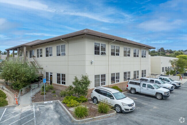
Property Record
20 Lower Ragsdale Dr, Monterey, CA 93940


NEARBY LISTINGS FOR SALE OR LEASE
Property Detail
20 Lower Ragsdale Dr
Salinas, CA
Ryan Ranch Industrial Park Unit 2, Track
259-031-074-000
RYAN RANCH INDUSTRIAL PARK UNIT 2, TRACK 961, LOT 9, EXC POR DES IN R2218-351 AND EXC POR DESC IN DOC # 2011008776
Industrialpark
Monterey
A
California
06053C0333G
9
2024
3.10 AC
2025
North Monterey County
013200
Salinas
26,694 SF
DEMOGRAPHICS near 20 Lower Ragsdale Dr
1 Mile
3 Mile
5 Mile
2024 Total Population
239
21,668
59,611
2029 Population
240
21,543
59,537
Pop Growth 2024-2029
+ 0.42%
(0.58%)
(0.12%)
Average Age
53
42
41
2024 Total Households
97
7,768
22,331
HH Growth 2024-2029
+ 1.03%
(0.81%)
(0.43%)
Median Household Inc
$209,804
$91,131
$90,246
Avg Household Size
2.40
2.70
2.60
2024 Avg HH Vehicles
3.00
2.00
2.00
Median Home Value
$1,114,583
$792,954
$845,307
Median Year Built
1995
1966
1971
Nearby Places
Map Layers
Map Styles
 Street
 Aerial
- Restaurants
- Banks
- Shops
- Fitness
- Groceries
PUBLIC TRANSPORTATION
AIRPORT
Monterey Regional
DRIVE
WALK
Distance
Monterey Regional
6 min
2.9 mi
SALE & LEASE HISTORY
LISTING DATE
SALE/LEASE

May 02, 2018
For Sale
Nearby Properties
Address
Land Use
TOTAL SIZE
Lot Size
Zoning
Address
Land Use
TOTAL SIZE
Lot Size
Zoning
6,464 SF
8.86 AC
Address
Land Use
TOTAL SIZE
Lot Size
Zoning
Address
Land Use
TOTAL SIZE
Lot Size
Zoning
2.41 AC
Address
Land Use
TOTAL SIZE
Lot Size
Zoning
58,125 SF
0.99 AC
Address
Land Use
TOTAL SIZE
Lot Size
Zoning
59,000 SF
5.63 AC
Address
Land Use
TOTAL SIZE
Lot Size
Zoning
32,824 SF
3.07 AC
Address
Land Use
TOTAL SIZE
Lot Size
Zoning
75,344 SF
2.83 AC
Address
Land Use
TOTAL SIZE
Lot Size
Zoning
10.42 AC
Address
Land Use
TOTAL SIZE
Lot Size
Zoning
25,312 SF
1.22 AC
Address
Land Use
TOTAL SIZE
Lot Size
Zoning
9.73 AC
Address
Land Use
TOTAL SIZE
Lot Size
Zoning
49,920 SF
7.23 AC
Address
Land Use
TOTAL SIZE
Lot Size
Zoning
Address
Land Use
TOTAL SIZE
Lot Size
Zoning
1.13 AC
Address
Land Use
TOTAL SIZE
Lot Size
Zoning
36,640 SF
19.59 AC
Address
Land Use
TOTAL SIZE
Lot Size
Zoning
19,199 SF
6 AC
Address
Land Use
TOTAL SIZE
Lot Size
Zoning
14,456 SF
2.50 AC
Address
Land Use
TOTAL SIZE
Lot Size
Zoning
18,329 SF
1 AC
Address
Land Use
TOTAL SIZE
Lot Size
Zoning
26,303 SF
0.64 AC
Address
Land Use
TOTAL SIZE
Lot Size
Zoning
45,240 SF
1.86 AC
Address
Land Use
TOTAL SIZE
Lot Size
Zoning
0.85 AC
Address
Land Use
TOTAL SIZE
Lot Size
Zoning
30,460 SF
0.99 AC
Address
Land Use
TOTAL SIZE
Lot Size
Zoning
43,663 SF
3.49 AC
Address
Land Use
TOTAL SIZE
Lot Size
Zoning
63,880 SF
6.29 AC
Address
Land Use
TOTAL SIZE
Lot Size
Zoning
Address
Land Use
TOTAL SIZE
Lot Size
Zoning
9.92 AC
Address
Land Use
TOTAL SIZE
Lot Size
Zoning
28,316 SF
0.56 AC
Address
Land Use
TOTAL SIZE
Lot Size
Zoning
26,987 SF
1.20 AC
Address
Land Use
TOTAL SIZE
Lot Size
Zoning
33,176 SF
1.53 AC
Address
Land Use
TOTAL SIZE
Lot Size
Zoning
28,536 SF
1.22 AC
Address
Land Use
TOTAL SIZE
Lot Size
Zoning
174 SF
6.93 AC
The World's #1 Commercial Real Estate Marketplace
Connect with us
© 2026 CoStar Group
The information above has been obtained from sources believed reliable. While we do not doubt its accuracy we have not verified it and make no guarantee, warranty or representation about it. It is your responsibility to independently confirm its accuracy and completeness. Any projections, opinions, assumptions, or estimates used are for example only and do not represent the current or future performance of the property. The value of this transaction to you depends on tax and other factors which should be evaluated by your tax, financial, and legal advisors. You and your advisors should conduct a careful, independent investigation of the property to determine to your satisfaction the suitability of the property for your needs.