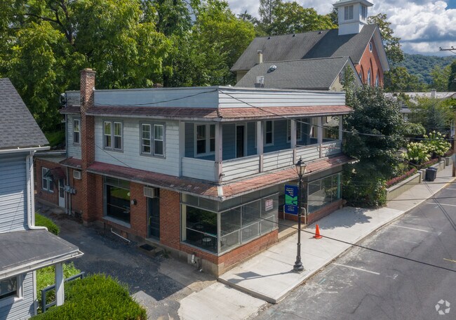
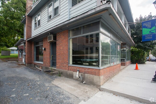
Property Record
14 Main St, Delaware Water Gap, PA 18327
NEARBY LISTINGS FOR SALE OR LEASE
Property Detail
14 Main St
East Stroudsburg, PA
Monroe
04.2.3.10
Pennsylvania
Duplex
0.55 AC
X
Monroe County
42095C0035E
Philadelphia
2,690 SF
DEMOGRAPHICS near 14 Main St
1 Mile
3 Mile
5 Mile
2024 Total Population
542
14,414
34,282
2029 Population
488
14,070
33,762
Pop Growth 2024-2029
(9.96%)
(2.39%)
(1.52%)
Average Age
46
39
41
2024 Total Households
238
5,265
12,961
HH Growth 2024-2029
(10.08%)
(2.03%)
(1.33%)
Median Household Inc
$77,083
$69,096
$74,758
Avg Household Size
2.30
2.30
2.50
2024 Avg HH Vehicles
2.00
2.00
2.00
Median Home Value
$293,616
$228,663
$249,077
Median Year Built
1972
1964
1975
Nearby Places
- Restaurants
- Banks
- Shops
- Fitness
- Groceries
PUBLIC TRANSPORTATION
AIRPORT
Lehigh Valley International
DRIVE
WALK
Distance
Lehigh Valley International
55 min
36.1 mi
Freight Ports
Maher Terminal
DRIVE
WALK
Distance
Maher Terminal
84 min
67.4 mi
SALE & LEASE HISTORY
LISTING DATE
SALE/LEASE

Oct 28, 2019
For Lease
Nearby Properties
Address
Land Use
TOTAL SIZE
Lot Size
Zoning
Address
Land Use
TOTAL SIZE
Lot Size
Zoning
260,728 SF
23.15 AC
IU
Address
Land Use
TOTAL SIZE
Lot Size
Zoning
225,935 SF
3.74 AC
IM
Address
Land Use
TOTAL SIZE
Lot Size
Zoning
102,240 SF
34.13 AC
R-2
Address
Land Use
TOTAL SIZE
Lot Size
Zoning
254,320 SF
0.23 AC
IU
Address
Land Use
TOTAL SIZE
Lot Size
Zoning
16,664 SF
43.49 AC
R2
Address
Land Use
TOTAL SIZE
Lot Size
Zoning
48,796 SF
5.69 AC
C-1A
Address
Land Use
TOTAL SIZE
Lot Size
Zoning
91,431 SF
Address
Land Use
TOTAL SIZE
Lot Size
Zoning
112,582 SF
26.38 AC
B2
Address
Land Use
TOTAL SIZE
Lot Size
Zoning
4,769.70 AC
P
Address
Land Use
TOTAL SIZE
Lot Size
Zoning
140,177 SF
16.16 AC
C-1
Address
Land Use
TOTAL SIZE
Lot Size
Zoning
129,257 SF
1.92 AC
IU
Address
Land Use
TOTAL SIZE
Lot Size
Zoning
126,740 SF
1.67 AC
IU
Address
Land Use
TOTAL SIZE
Lot Size
Zoning
90,072 SF
3.15 AC
IU
Address
Land Use
TOTAL SIZE
Lot Size
Zoning
20,984 SF
14.30 AC
I-E
Address
Land Use
TOTAL SIZE
Lot Size
Zoning
201,578 SF
21.19 AC
OM-1
Address
Land Use
TOTAL SIZE
Lot Size
Zoning
83,103 SF
30.80 AC
IU
Address
Land Use
TOTAL SIZE
Lot Size
Zoning
47,628 SF
4.40 AC
C1
Address
Land Use
TOTAL SIZE
Lot Size
Zoning
34,352 SF
9.83 AC
C1
Address
Land Use
TOTAL SIZE
Lot Size
Zoning
113,052 SF
1.56 AC
C-2
Address
Land Use
TOTAL SIZE
Lot Size
Zoning
179,576 SF
1.76 AC
C-2
Address
Land Use
TOTAL SIZE
Lot Size
Zoning
8,740 SF
9.25 AC
R-2
Address
Land Use
TOTAL SIZE
Lot Size
Zoning
52,322 SF
2.93 AC
C-2
Address
Land Use
TOTAL SIZE
Lot Size
Zoning
30,622 SF
3.55 AC
C1
Address
Land Use
TOTAL SIZE
Lot Size
Zoning
72,774 SF
4.26 AC
R-1
Address
Land Use
TOTAL SIZE
Lot Size
Zoning
60,828 SF
1.18 AC
IU
Address
Land Use
TOTAL SIZE
Lot Size
Zoning
97,438 SF
2.27 AC
IM
Address
Land Use
TOTAL SIZE
Lot Size
Zoning
68,640 SF
0.17 AC
IU
Address
Land Use
TOTAL SIZE
Lot Size
Zoning
31,978 SF
18.89 AC
IU
Address
Land Use
TOTAL SIZE
Lot Size
Zoning
5,312 SF
922 AC
FPD
Address
Land Use
TOTAL SIZE
Lot Size
Zoning
67,584 SF
1.98 AC
IU
The World's #1 Commercial Real Estate Marketplace
Connect with us
© 2025 CoStar Group
The information above has been obtained from sources believed reliable. While we do not doubt its accuracy we have not verified it and make no guarantee, warranty or representation about it. It is your responsibility to independently confirm its accuracy and completeness. Any projections, opinions, assumptions, or estimates used are for example only and do not represent the current or future performance of the property. The value of this transaction to you depends on tax and other factors which should be evaluated by your tax, financial, and legal advisors. You and your advisors should conduct a careful, independent investigation of the property to determine to your satisfaction the suitability of the property for your needs.