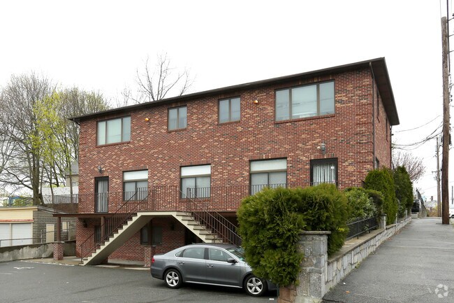
Property Record
20 Mill St, Cumberland, RI 02864


Property Detail
20 Mill St
Commercialofficeresidentialmixeduse
Providence
40
Rhode Island
B and X Area of moderate flood hazard, usually the area between the limits of the 100-year and 500-year floods.
0.22 AC
2025
Lincoln
2025
Providence
011200
Providence-Warwick, RI-MA
5,387 SF
CUMB-000002-000201-000000
NEARBY LISTINGS FOR SALE OR LEASE
DEMOGRAPHICS near 20 Mill St
1 mile
3 mile
5 mile
2025 Total Population
21,881
133,237
256,463
2030 Population
22,094
136,347
263,754
Pop Growth 2025-2030
+ 0.97%
+ 2.33%
+ 2.84%
Average Age
38
39
40
2025 Total Households
8,085
52,830
103,792
HH Growth 2025-2030
+ 1.01%
+ 2.34%
+ 2.89%
Median Household Inc
$59,752
$72,137
$79,002
Avg Household Size
2.60
2.40
2.40
2025 Avg HH Vehicles
1.00
2.00
2.00
Median Home Value
$346,117
$357,515
$393,742
Median Year Built
1952
1952
1956
Nearby Places
Map Layers
Map Styles
 Street
 Aerial
Transit
 Traffic
 Biking
Places
Listings with unknown addresses are not visible on the map
- Restaurants
- Banks
- Shops
- Fitness
- Groceries
PUBLIC TRANSPORTATION
COMMUTER RAIL
Drive
Walk
Distance
3 min
1.7 mi
South Attleboro (Providence/Stoughton Line - Massachusetts Bay Transportation Authority Commuter Rail (Purple Line))
Drive
Walk
Distance
South Attleboro (Providence/Stoughton Line - Massachusetts Bay Transportation Authority Commuter Rail (Purple Line))
6 min
2.3 mi
AIRPORT
Rhode Island Tf Green International
Drive
Walk
Distance
Rhode Island Tf Green International
27 min
14.8 mi
Worcester Regional
Drive
Walk
Distance
Worcester Regional
58 min
41.9 mi
General Edward Lawrence Logan International
Drive
Walk
Distance
General Edward Lawrence Logan International
63 min
42.8 mi
Freight Ports
Port of Davisville, RI
Drive
Walk
Distance
Port of Davisville, RI
43 min
27.2 mi
Nearby Properties
Address
Land Use
TOTAL SIZE
Lot Size
Zoning
Address
Land Use
TOTAL SIZE
Lot Size
Zoning
170,531 SF
3 AC
M-2
Address
Land Use
TOTAL SIZE
Lot Size
Zoning
28,208 SF
38.19 AC
PHB
Address
Land Use
TOTAL SIZE
Lot Size
Zoning
168,150 SF
2.77 AC
PO
Address
Land Use
TOTAL SIZE
Lot Size
Zoning
21 AC
RM
Address
Land Use
TOTAL SIZE
Lot Size
Zoning
134,113 SF
0.74 AC
RM
Address
Land Use
TOTAL SIZE
Lot Size
Zoning
96,300 SF
3.79 AC
RM
Address
Land Use
TOTAL SIZE
Lot Size
Zoning
4.45 AC
RM
Address
Land Use
TOTAL SIZE
Lot Size
Zoning
312,784 SF
11.53 AC
MO
Address
Land Use
TOTAL SIZE
Lot Size
Zoning
14,841 SF
15.70 AC
PHB
Address
Land Use
TOTAL SIZE
Lot Size
Zoning
88,698 SF
1.44 AC
RM
Address
Land Use
TOTAL SIZE
Lot Size
Zoning
109,700 SF
3.73 AC
RT
Address
Land Use
TOTAL SIZE
Lot Size
Zoning
14.66 AC
CG
Address
Land Use
TOTAL SIZE
Lot Size
Zoning
10,920 SF
11.03 AC
Address
Land Use
TOTAL SIZE
Lot Size
Zoning
214,701 SF
3.14 AC
RE
Address
Land Use
TOTAL SIZE
Lot Size
Zoning
2.97 AC
MB
Address
Land Use
TOTAL SIZE
Lot Size
Zoning
55,103 SF
2.98 AC
RT
Address
Land Use
TOTAL SIZE
Lot Size
Zoning
147,170 SF
2.23 AC
R-3
Address
Land Use
TOTAL SIZE
Lot Size
Zoning
15,086 SF
2.61 AC
C-2
Address
Land Use
TOTAL SIZE
Lot Size
Zoning
97,858 SF
2.02 AC
R-3
Address
Land Use
TOTAL SIZE
Lot Size
Zoning
98,968 SF
1.66 AC
R-2
Address
Land Use
TOTAL SIZE
Lot Size
Zoning
189,308 SF
19.76 AC
I
Address
Land Use
TOTAL SIZE
Lot Size
Zoning
85,626 SF
2.22 AC
RT
Address
Land Use
TOTAL SIZE
Lot Size
Zoning
155,731 SF
41.03 AC
PHB
Address
Land Use
TOTAL SIZE
Lot Size
Zoning
2.23 AC
RE
Address
Land Use
TOTAL SIZE
Lot Size
Zoning
69,053 SF
0.87 AC
C-2
Address
Land Use
TOTAL SIZE
Lot Size
Zoning
27,264 SF
6.20 AC
Address
Land Use
TOTAL SIZE
Lot Size
Zoning
146,404 SF
2.12 AC
MB
Address
Land Use
TOTAL SIZE
Lot Size
Zoning
46,521 SF
23.19 AC
PO
Address
Land Use
TOTAL SIZE
Lot Size
Zoning
97,027 SF
12.02 AC
C60
Address
Land Use
TOTAL SIZE
Lot Size
Zoning
6 AC
120
The World's #1 Commercial Real Estate Marketplace
Connect with us
© 2026 CoStar Group
The information above has been obtained from sources believed reliable. While we do not doubt its accuracy we have not verified it and make no guarantee, warranty or representation about it. It is your responsibility to independently confirm its accuracy and completeness. Any projections, opinions, assumptions, or estimates used are for example only and do not represent the current or future performance of the property. The value of this transaction to you depends on tax and other factors which should be evaluated by your tax, financial, and legal advisors. You and your advisors should conduct a careful, independent investigation of the property to determine to your satisfaction the suitability of the property for your needs.