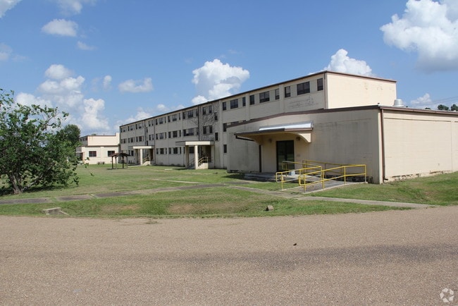
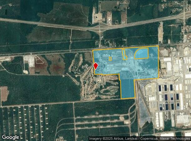
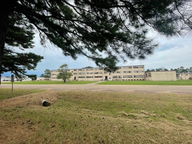
Property Record
20 N Circle Dr, New Boston, TX 75570
NEARBY LISTINGS FOR SALE OR LEASE
Property Detail
20 N Circle Dr
04340007100
Jonathan Collum A-109
Taxexempt
JONATHAN COLLUM A-109 5933/82 10/29/10 BLK/TRACT 50 50A 279.97 ACRES
X
Bowie
48037C0305D
Texas
0
279.97 AC
2025
Texas East Area
011302
Other Market Areas
262,312 SF
Texarkana, TX-AR
DEMOGRAPHICS near 20 N Circle Dr
1 Mile
3 Mile
5 Mile
2024 Total Population
132
1,597
5,688
2029 Population
125
1,544
5,582
Pop Growth 2024-2029
(5.30%)
(3.32%)
(1.86%)
Average Age
45
40
40
2024 Total Households
56
677
2,326
HH Growth 2024-2029
(5.36%)
(3.40%)
(1.93%)
Median Household Inc
$47,500
$53,197
$52,174
Avg Household Size
2.30
2.40
2.40
2024 Avg HH Vehicles
3.00
2.00
2.00
Median Home Value
$125,000
$111,582
$104,677
Median Year Built
1980
1979
1975
Nearby Places
Map Layers
Map Styles
 Street
 Aerial
- Restaurants
- Banks
- Shops
- Fitness
- Groceries
PUBLIC TRANSPORTATION
AIRPORT
Texarkana Regional-Webb Field
DRIVE
WALK
Distance
Texarkana Regional-Webb Field
34 min
24.4 mi
Freight Ports
Port of Shreveport
DRIVE
WALK
Distance
Port of Shreveport
128 min
112.4 mi
SALE & LEASE HISTORY
LISTING DATE
SALE/LEASE

Mar 27, 2019
For Lease
Nearby Properties
Address
Land Use
TOTAL SIZE
Lot Size
Zoning
Address
Land Use
TOTAL SIZE
Lot Size
Zoning
153,941 SF
123.92 AC
Address
Land Use
TOTAL SIZE
Lot Size
Zoning
27,000 SF
13.80 AC
Address
Land Use
TOTAL SIZE
Lot Size
Zoning
834.91 AC
Address
Land Use
TOTAL SIZE
Lot Size
Zoning
55,000 SF
8.24 AC
Address
Land Use
TOTAL SIZE
Lot Size
Zoning
40,514 SF
18.33 AC
Address
Land Use
TOTAL SIZE
Lot Size
Zoning
79,784 SF
10 AC
Address
Land Use
TOTAL SIZE
Lot Size
Zoning
222.63 AC
Address
Land Use
TOTAL SIZE
Lot Size
Zoning
9,114 SF
6.76 AC
Address
Land Use
TOTAL SIZE
Lot Size
Zoning
26,684 SF
22.52 AC
Address
Land Use
TOTAL SIZE
Lot Size
Zoning
38,048 SF
4.06 AC
Address
Land Use
TOTAL SIZE
Lot Size
Zoning
19,600 SF
2.40 AC
Address
Land Use
TOTAL SIZE
Lot Size
Zoning
10,416 SF
1.19 AC
Address
Land Use
TOTAL SIZE
Lot Size
Zoning
110.40 AC
Address
Land Use
TOTAL SIZE
Lot Size
Zoning
19,669 SF
18.20 AC
Address
Land Use
TOTAL SIZE
Lot Size
Zoning
10,152 SF
1.27 AC
Address
Land Use
TOTAL SIZE
Lot Size
Zoning
9,012 SF
1.44 AC
Address
Land Use
TOTAL SIZE
Lot Size
Zoning
37,920 SF
1.62 AC
Address
Land Use
TOTAL SIZE
Lot Size
Zoning
5,550 SF
210.88 AC
Address
Land Use
TOTAL SIZE
Lot Size
Zoning
864 SF
12.18 AC
Address
Land Use
TOTAL SIZE
Lot Size
Zoning
28,678 SF
9.81 AC
Address
Land Use
TOTAL SIZE
Lot Size
Zoning
31,847 SF
3.19 AC
Address
Land Use
TOTAL SIZE
Lot Size
Zoning
24,250 SF
3.01 AC
Address
Land Use
TOTAL SIZE
Lot Size
Zoning
264.20 AC
Address
Land Use
TOTAL SIZE
Lot Size
Zoning
22,830 SF
10.84 AC
Address
Land Use
TOTAL SIZE
Lot Size
Zoning
5,911 SF
0.72 AC
Address
Land Use
TOTAL SIZE
Lot Size
Zoning
1,852 SF
1.43 AC
Address
Land Use
TOTAL SIZE
Lot Size
Zoning
6,348 SF
0.84 AC
Address
Land Use
TOTAL SIZE
Lot Size
Zoning
1,579 SF
1.37 AC
The World's #1 Commercial Real Estate Marketplace
Connect with us
© 2025 CoStar Group
The information above has been obtained from sources believed reliable. While we do not doubt its accuracy we have not verified it and make no guarantee, warranty or representation about it. It is your responsibility to independently confirm its accuracy and completeness. Any projections, opinions, assumptions, or estimates used are for example only and do not represent the current or future performance of the property. The value of this transaction to you depends on tax and other factors which should be evaluated by your tax, financial, and legal advisors. You and your advisors should conduct a careful, independent investigation of the property to determine to your satisfaction the suitability of the property for your needs.