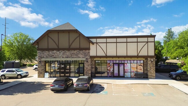
Property Record
20 N Fisher Park Way, Eagle, ID 83616


Property Detail
20 N Fisher Park Way
R0525790190
LOT 5 BLK 2 ARTS WEST SUB
Commercialbuilding
Ada
MU-DA
Idaho
B and X Area of moderate flood hazard, usually the area between the limits of the 100-year and 500-year floods.
5
2024
0.57 AC
2025
Eagle
010232
Boise City/Nampa
3,900 SF
Boise City, ID
NEARBY LISTINGS FOR SALE OR LEASE
DEMOGRAPHICS near 20 N Fisher Park Way
1 mile
3 mile
5 mile
2025 Total Population
3,452
38,938
127,996
2030 Population
3,672
41,407
135,296
Pop Growth 2025-2030
+ 6.37%
+ 6.34%
+ 5.70%
Average Age
43
44
41
2025 Total Households
1,123
13,796
44,980
HH Growth 2025-2030
+ 6.86%
+ 6.84%
+ 6.16%
Median Household Inc
$116,095
$120,746
$110,231
Avg Household Size
3.00
2.80
2.80
2025 Avg HH Vehicles
3.00
2.00
2.00
Median Home Value
$867,346
$799,022
$665,771
Median Year Built
2008
2009
2006
Nearby Places
Map Layers
Map Styles
 Street
 Aerial
Transit
 Traffic
 Biking
Places
Listings with unknown addresses are not visible on the map
- Restaurants
- Banks
- Shops
- Fitness
- Groceries
SALE & LEASE HISTORY
LISTING DATE
SALE/LEASE

Sep 08, 2020
For Lease
May 07, 2021
For Lease
Jun 13, 2024
For Lease
Feb 18, 2022
For Lease
Aug 11, 2025
For Sale
Nearby Properties
Address
Land Use
TOTAL SIZE
Lot Size
Zoning
Address
Land Use
TOTAL SIZE
Lot Size
Zoning
342,567 SF
19.16 AC
MU-DA
Address
Land Use
TOTAL SIZE
Lot Size
Zoning
178,710 SF
13.47 AC
R-13
Address
Land Use
TOTAL SIZE
Lot Size
Zoning
265.60 AC
R-2-DA
Address
Land Use
TOTAL SIZE
Lot Size
Zoning
98,738 SF
4.25 AC
CBD
Address
Land Use
TOTAL SIZE
Lot Size
Zoning
152,123 SF
6 AC
MU-DA
Address
Land Use
TOTAL SIZE
Lot Size
Zoning
170,333 SF
14.65 AC
C-3-DA
Address
Land Use
TOTAL SIZE
Lot Size
Zoning
69,546 SF
4.26 AC
MU-DA
Address
Land Use
TOTAL SIZE
Lot Size
Zoning
65,034 SF
4.44 AC
MU-DA
Address
Land Use
TOTAL SIZE
Lot Size
Zoning
98,612 SF
5.38 AC
MU-DA
Address
Land Use
TOTAL SIZE
Lot Size
Zoning
36,454 SF
3.18 AC
MU
Address
Land Use
TOTAL SIZE
Lot Size
Zoning
81,591 SF
2.88 AC
MU-DA
Address
Land Use
TOTAL SIZE
Lot Size
Zoning
59,778 SF
3.68 AC
C-3-DA
Address
Land Use
TOTAL SIZE
Lot Size
Zoning
68,707 SF
2.83 AC
C-3-DA
Address
Land Use
TOTAL SIZE
Lot Size
Zoning
74,296 SF
4.86 AC
CBD
Address
Land Use
TOTAL SIZE
Lot Size
Zoning
2,496 SF
222.96 AC
R-2-DA
Address
Land Use
TOTAL SIZE
Lot Size
Zoning
80,913 SF
8 AC
C-C
Address
Land Use
TOTAL SIZE
Lot Size
Zoning
34,602 SF
2.61 AC
MU-DA
Address
Land Use
TOTAL SIZE
Lot Size
Zoning
20,595 SF
2.32 AC
MU
Address
Land Use
TOTAL SIZE
Lot Size
Zoning
93,791 SF
6.41 AC
MU-DA
Address
Land Use
TOTAL SIZE
Lot Size
Zoning
56,382 SF
3.94 AC
C-C
Address
Land Use
TOTAL SIZE
Lot Size
Zoning
58,267 SF
3.65 AC
MU-DA
Address
Land Use
TOTAL SIZE
Lot Size
Zoning
104,234 SF
8 AC
MU-DA
Address
Land Use
TOTAL SIZE
Lot Size
Zoning
49,508 SF
1.34 AC
MU-DA
Address
Land Use
TOTAL SIZE
Lot Size
Zoning
89.84 AC
R-4-DA
Address
Land Use
TOTAL SIZE
Lot Size
Zoning
3,840 SF
19.22 AC
R-3-DA-P
Address
Land Use
TOTAL SIZE
Lot Size
Zoning
6,237 SF
1.83 AC
C-C
Address
Land Use
TOTAL SIZE
Lot Size
Zoning
33,881 SF
3.68 AC
MU-DA
Address
Land Use
TOTAL SIZE
Lot Size
Zoning
48,943 SF
4.41 AC
MU
Address
Land Use
TOTAL SIZE
Lot Size
Zoning
40,340 SF
2.63 AC
R-15
Address
Land Use
TOTAL SIZE
Lot Size
Zoning
54,604 SF
2.72 AC
MU-DA
The World's #1 Commercial Real Estate Marketplace
Connect with us
© 2026 CoStar Group
The information above has been obtained from sources believed reliable. While we do not doubt its accuracy we have not verified it and make no guarantee, warranty or representation about it. It is your responsibility to independently confirm its accuracy and completeness. Any projections, opinions, assumptions, or estimates used are for example only and do not represent the current or future performance of the property. The value of this transaction to you depends on tax and other factors which should be evaluated by your tax, financial, and legal advisors. You and your advisors should conduct a careful, independent investigation of the property to determine to your satisfaction the suitability of the property for your needs.