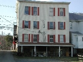
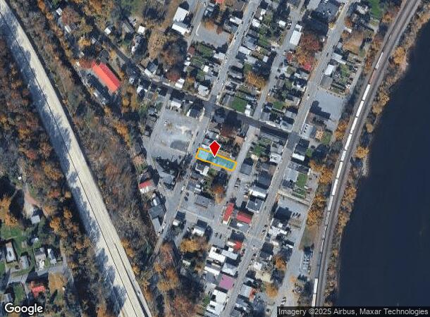
Property Record
20 N High St, Duncannon, PA 17020
NEARBY LISTINGS FOR SALE OR LEASE
-
-
View all Duncannon listings for sale on LoopNet.com
Property Detail
20 N High St
060-118.03-018.000
Perry
Apartment
Pennsylvania
X
0.13 AC
42099C0244E
Perry County
2025
Philadelphia
2025
Harrisburg-Carlisle, PA
030301
DEMOGRAPHICS near 20 N High St
1 Mile
3 Mile
5 Mile
2024 Total Population
2,421
5,438
11,409
2029 Population
2,446
5,483
11,524
Pop Growth 2024-2029
+ 1.03%
+ 0.83%
+ 1.01%
Average Age
41
43
44
2024 Total Households
1,032
2,217
4,592
HH Growth 2024-2029
+ 0.97%
+ 0.86%
+ 1.02%
Median Household Inc
$61,758
$73,246
$80,290
Avg Household Size
2.30
2.40
2.40
2024 Avg HH Vehicles
2.00
2.00
2.00
Median Home Value
$142,381
$179,970
$201,458
Median Year Built
1948
1969
1974
Nearby Places
Map Layers
Map Styles
 Street
 Aerial
- Restaurants
- Banks
- Shops
- Fitness
- Groceries
PUBLIC TRANSPORTATION
AIRPORT
Harrisburg International
DRIVE
WALK
Distance
Harrisburg International
41 min
27.0 mi
Freight Ports
Port of Baltimore
DRIVE
WALK
Distance
Port of Baltimore
136 min
97.3 mi
Nearby Properties
Address
Land Use
TOTAL SIZE
Lot Size
Zoning
Address
Land Use
TOTAL SIZE
Lot Size
Zoning
170.01 AC
RUR
Address
Land Use
TOTAL SIZE
Lot Size
Zoning
43.48 AC
RUR
Address
Land Use
TOTAL SIZE
Lot Size
Zoning
3,721.20 AC
RUR
Address
Land Use
TOTAL SIZE
Lot Size
Zoning
16 AC
RUR
Address
Land Use
TOTAL SIZE
Lot Size
Zoning
15.08 AC
RUR
Address
Land Use
TOTAL SIZE
Lot Size
Zoning
10.62 AC
RUR
Address
Land Use
TOTAL SIZE
Lot Size
Zoning
11.17 AC
RUR
Address
Land Use
TOTAL SIZE
Lot Size
Zoning
2.51 AC
RUR
Address
Land Use
TOTAL SIZE
Lot Size
Zoning
101 AC
Address
Land Use
TOTAL SIZE
Lot Size
Zoning
10,342 SF
11.19 AC
Address
Land Use
TOTAL SIZE
Lot Size
Zoning
85.07 AC
Address
Land Use
TOTAL SIZE
Lot Size
Zoning
1,680.70 AC
RUR
Address
Land Use
TOTAL SIZE
Lot Size
Zoning
5.29 AC
RUR
Address
Land Use
TOTAL SIZE
Lot Size
Zoning
15.02 AC
RUR
Address
Land Use
TOTAL SIZE
Lot Size
Zoning
2.23 AC
MIX
Address
Land Use
TOTAL SIZE
Lot Size
Zoning
8,760 SF
5.40 AC
Address
Land Use
TOTAL SIZE
Lot Size
Zoning
12.46 AC
RUR
Address
Land Use
TOTAL SIZE
Lot Size
Zoning
Address
Land Use
TOTAL SIZE
Lot Size
Zoning
0.89 AC
BC
Address
Land Use
TOTAL SIZE
Lot Size
Zoning
34.98 AC
RUR
Address
Land Use
TOTAL SIZE
Lot Size
Zoning
119 AC
Address
Land Use
TOTAL SIZE
Lot Size
Zoning
113.59 AC
Address
Land Use
TOTAL SIZE
Lot Size
Zoning
4,992 SF
2.52 AC
Address
Land Use
TOTAL SIZE
Lot Size
Zoning
110.54 AC
Address
Land Use
TOTAL SIZE
Lot Size
Zoning
2.58 AC
MIX
Address
Land Use
TOTAL SIZE
Lot Size
Zoning
17.99 AC
RUR
Address
Land Use
TOTAL SIZE
Lot Size
Zoning
9.46 AC
MIX
Address
Land Use
TOTAL SIZE
Lot Size
Zoning
Address
Land Use
TOTAL SIZE
Lot Size
Zoning
7.55 AC
RUR
Address
Land Use
TOTAL SIZE
Lot Size
Zoning
35.64 AC
RUR
The World's #1 Commercial Real Estate Marketplace
Connect with us
© 2025 CoStar Group
The information above has been obtained from sources believed reliable. While we do not doubt its accuracy we have not verified it and make no guarantee, warranty or representation about it. It is your responsibility to independently confirm its accuracy and completeness. Any projections, opinions, assumptions, or estimates used are for example only and do not represent the current or future performance of the property. The value of this transaction to you depends on tax and other factors which should be evaluated by your tax, financial, and legal advisors. You and your advisors should conduct a careful, independent investigation of the property to determine to your satisfaction the suitability of the property for your needs.