Property Record
20 N Main St, Saint George, UT 84770


Current Lease Availabilities
NEARBY LISTINGS FOR SALE OR LEASE
Property Detail
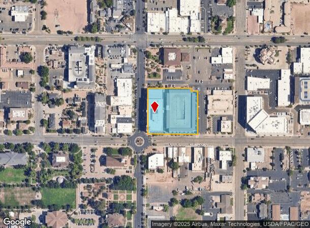
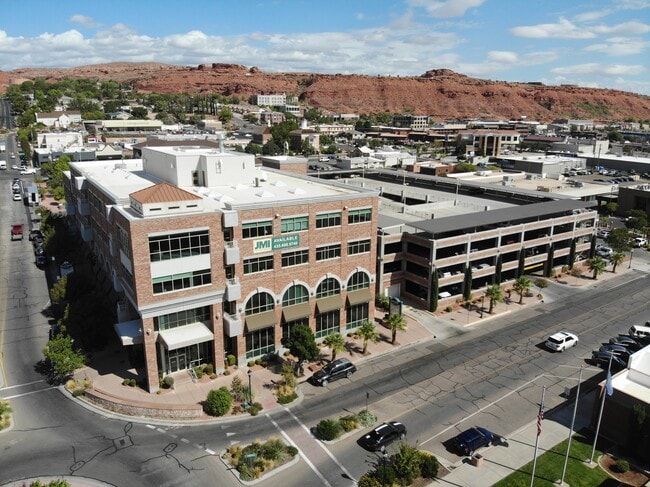
20 N Main St
St. George, UT
St George City Survey
0005739
SUBDIVISION: ST GEORGE CITY SUR PLAT A BLK 26 (SG) LOT: 4 BEG SW COR BLK 26 PLAT A SGCS TH N0*0844 E 281.87 FT ALG W BLK/L; TH S89*5333 E 264 FT TO E LN LOT 4; TH S0*0844 W 16.57 FT TO SE COR LOT 4; TH S89*5341 E 34 FT ALG N LN LOT 1; TH S0*0844 W 26
Commercialnec
Washington
X
Utah
49053C1027G
4
2024
1.96 AC
2025
Downtown Saint George
270301
Other Market Areas
280,428 SF
DEMOGRAPHICS near 20 N Main St
1 Mile
3 Mile
5 Mile
2024 Total Population
9,995
62,576
121,198
2029 Population
12,417
77,474
150,722
Pop Growth 2024-2029
+ 24.23%
+ 23.81%
+ 24.36%
Average Age
36
40
40
2024 Total Households
3,399
22,388
42,028
HH Growth 2024-2029
+ 24.86%
+ 24.52%
+ 25.14%
Median Household Inc
$41,082
$57,092
$65,429
Avg Household Size
2.50
2.60
2.80
2024 Avg HH Vehicles
2.00
2.00
2.00
Median Home Value
$299,536
$373,740
$432,668
Median Year Built
1981
1995
1999
Nearby Places
Map Layers
Map Styles
 Street
 Aerial
- Restaurants
- Banks
- Shops
- Fitness
- Groceries
PUBLIC TRANSPORTATION
AIRPORT
St George Regional
DRIVE
WALK
Distance
St George Regional
6 min
2.1 mi
Nearby Properties
Address
Land Use
TOTAL SIZE
Lot Size
Zoning
Address
Land Use
TOTAL SIZE
Lot Size
Zoning
1,120,988 SF
52.22 AC
PDCOM
Address
Land Use
TOTAL SIZE
Lot Size
Zoning
319,351 SF
31.39 AC
PD
Address
Land Use
TOTAL SIZE
Lot Size
Zoning
319,351 SF
31.39 AC
Address
Land Use
TOTAL SIZE
Lot Size
Zoning
163,605 SF
13.51 AC
C3
Address
Land Use
TOTAL SIZE
Lot Size
Zoning
252,737 SF
3.95 AC
C-4
Address
Land Use
TOTAL SIZE
Lot Size
Zoning
175,817 SF
30.20 AC
Address
Land Use
TOTAL SIZE
Lot Size
Zoning
118,603 SF
16.56 AC
Address
Land Use
TOTAL SIZE
Lot Size
Zoning
141,151 SF
15 AC
PDCOM
Address
Land Use
TOTAL SIZE
Lot Size
Zoning
206,801 SF
12.60 AC
PD
Address
Land Use
TOTAL SIZE
Lot Size
Zoning
9,037 SF
188.69 AC
C2
Address
Land Use
TOTAL SIZE
Lot Size
Zoning
97,572 SF
10.51 AC
PD
Address
Land Use
TOTAL SIZE
Lot Size
Zoning
141,567 SF
1.31 AC
C-4
Address
Land Use
TOTAL SIZE
Lot Size
Zoning
91,517 SF
8.96 AC
C2
Address
Land Use
TOTAL SIZE
Lot Size
Zoning
68,899 SF
7.36 AC
C3
Address
Land Use
TOTAL SIZE
Lot Size
Zoning
84,384 SF
6.34 AC
C2
Address
Land Use
TOTAL SIZE
Lot Size
Zoning
88,445 SF
3.28 AC
C2
Address
Land Use
TOTAL SIZE
Lot Size
Zoning
120,219 SF
11.88 AC
Address
Land Use
TOTAL SIZE
Lot Size
Zoning
97,202 SF
2.92 AC
C3
Address
Land Use
TOTAL SIZE
Lot Size
Zoning
76,907 SF
4 AC
PDCOM
Address
Land Use
TOTAL SIZE
Lot Size
Zoning
94,810 SF
3.15 AC
C-3
Address
Land Use
TOTAL SIZE
Lot Size
Zoning
59,500 SF
4.93 AC
R110
Address
Land Use
TOTAL SIZE
Lot Size
Zoning
57,312 SF
3.14 AC
PDCOM
Address
Land Use
TOTAL SIZE
Lot Size
Zoning
115,588 SF
7.61 AC
R3
Address
Land Use
TOTAL SIZE
Lot Size
Zoning
137,662 SF
7.81 AC
PD
Address
Land Use
TOTAL SIZE
Lot Size
Zoning
67,139 SF
1.25 AC
Address
Land Use
TOTAL SIZE
Lot Size
Zoning
158,638 SF
4.67 AC
C-3
Address
Land Use
TOTAL SIZE
Lot Size
Zoning
69,421 SF
5.73 AC
PDCOM
Address
Land Use
TOTAL SIZE
Lot Size
Zoning
82,440 SF
2.88 AC
Address
Land Use
TOTAL SIZE
Lot Size
Zoning
34,097 SF
5.90 AC
The World's #1 Commercial Real Estate Marketplace
Connect with us
© 2026 CoStar Group
The information above has been obtained from sources believed reliable. While we do not doubt its accuracy we have not verified it and make no guarantee, warranty or representation about it. It is your responsibility to independently confirm its accuracy and completeness. Any projections, opinions, assumptions, or estimates used are for example only and do not represent the current or future performance of the property. The value of this transaction to you depends on tax and other factors which should be evaluated by your tax, financial, and legal advisors. You and your advisors should conduct a careful, independent investigation of the property to determine to your satisfaction the suitability of the property for your needs.