Property Record
20 N Main St, Yardley, PA 19067
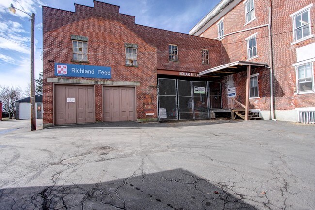

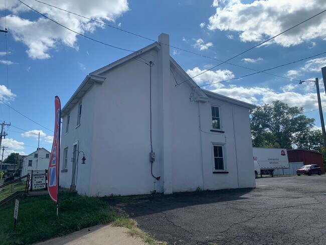
Property Detail
20 N Main St
37-003-034
.8862 AC WS N MAIN ST 513 N OF W UNION ST
Commercialnec
BUCKS
VC
Pennsylvania
B and X Area of moderate flood hazard, usually the area between the limits of the 100-year and 500-year floods.
0.89 AC
2025
Bucks
2026
Philadelphia
105600
Philadelphia-Camden-Wilmington, PA-NJ-DE-MD
31,954 SF
NEARBY LISTINGS FOR SALE OR LEASE
DEMOGRAPHICS near 20 N Main St
1 mile
3 mile
5 mile
2025 Total Population
2,263
16,612
40,713
2030 Population
2,277
16,711
41,164
Pop Growth 2025-2030
+ 0.62%
+ 0.60%
+ 1.11%
Average Age
44
43
43
2025 Total Households
803
6,551
15,562
HH Growth 2025-2030
+ 0.50%
+ 0.44%
+ 1.01%
Median Household Inc
$74,901
$83,333
$95,336
Avg Household Size
2.50
2.40
2.50
2025 Avg HH Vehicles
2.00
2.00
2.00
Median Home Value
$345,251
$324,531
$386,445
Median Year Built
1974
1971
1977
Nearby Places
Map Layers
Map Styles
 Street
 Aerial
Layers
 Traffic
 Biking
Places
Listings with unknown addresses are not visible on the map
- Restaurants
- Banks
- Shops
- Fitness
- Groceries
PUBLIC TRANSPORTATION
AIRPORT
Lehigh Valley International
Drive
Walk
Distance
Lehigh Valley International
33 min
18.0 mi
Trenton Mercer
Drive
Walk
Distance
Trenton Mercer
64 min
37.8 mi
SALE & LEASE HISTORY
LISTING DATE
SALE/LEASE

Oct 17, 2022
For Lease
Jul 13, 2023
For Sale
Jan 30, 2024
For Lease
Feb 24, 2017
For Sale
Nearby Properties
Address
Land Use
TOTAL SIZE
Lot Size
Zoning
Address
Land Use
TOTAL SIZE
Lot Size
Zoning
242,141 SF
61.72 AC
PC
Address
Land Use
TOTAL SIZE
Lot Size
Zoning
51,884 SF
40.42 AC
EXT
Address
Land Use
TOTAL SIZE
Lot Size
Zoning
203,923 SF
34.17 AC
HC
Address
Land Use
TOTAL SIZE
Lot Size
Zoning
157,360 SF
17.34 AC
SRC
Address
Land Use
TOTAL SIZE
Lot Size
Zoning
145,197 SF
17.11 AC
PC
Address
Land Use
TOTAL SIZE
Lot Size
Zoning
127,968 SF
15.38 AC
PC
Address
Land Use
TOTAL SIZE
Lot Size
Zoning
86,827 SF
11.84 AC
PC
Address
Land Use
TOTAL SIZE
Lot Size
Zoning
362,576 SF
25.24 AC
PI
Address
Land Use
TOTAL SIZE
Lot Size
Zoning
145,800 SF
11.66 AC
P1
Address
Land Use
TOTAL SIZE
Lot Size
Zoning
67,443 SF
1.97 AC
NC
Address
Land Use
TOTAL SIZE
Lot Size
Zoning
100,984 SF
7.98 AC
PI
Address
Land Use
TOTAL SIZE
Lot Size
Zoning
186,547 SF
18.74 AC
PI
Address
Land Use
TOTAL SIZE
Lot Size
Zoning
1,200 SF
17.50 AC
PI
Address
Land Use
TOTAL SIZE
Lot Size
Zoning
114,400 SF
9.96 AC
P1
Address
Land Use
TOTAL SIZE
Lot Size
Zoning
71,000 SF
5.90 AC
EXT
Address
Land Use
TOTAL SIZE
Lot Size
Zoning
34,206 SF
11.49 AC
PC
Address
Land Use
TOTAL SIZE
Lot Size
Zoning
36,450 SF
3.09 AC
HC
Address
Land Use
TOTAL SIZE
Lot Size
Zoning
12,734 SF
4.68 AC
HC
Address
Land Use
TOTAL SIZE
Lot Size
Zoning
48,457 SF
2.73 AC
PC
Address
Land Use
TOTAL SIZE
Lot Size
Zoning
170,655 SF
25.75 AC
PI
Address
Land Use
TOTAL SIZE
Lot Size
Zoning
22,150 SF
2.54 AC
R2
Address
Land Use
TOTAL SIZE
Lot Size
Zoning
16,114 SF
6.13 AC
PC
Address
Land Use
TOTAL SIZE
Lot Size
Zoning
144,197 SF
5.38 AC
H
Address
Land Use
TOTAL SIZE
Lot Size
Zoning
107,925 SF
17.05 AC
RA
Address
Land Use
TOTAL SIZE
Lot Size
Zoning
43,840 SF
6 AC
PC
Address
Land Use
TOTAL SIZE
Lot Size
Zoning
50,055 SF
7.75 AC
EXT
Address
Land Use
TOTAL SIZE
Lot Size
Zoning
48,810 SF
10.07 AC
PC
Address
Land Use
TOTAL SIZE
Lot Size
Zoning
82,753 SF
7.85 AC
PC
Address
Land Use
TOTAL SIZE
Lot Size
Zoning
171,127 SF
12.27 AC
LI
Address
Land Use
TOTAL SIZE
Lot Size
Zoning
125,116 SF
9.55 AC
PI
The World's #1 Commercial Real Estate Marketplace
Connect with us
© 2026 CoStar Group
The information above has been obtained from sources believed reliable. While we do not doubt its accuracy we have not verified it and make no guarantee, warranty or representation about it. It is your responsibility to independently confirm its accuracy and completeness. Any projections, opinions, assumptions, or estimates used are for example only and do not represent the current or future performance of the property. The value of this transaction to you depends on tax and other factors which should be evaluated by your tax, financial, and legal advisors. You and your advisors should conduct a careful, independent investigation of the property to determine to your satisfaction the suitability of the property for your needs.