Property Record
20 Pendleton Dr, Hebron, CT 06248
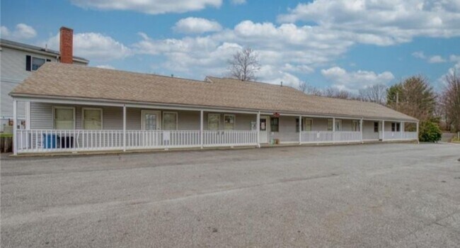

Property Detail
20 Pendleton Dr
HEBR-000070-000000-000036-000002
Capitol
Officebuilding
Connecticut
MS
36.2
2025
0.46 AC
2025
Tolland County
526101
Hartford
2,788 SF
Hartford-West Hartford-East Hartford, CT
NEARBY LISTINGS FOR SALE OR LEASE
DEMOGRAPHICS near 20 Pendleton Dr
1 mile
3 mile
5 mile
2024 Total Population
1,449
6,944
17,604
2029 Population
1,442
6,919
17,543
Pop Growth 2024-2029
(0.48%)
(0.36%)
(0.35%)
Average Age
43
43
44
2024 Total Households
553
2,630
6,761
HH Growth 2024-2029
(0.54%)
(0.42%)
(0.40%)
Median Household Inc
$123,437
$131,550
$125,733
Avg Household Size
2.60
2.60
2.60
2024 Avg HH Vehicles
2.00
2.00
2.00
Median Home Value
$333,950
$327,089
$325,383
Median Year Built
1985
1983
1981
Nearby Places
Map Layers
Map Styles
 Street
 Aerial
Transit
 Traffic
 Biking
Places
Listings with unknown addresses are not visible on the map
- Restaurants
- Banks
- Shops
- Fitness
- Groceries
PUBLIC TRANSPORTATION
AIRPORT
Bradley International
Drive
Walk
Distance
Bradley International
51 min
35.6 mi
Freight Ports
Port of New Haven
Drive
Walk
Distance
Port of New Haven
70 min
54.6 mi
SALE & LEASE HISTORY
LISTING DATE
SALE/LEASE

Oct 06, 2021
For Lease
Apr 25, 2022
For Lease
Apr 25, 2022
For Sale
Nearby Properties
Address
Land Use
TOTAL SIZE
Lot Size
Zoning
Address
Land Use
TOTAL SIZE
Lot Size
Zoning
51.66 AC
R-1
Address
Land Use
TOTAL SIZE
Lot Size
Zoning
111,673 SF
6.79 AC
VS
Address
Land Use
TOTAL SIZE
Lot Size
Zoning
82,384 SF
7.50 AC
R-1
Address
Land Use
TOTAL SIZE
Lot Size
Zoning
88,808 SF
25.90 AC
R-1
Address
Land Use
TOTAL SIZE
Lot Size
Zoning
13,030 SF
2.34 AC
MS
Address
Land Use
TOTAL SIZE
Lot Size
Zoning
34,102 SF
5.93 AC
MS
Address
Land Use
TOTAL SIZE
Lot Size
Zoning
15.92 AC
R-1
Address
Land Use
TOTAL SIZE
Lot Size
Zoning
5.07 AC
MS
Address
Land Use
TOTAL SIZE
Lot Size
Zoning
11,879 SF
7.93 AC
R-1
Address
Land Use
TOTAL SIZE
Lot Size
Zoning
17.50 AC
R-1
Address
Land Use
TOTAL SIZE
Lot Size
Zoning
8,739 SF
0.70 AC
HG
Address
Land Use
TOTAL SIZE
Lot Size
Zoning
9.67 AC
R-1
Address
Land Use
TOTAL SIZE
Lot Size
Zoning
4.53 AC
R-1
Address
Land Use
TOTAL SIZE
Lot Size
Zoning
9,718 SF
4.07 AC
R-1
Address
Land Use
TOTAL SIZE
Lot Size
Zoning
12,412 SF
109.09 AC
R-1
Address
Land Use
TOTAL SIZE
Lot Size
Zoning
9,153 SF
1.44 AC
MS
Address
Land Use
TOTAL SIZE
Lot Size
Zoning
6,374 SF
12.68 AC
R-1
Address
Land Use
TOTAL SIZE
Lot Size
Zoning
6,494 SF
0.79 AC
MS
Address
Land Use
TOTAL SIZE
Lot Size
Zoning
4.03 AC
R-1
Address
Land Use
TOTAL SIZE
Lot Size
Zoning
3.50 AC
R-1
Address
Land Use
TOTAL SIZE
Lot Size
Zoning
3,224 SF
1.54 AC
MS
Address
Land Use
TOTAL SIZE
Lot Size
Zoning
945 SF
15.67 AC
R-1
Address
Land Use
TOTAL SIZE
Lot Size
Zoning
Address
Land Use
TOTAL SIZE
Lot Size
Zoning
6,192 SF
1.39 AC
MS
Address
Land Use
TOTAL SIZE
Lot Size
Zoning
3.73 AC
R-1
Address
Land Use
TOTAL SIZE
Lot Size
Zoning
14,200 SF
6.54 AC
AV
Address
Land Use
TOTAL SIZE
Lot Size
Zoning
7,756 SF
1.08 AC
MS
Address
Land Use
TOTAL SIZE
Lot Size
Zoning
6,192 SF
1.50 AC
HG
Address
Land Use
TOTAL SIZE
Lot Size
Zoning
88.62 AC
VS
Address
Land Use
TOTAL SIZE
Lot Size
Zoning
29.60 AC
NC
The World's #1 Commercial Real Estate Marketplace
Connect with us
© 2026 CoStar Group
The information above has been obtained from sources believed reliable. While we do not doubt its accuracy we have not verified it and make no guarantee, warranty or representation about it. It is your responsibility to independently confirm its accuracy and completeness. Any projections, opinions, assumptions, or estimates used are for example only and do not represent the current or future performance of the property. The value of this transaction to you depends on tax and other factors which should be evaluated by your tax, financial, and legal advisors. You and your advisors should conduct a careful, independent investigation of the property to determine to your satisfaction the suitability of the property for your needs.