Property Record
20 Pinehurst Dr, Bellport, NY 11713
NEARBY LISTINGS FOR SALE OR LEASE
Property Detail
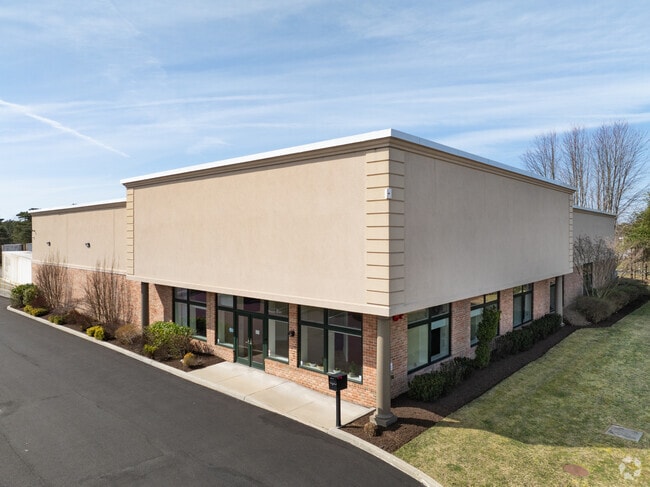
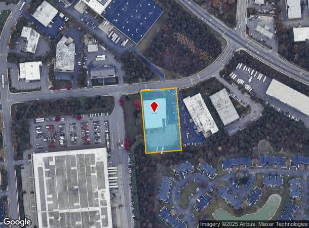
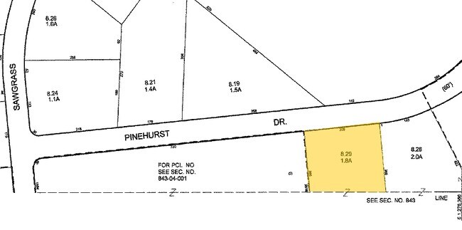
20 Pinehurst Dr
Nassau County-Suffolk County, NY
Brookhaven Industrial Park
0200-813-00-01-00-008-029
BROOKHAVEN INDUSTRIAL PARK 10790 SE
Industrialgeneral
Suffolk
X
New York
36103C0715H
8
2024
1.76 AC
2024
South Central Suffolk
159106
Long Island (New York)
DEMOGRAPHICS near 20 Pinehurst Dr
1 mile
3 mile
5 mile
2024 Total Population
5,239
42,656
130,842
2029 Population
5,156
42,239
129,488
Pop Growth 2024-2029
(1.58%)
(0.98%)
(1.03%)
Average Age
38
40
41
2024 Total Households
1,732
13,680
44,163
HH Growth 2024-2029
(1.73%)
(1.22%)
(1.24%)
Median Household Inc
$93,377
$99,844
$103,033
Avg Household Size
3.00
2.90
2.80
2024 Avg HH Vehicles
2.00
2.00
2.00
Median Home Value
$368,264
$403,173
$398,381
Median Year Built
1984
1976
1975
Nearby Places
Map Layers
Map Styles
 Street
 Aerial
Transit
 Traffic
 Biking
Places
Listings with unknown addresses are not visible on the map
- Restaurants
- Banks
- Shops
- Fitness
- Groceries
PUBLIC TRANSPORTATION
COMMUTER RAIL
Bellport Station (Montauk Branch - Long Island Rail Road)
Drive
Walk
Distance
Bellport Station (Montauk Branch - Long Island Rail Road)
7 min
2.8 mi
Yaphank Station (Greenport Branch - Long Island Rail Road)
Drive
Walk
Distance
Yaphank Station (Greenport Branch - Long Island Rail Road)
7 min
3.6 mi
AIRPORT
Long Island MacArthur
Drive
Walk
Distance
Long Island MacArthur
19 min
10.8 mi
SALE & LEASE HISTORY
LISTING DATE
SALE/LEASE

May 05, 2021
For Sale
Jun 23, 2022
For Sale
Nearby Properties
Address
Land Use
TOTAL SIZE
Lot Size
Zoning
Address
Land Use
TOTAL SIZE
Lot Size
Zoning
4,104 SF
0.58 AC
R15
Address
Land Use
TOTAL SIZE
Lot Size
Zoning
2,196 SF
0.33 AC
VILLA
Address
Land Use
TOTAL SIZE
Lot Size
Zoning
19.30 AC
Address
Land Use
TOTAL SIZE
Lot Size
Zoning
4,925 SF
0.27 AC
VILLA
Address
Land Use
TOTAL SIZE
Lot Size
Zoning
4,000 SF
0.30 AC
VILLA
Address
Land Use
TOTAL SIZE
Lot Size
Zoning
3,238 SF
0.15 AC
VILLA
Address
Land Use
TOTAL SIZE
Lot Size
Zoning
4,225 SF
1.02 AC
R40
Address
Land Use
TOTAL SIZE
Lot Size
Zoning
2,554 SF
0.50 AC
VILLA
Address
Land Use
TOTAL SIZE
Lot Size
Zoning
3,505 SF
1.02 AC
VILLA
Address
Land Use
TOTAL SIZE
Lot Size
Zoning
3,805 SF
0.42 AC
R15
Address
Land Use
TOTAL SIZE
Lot Size
Zoning
4,327 SF
1.05 AC
CR80
Address
Land Use
TOTAL SIZE
Lot Size
Zoning
3,960 SF
0.72 AC
R40
Address
Land Use
TOTAL SIZE
Lot Size
Zoning
3,037 SF
1 AC
CR80
Address
Land Use
TOTAL SIZE
Lot Size
Zoning
3,720 SF
1.01 AC
VILLA
Address
Land Use
TOTAL SIZE
Lot Size
Zoning
3,524 SF
1 AC
VILLA
Address
Land Use
TOTAL SIZE
Lot Size
Zoning
2,324 SF
1.04 AC
VILLA
Address
Land Use
TOTAL SIZE
Lot Size
Zoning
1,696 SF
1.20 AC
R60
Address
Land Use
TOTAL SIZE
Lot Size
Zoning
2,816 SF
0.89 AC
CR80
Address
Land Use
TOTAL SIZE
Lot Size
Zoning
2,605 SF
0.79 AC
CR80
Address
Land Use
TOTAL SIZE
Lot Size
Zoning
2,953 SF
1.01 AC
VILLA
Address
Land Use
TOTAL SIZE
Lot Size
Zoning
2,982 SF
1.02 AC
CR80
Address
Land Use
TOTAL SIZE
Lot Size
Zoning
1,400 SF
0.35 AC
VILLA
Address
Land Use
TOTAL SIZE
Lot Size
Zoning
3,033 SF
0.92 AC
A
Address
Land Use
TOTAL SIZE
Lot Size
Zoning
2,816 SF
1.75 AC
R60
Address
Land Use
TOTAL SIZE
Lot Size
Zoning
840 SF
0.21 AC
R15
Address
Land Use
TOTAL SIZE
Lot Size
Zoning
1,862 SF
0.82 AC
R20
Address
Land Use
TOTAL SIZE
Lot Size
Zoning
2,240 SF
0.93 AC
R20
Address
Land Use
TOTAL SIZE
Lot Size
Zoning
32.04 AC
Address
Land Use
TOTAL SIZE
Lot Size
Zoning
2,298 SF
0.33 AC
R20
Address
Land Use
TOTAL SIZE
Lot Size
Zoning
1,043 SF
1 AC
R40
The World's #1 Commercial Real Estate Marketplace
Connect with us
© 2026 CoStar Group
The information above has been obtained from sources believed reliable. While we do not doubt its accuracy we have not verified it and make no guarantee, warranty or representation about it. It is your responsibility to independently confirm its accuracy and completeness. Any projections, opinions, assumptions, or estimates used are for example only and do not represent the current or future performance of the property. The value of this transaction to you depends on tax and other factors which should be evaluated by your tax, financial, and legal advisors. You and your advisors should conduct a careful, independent investigation of the property to determine to your satisfaction the suitability of the property for your needs.