Property Record
20 Pitcherville Rd, Hubbardston, MA 01452
NEARBY LISTINGS FOR SALE OR LEASE
Property Detail
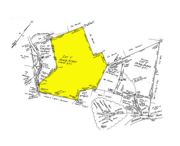
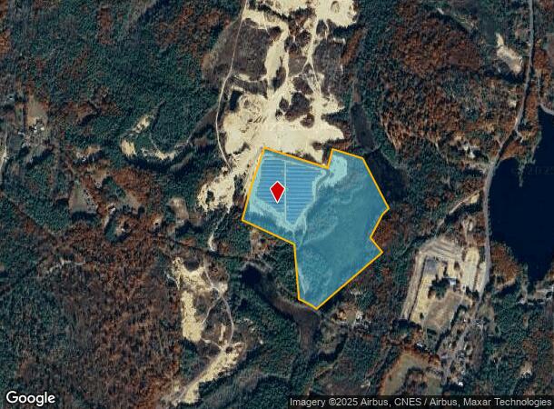
20 Pitcherville Rd
HUBB-000003-000000-000060
Worcester
Privateutilityelectricwatergasnuclearsolarwindetc
Massachusetts
A
60
25027C0220F
50.66 AC
2025
Outlying Worcester
2025
Boston
706100
Worcester, MA-CT
DEMOGRAPHICS near 20 Pitcherville Rd
1 Mile
3 Mile
5 Mile
2024 Total Population
402
9,092
31,373
2029 Population
401
9,065
31,319
Pop Growth 2024-2029
(0.25%)
(0.30%)
(0.17%)
Average Age
44
42
42
2024 Total Households
155
3,663
12,618
HH Growth 2024-2029
0.00%
(0.35%)
(0.16%)
Median Household Inc
$114,843
$72,014
$69,699
Avg Household Size
2.60
2.40
2.40
2024 Avg HH Vehicles
2.00
2.00
2.00
Median Home Value
$341,964
$281,107
$276,005
Median Year Built
1986
1970
1964
Nearby Places
Map Layers
Map Styles
 Street
 Aerial
- Restaurants
- Banks
- Shops
- Fitness
- Groceries
PUBLIC TRANSPORTATION
AIRPORT
Worcester Regional
DRIVE
WALK
Distance
Worcester Regional
46 min
21.8 mi
Freight Ports
Port of Boston
DRIVE
WALK
Distance
Port of Boston
95 min
61.4 mi
Nearby Properties
Address
Land Use
TOTAL SIZE
Lot Size
Zoning
Address
Land Use
TOTAL SIZE
Lot Size
Zoning
15.68 AC
Address
Land Use
TOTAL SIZE
Lot Size
Zoning
7,644 SF
18.38 AC
Address
Land Use
TOTAL SIZE
Lot Size
Zoning
136,517 SF
11.01 AC
Address
Land Use
TOTAL SIZE
Lot Size
Zoning
6,876 SF
305.50 AC
Address
Land Use
TOTAL SIZE
Lot Size
Zoning
7.14 AC
Address
Land Use
TOTAL SIZE
Lot Size
Zoning
0.95 AC
Address
Land Use
TOTAL SIZE
Lot Size
Zoning
124,230 SF
12 AC
Address
Land Use
TOTAL SIZE
Lot Size
Zoning
72,352 SF
6.62 AC
Address
Land Use
TOTAL SIZE
Lot Size
Zoning
8.61 AC
Address
Land Use
TOTAL SIZE
Lot Size
Zoning
79,520 SF
5.86 AC
Address
Land Use
TOTAL SIZE
Lot Size
Zoning
5.12 AC
Address
Land Use
TOTAL SIZE
Lot Size
Zoning
Address
Land Use
TOTAL SIZE
Lot Size
Zoning
17,936 SF
2.47 AC
Address
Land Use
TOTAL SIZE
Lot Size
Zoning
25,312 SF
3.37 AC
Address
Land Use
TOTAL SIZE
Lot Size
Zoning
27,567 SF
1.95 AC
Address
Land Use
TOTAL SIZE
Lot Size
Zoning
41.70 AC
Address
Land Use
TOTAL SIZE
Lot Size
Zoning
0.97 AC
Address
Land Use
TOTAL SIZE
Lot Size
Zoning
Address
Land Use
TOTAL SIZE
Lot Size
Zoning
Address
Land Use
TOTAL SIZE
Lot Size
Zoning
1.63 AC
Address
Land Use
TOTAL SIZE
Lot Size
Zoning
840 SF
14.49 AC
Address
Land Use
TOTAL SIZE
Lot Size
Zoning
Address
Land Use
TOTAL SIZE
Lot Size
Zoning
34,088 SF
7.50 AC
Address
Land Use
TOTAL SIZE
Lot Size
Zoning
10,853 SF
1.09 AC
Address
Land Use
TOTAL SIZE
Lot Size
Zoning
240.36 AC
Address
Land Use
TOTAL SIZE
Lot Size
Zoning
19,894 SF
9.15 AC
Address
Land Use
TOTAL SIZE
Lot Size
Zoning
22,108 SF
3.90 AC
Address
Land Use
TOTAL SIZE
Lot Size
Zoning
201.30 AC
Address
Land Use
TOTAL SIZE
Lot Size
Zoning
3,749 SF
2.94 AC
Address
Land Use
TOTAL SIZE
Lot Size
Zoning
7,200 SF
1.30 AC
The World's #1 Commercial Real Estate Marketplace
Connect with us
© 2025 CoStar Group
The information above has been obtained from sources believed reliable. While we do not doubt its accuracy we have not verified it and make no guarantee, warranty or representation about it. It is your responsibility to independently confirm its accuracy and completeness. Any projections, opinions, assumptions, or estimates used are for example only and do not represent the current or future performance of the property. The value of this transaction to you depends on tax and other factors which should be evaluated by your tax, financial, and legal advisors. You and your advisors should conduct a careful, independent investigation of the property to determine to your satisfaction the suitability of the property for your needs.