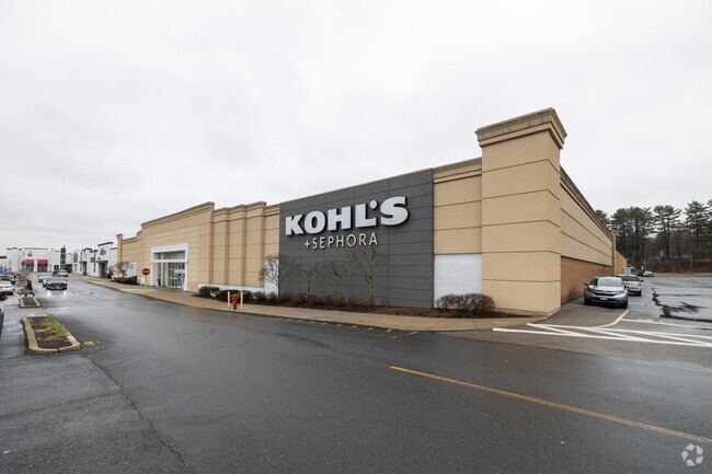
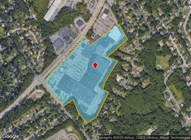
Property Record
20 Route 1, Walpole, MA 02081

NEARBY LISTINGS FOR SALE OR LEASE
Property Detail
20 Route 1
WALP-000029-000015
Norfolk
Commercialnec
Massachusetts
X
30.94 AC
25021C0189F
I-95 Corridor South
2024
Boston
2025
Boston-Cambridge-Newton, MA-NH
411102
DEMOGRAPHICS near 20 Route 1
1 Mile
3 Mile
5 Mile
2024 Total Population
5,084
54,976
120,510
2029 Population
5,050
54,762
119,992
Pop Growth 2024-2029
(0.67%)
(0.39%)
(0.43%)
Average Age
41
42
42
2024 Total Households
1,957
21,591
45,595
HH Growth 2024-2029
(0.72%)
(0.46%)
(0.46%)
Median Household Inc
$144,554
$120,253
$129,908
Avg Household Size
2.60
2.50
2.60
2024 Avg HH Vehicles
2.00
2.00
2.00
Median Home Value
$638,889
$624,675
$653,789
Median Year Built
1972
1965
1968
Nearby Places
Map Layers
Map Styles
 Street
 Aerial
- Restaurants
- Banks
- Shops
- Fitness
- Groceries
PUBLIC TRANSPORTATION
COMMUTER RAIL
Windsor Gardens (Franklin Line - Massachusetts Bay Transportation Authority Commuter Rail (Purple Line))
DRIVE
WALK
Distance
Windsor Gardens (Franklin Line - Massachusetts Bay Transportation Authority Commuter Rail (Purple Line))
6 min
2.3 mi
Sharon (Providence/Stoughton Line - Massachusetts Bay Transportation Authority Commuter Rail (Purple Line))
DRIVE
WALK
Distance
Sharon (Providence/Stoughton Line - Massachusetts Bay Transportation Authority Commuter Rail (Purple Line))
7 min
2.6 mi
AIRPORT
General Edward Lawrence Logan International
DRIVE
WALK
Distance
General Edward Lawrence Logan International
38 min
21.6 mi
Rhode Island Tf Green International
DRIVE
WALK
Distance
Rhode Island Tf Green International
54 min
36.2 mi
Freight Ports
Port of Boston
DRIVE
WALK
Distance
Port of Boston
36 min
19.5 mi
SALE & LEASE HISTORY
LISTING DATE
SALE/LEASE

Sep 25, 2016
For Lease
Jan 28, 2021
For Sale
Aug 23, 2023
For Lease
Nearby Properties
Address
Land Use
TOTAL SIZE
Lot Size
Zoning
Address
Land Use
TOTAL SIZE
Lot Size
Zoning
544,990 SF
63.29 AC
Address
Land Use
TOTAL SIZE
Lot Size
Zoning
380,030 SF
24.87 AC
Address
Land Use
TOTAL SIZE
Lot Size
Zoning
198,498 SF
14 AC
Address
Land Use
TOTAL SIZE
Lot Size
Zoning
5,349 SF
8.74 AC
Address
Land Use
TOTAL SIZE
Lot Size
Zoning
97.60 AC
Address
Land Use
TOTAL SIZE
Lot Size
Zoning
245,693 SF
2.57 AC
Address
Land Use
TOTAL SIZE
Lot Size
Zoning
198,120 SF
51 AC
3
Address
Land Use
TOTAL SIZE
Lot Size
Zoning
28,561 SF
26.30 AC
Address
Land Use
TOTAL SIZE
Lot Size
Zoning
81,009 SF
22.16 AC
Address
Land Use
TOTAL SIZE
Lot Size
Zoning
14.33 AC
Address
Land Use
TOTAL SIZE
Lot Size
Zoning
218,676 SF
22.54 AC
Address
Land Use
TOTAL SIZE
Lot Size
Zoning
263,007 SF
8.11 AC
Address
Land Use
TOTAL SIZE
Lot Size
Zoning
211,362 SF
2.39 AC
Address
Land Use
TOTAL SIZE
Lot Size
Zoning
89,960 SF
52.40 AC
Address
Land Use
TOTAL SIZE
Lot Size
Zoning
11.98 AC
Address
Land Use
TOTAL SIZE
Lot Size
Zoning
127,556 SF
14.88 AC
Address
Land Use
TOTAL SIZE
Lot Size
Zoning
134,165 SF
24.12 AC
Address
Land Use
TOTAL SIZE
Lot Size
Zoning
77,791 SF
2.24 AC
3
Address
Land Use
TOTAL SIZE
Lot Size
Zoning
48,693 SF
9.02 AC
Address
Land Use
TOTAL SIZE
Lot Size
Zoning
52,214 SF
20 AC
Address
Land Use
TOTAL SIZE
Lot Size
Zoning
93,218 SF
9.68 AC
LI
Address
Land Use
TOTAL SIZE
Lot Size
Zoning
113,973 SF
8.70 AC
Address
Land Use
TOTAL SIZE
Lot Size
Zoning
100,012 SF
7.11 AC
Address
Land Use
TOTAL SIZE
Lot Size
Zoning
147,498 SF
9.09 AC
Address
Land Use
TOTAL SIZE
Lot Size
Zoning
64,887 SF
21.10 AC
Address
Land Use
TOTAL SIZE
Lot Size
Zoning
54,948 SF
11.43 AC
Address
Land Use
TOTAL SIZE
Lot Size
Zoning
107,467 SF
19.59 AC
Address
Land Use
TOTAL SIZE
Lot Size
Zoning
158,279 SF
8.60 AC
Address
Land Use
TOTAL SIZE
Lot Size
Zoning
55,182 SF
4.04 AC
The World's #1 Commercial Real Estate Marketplace
Connect with us
© 2025 CoStar Group
The information above has been obtained from sources believed reliable. While we do not doubt its accuracy we have not verified it and make no guarantee, warranty or representation about it. It is your responsibility to independently confirm its accuracy and completeness. Any projections, opinions, assumptions, or estimates used are for example only and do not represent the current or future performance of the property. The value of this transaction to you depends on tax and other factors which should be evaluated by your tax, financial, and legal advisors. You and your advisors should conduct a careful, independent investigation of the property to determine to your satisfaction the suitability of the property for your needs.