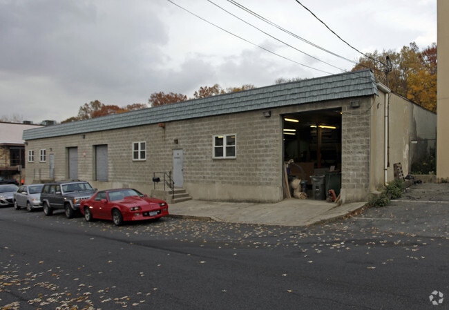
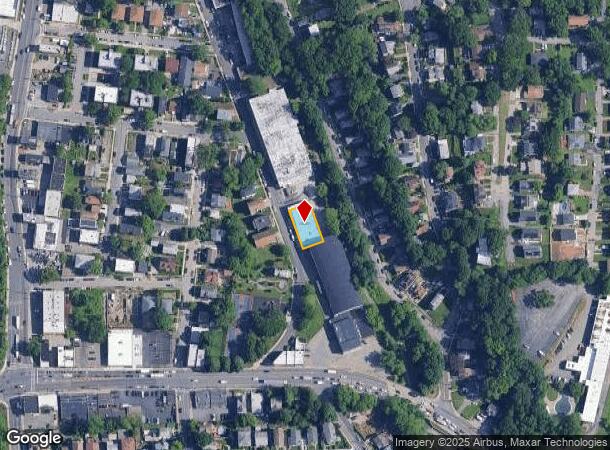
Property Record
20 Runyon Ave, Yonkers, NY 10710

NEARBY LISTINGS FOR SALE OR LEASE
Property Detail
20 Runyon Ave
1800-003-000-03112-000-0040
Westchester
Industrialgeneral
New York
X
40.000
36119C0328F
0.18 AC
2025
Southwest
2024
Westchester/So Connecticut
002000
New York-Jersey City-White Plains, NY-NJ
7,930 SF
DEMOGRAPHICS near 20 Runyon Ave
1 Mile
3 Mile
5 Mile
2024 Total Population
22,565
204,873
488,428
2029 Population
21,520
200,465
470,605
Pop Growth 2024-2029
(4.63%)
(2.15%)
(3.65%)
Average Age
42
41
41
2024 Total Households
7,941
78,440
180,367
HH Growth 2024-2029
(4.85%)
(2.26%)
(3.84%)
Median Household Inc
$94,914
$80,768
$88,291
Avg Household Size
2.70
2.50
2.60
2024 Avg HH Vehicles
2.00
1.00
1.00
Median Home Value
$455,358
$527,422
$612,242
Median Year Built
1953
1956
1952
Nearby Places
Map Layers
Map Styles
 Street
 Aerial
- Restaurants
- Banks
- Shops
- Fitness
- Groceries
PUBLIC TRANSPORTATION
COMMUTER RAIL
Tuckahoe Station (Harlem Line - Metro-North Commuter Railroad Company (Metro-North))
DRIVE
WALK
Distance
Tuckahoe Station (Harlem Line - Metro-North Commuter Railroad Company (Metro-North))
5 min
2.5 mi
Glenwood Station (Hudson Line - Metro-North Commuter Railroad Company (Metro-North))
DRIVE
WALK
Distance
Glenwood Station (Hudson Line - Metro-North Commuter Railroad Company (Metro-North))
9 min
2.5 mi
AIRPORT
LaGuardia
DRIVE
WALK
Distance
LaGuardia
29 min
18.3 mi
Westchester County
DRIVE
WALK
Distance
Westchester County
27 min
19.4 mi
John F Kennedy International
DRIVE
WALK
Distance
John F Kennedy International
40 min
27.0 mi
Freight Ports
NY - Red Hook Container Terminal
DRIVE
WALK
Distance
NY - Red Hook Container Terminal
42 min
26.5 mi
Nearby Properties
Address
Land Use
TOTAL SIZE
Lot Size
Zoning
Address
Land Use
TOTAL SIZE
Lot Size
Zoning
689 SF
423.72 AC
P
Address
Land Use
TOTAL SIZE
Lot Size
Zoning
289.02 AC
P
Address
Land Use
TOTAL SIZE
Lot Size
Zoning
18,000 SF
13.85 AC
A
Address
Land Use
TOTAL SIZE
Lot Size
Zoning
201,590 SF
4.13 AC
BA
Address
Land Use
TOTAL SIZE
Lot Size
Zoning
301,156 SF
13.94 AC
A
Address
Land Use
TOTAL SIZE
Lot Size
Zoning
185.35 AC
P
Address
Land Use
TOTAL SIZE
Lot Size
Zoning
70,737 SF
1.67 AC
BB
Address
Land Use
TOTAL SIZE
Lot Size
Zoning
23.97 AC
Address
Land Use
TOTAL SIZE
Lot Size
Zoning
68,911 SF
16.31 AC
Address
Land Use
TOTAL SIZE
Lot Size
Zoning
64,165 SF
3.24 AC
B
Address
Land Use
TOTAL SIZE
Lot Size
Zoning
Address
Land Use
TOTAL SIZE
Lot Size
Zoning
Address
Land Use
TOTAL SIZE
Lot Size
Zoning
5,170 SF
9.08 AC
B
Address
Land Use
TOTAL SIZE
Lot Size
Zoning
54.65 AC
P
Address
Land Use
TOTAL SIZE
Lot Size
Zoning
28.77 AC
Address
Land Use
TOTAL SIZE
Lot Size
Zoning
13.35 AC
Address
Land Use
TOTAL SIZE
Lot Size
Zoning
11.70 AC
R-30
Address
Land Use
TOTAL SIZE
Lot Size
Zoning
Address
Land Use
TOTAL SIZE
Lot Size
Zoning
7,855 SF
1.10 AC
C
Address
Land Use
TOTAL SIZE
Lot Size
Zoning
69.90 AC
R-20
Address
Land Use
TOTAL SIZE
Lot Size
Zoning
5.37 AC
GI
Address
Land Use
TOTAL SIZE
Lot Size
Zoning
25.58 AC
P
Address
Land Use
TOTAL SIZE
Lot Size
Zoning
5.50 AC
R-20
Address
Land Use
TOTAL SIZE
Lot Size
Zoning
Address
Land Use
TOTAL SIZE
Lot Size
Zoning
25 AC
P
Address
Land Use
TOTAL SIZE
Lot Size
Zoning
122.38 AC
R-30
Address
Land Use
TOTAL SIZE
Lot Size
Zoning
36,413 SF
0.89 AC
A
Address
Land Use
TOTAL SIZE
Lot Size
Zoning
34,560 SF
0.28 AC
BA
Address
Land Use
TOTAL SIZE
Lot Size
Zoning
23,116 SF
1.82 AC
C
Address
Land Use
TOTAL SIZE
Lot Size
Zoning
4.85 AC
GI
The World's #1 Commercial Real Estate Marketplace
Connect with us
© 2025 CoStar Group
The information above has been obtained from sources believed reliable. While we do not doubt its accuracy we have not verified it and make no guarantee, warranty or representation about it. It is your responsibility to independently confirm its accuracy and completeness. Any projections, opinions, assumptions, or estimates used are for example only and do not represent the current or future performance of the property. The value of this transaction to you depends on tax and other factors which should be evaluated by your tax, financial, and legal advisors. You and your advisors should conduct a careful, independent investigation of the property to determine to your satisfaction the suitability of the property for your needs.