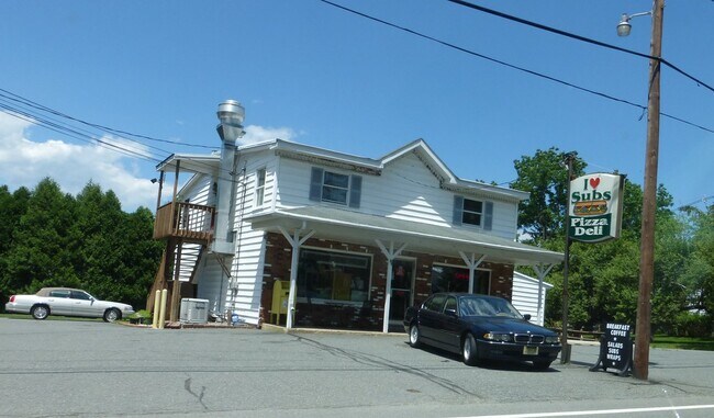
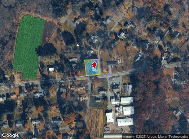
Property Record
20 S Hillside Ave, Flanders, NJ 07836
NEARBY LISTINGS FOR SALE OR LEASE
Property Detail
20 S Hillside Ave
Newark, NJ-PA
Morris
27-05601-0000-00003
New Jersey
Retailwithmorethanonenonretailuse
3
2024
0.45 AC
2025
Western Morris
046110
Northern New Jersey
2,447 SF
DEMOGRAPHICS near 20 S Hillside Ave
1 Mile
3 Mile
5 Mile
2024 Total Population
5,700
28,292
73,648
2029 Population
5,723
28,309
73,606
Pop Growth 2024-2029
+ 0.40%
+ 0.06%
(0.06%)
Average Age
40
42
42
2024 Total Households
2,298
10,232
27,521
HH Growth 2024-2029
0.00%
(0.08%)
(0.13%)
Median Household Inc
$129,852
$140,281
$117,237
Avg Household Size
2.40
2.70
2.60
2024 Avg HH Vehicles
2.00
2.00
2.00
Median Home Value
$466,083
$444,219
$420,016
Median Year Built
1976
1977
1975
Nearby Places
Map Layers
Map Styles
 Street
 Aerial
- Restaurants
- Banks
- Shops
- Fitness
- Groceries
PUBLIC TRANSPORTATION
COMMUTER RAIL
Netcong (Montclair-Boonton Line - NJ Transit Commuter Rail (NJ Transit), Morris & Essex Morristown Line - NJ Transit Commuter Rail (NJ Transit))
DRIVE
WALK
Distance
Netcong (Montclair-Boonton Line - NJ Transit Commuter Rail (NJ Transit), Morris & Essex Morristown Line - NJ Transit Commuter Rail (NJ Transit))
7 min
4.7 mi
Lake Hopatcong (Montclair-Boonton Line - NJ Transit Commuter Rail (NJ Transit), Morris & Essex Morristown Line - NJ Transit Commuter Rail (NJ Transit))
DRIVE
WALK
Distance
Lake Hopatcong (Montclair-Boonton Line - NJ Transit Commuter Rail (NJ Transit), Morris & Essex Morristown Line - NJ Transit Commuter Rail (NJ Transit))
11 min
6.5 mi
AIRPORT
Newark Liberty International
DRIVE
WALK
Distance
Newark Liberty International
47 min
37.3 mi
Freight Ports
Maher Terminal
DRIVE
WALK
Distance
Maher Terminal
50 min
37.7 mi
SALE & LEASE HISTORY
LISTING DATE
SALE/LEASE

Oct 05, 2018
For Sale
Jul 24, 2019
For Sale
Jul 23, 2020
For Sale
Jan 16, 2019
For Sale
Nearby Properties
Address
Land Use
TOTAL SIZE
Lot Size
Zoning
Address
Land Use
TOTAL SIZE
Lot Size
Zoning
174.40 AC
R-5
Address
Land Use
TOTAL SIZE
Lot Size
Zoning
242 AC
G-I
Address
Land Use
TOTAL SIZE
Lot Size
Zoning
25.63 AC
B-3
Address
Land Use
TOTAL SIZE
Lot Size
Zoning
23.74 AC
B-3
Address
Land Use
TOTAL SIZE
Lot Size
Zoning
1,017 SF
1,485.15 AC
P
Address
Land Use
TOTAL SIZE
Lot Size
Zoning
276,378 SF
40.50 AC
OSGU
Address
Land Use
TOTAL SIZE
Lot Size
Zoning
323,779 SF
32.65 AC
L-I
Address
Land Use
TOTAL SIZE
Lot Size
Zoning
350,000 SF
49.35 AC
P
Address
Land Use
TOTAL SIZE
Lot Size
Zoning
8.19 AC
B-3
Address
Land Use
TOTAL SIZE
Lot Size
Zoning
720 SF
1,022.40 AC
R-2
Address
Land Use
TOTAL SIZE
Lot Size
Zoning
6.74 AC
TC
Address
Land Use
TOTAL SIZE
Lot Size
Zoning
136,928 SF
15.72 AC
C-LI
Address
Land Use
TOTAL SIZE
Lot Size
Zoning
154,902 SF
18.96 AC
C-2
Address
Land Use
TOTAL SIZE
Lot Size
Zoning
102,512 SF
17 AC
C-LI
Address
Land Use
TOTAL SIZE
Lot Size
Zoning
142,168 SF
14.84 AC
C-LI
Address
Land Use
TOTAL SIZE
Lot Size
Zoning
4,200 SF
34.12 AC
GU
Address
Land Use
TOTAL SIZE
Lot Size
Zoning
134,760 SF
14 AC
C-LI
Address
Land Use
TOTAL SIZE
Lot Size
Zoning
1.95 AC
PO/R
Address
Land Use
TOTAL SIZE
Lot Size
Zoning
49,548 SF
19.99 AC
P
Address
Land Use
TOTAL SIZE
Lot Size
Zoning
91,518 SF
5 AC
R3SC
Address
Land Use
TOTAL SIZE
Lot Size
Zoning
81,865 SF
20.32 AC
C-2
Address
Land Use
TOTAL SIZE
Lot Size
Zoning
158,800 SF
18.40 AC
G-I
Address
Land Use
TOTAL SIZE
Lot Size
Zoning
36,322 SF
13.31 AC
GU
Address
Land Use
TOTAL SIZE
Lot Size
Zoning
41,310 SF
14.50 AC
GU
Address
Land Use
TOTAL SIZE
Lot Size
Zoning
27,400 SF
16.57 AC
RRAA
Address
Land Use
TOTAL SIZE
Lot Size
Zoning
89.79 AC
OR-5
Address
Land Use
TOTAL SIZE
Lot Size
Zoning
85,802 SF
23.67 AC
P
Address
Land Use
TOTAL SIZE
Lot Size
Zoning
15 AC
OS
Address
Land Use
TOTAL SIZE
Lot Size
Zoning
62,264 SF
29.92 AC
P
Address
Land Use
TOTAL SIZE
Lot Size
Zoning
4.25 AC
AH-3
The World's #1 Commercial Real Estate Marketplace
Connect with us
© 2025 CoStar Group
The information above has been obtained from sources believed reliable. While we do not doubt its accuracy we have not verified it and make no guarantee, warranty or representation about it. It is your responsibility to independently confirm its accuracy and completeness. Any projections, opinions, assumptions, or estimates used are for example only and do not represent the current or future performance of the property. The value of this transaction to you depends on tax and other factors which should be evaluated by your tax, financial, and legal advisors. You and your advisors should conduct a careful, independent investigation of the property to determine to your satisfaction the suitability of the property for your needs.