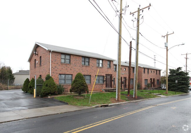
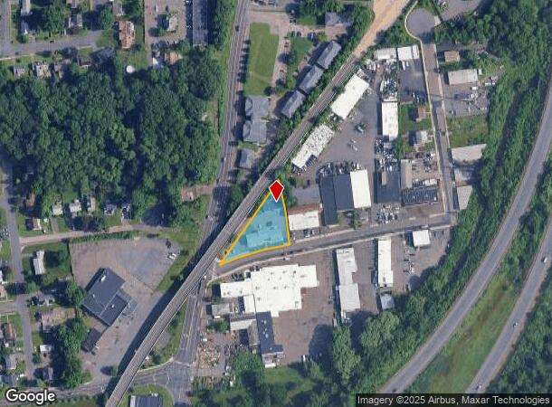
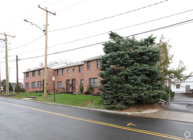
Property Record
20 Saint Claire Ave, New Britain, CT 06051
NEARBY LISTINGS FOR SALE OR LEASE
Property Detail
20 Saint Claire Ave
NBRI-000005C-000000-A000007
Hartford
Commercialofficeresidentialmixeduse
Connecticut
X
0.56 AC
09003C0492F
New Britain/Newington/Wethersfield
2025
Hartford
2025
Hartford-West Hartford-East Hartford, CT
416300
DEMOGRAPHICS near 20 Saint Claire Ave
1 Mile
3 Mile
5 Mile
2024 Total Population
14,102
101,138
188,622
2029 Population
13,989
100,063
186,803
Pop Growth 2024-2029
(0.80%)
(1.06%)
(0.96%)
Average Age
35
39
41
2024 Total Households
4,801
40,035
75,281
HH Growth 2024-2029
(0.73%)
(1.08%)
(0.99%)
Median Household Inc
$51,805
$61,386
$76,830
Avg Household Size
2.40
2.40
2.40
2024 Avg HH Vehicles
2.00
2.00
2.00
Median Home Value
$184,954
$217,068
$256,397
Median Year Built
1954
1957
1959
Nearby Places
Map Layers
Map Styles
 Street
 Aerial
- Restaurants
- Banks
- Shops
- Fitness
- Groceries
PUBLIC TRANSPORTATION
COMMUTER RAIL
Berlin (Hartford Line - CONN DOT)
DRIVE
WALK
Distance
Berlin (Hartford Line - CONN DOT)
9 min
4.6 mi
Berlin Amtrak (Amtrak Hartford Line - Amtrak, Hartford Line - Amtrak, Northeast Regional - Amtrak, Valley Flyer - Amtrak)
DRIVE
WALK
Distance
Berlin Amtrak (Amtrak Hartford Line - Amtrak, Hartford Line - Amtrak, Northeast Regional - Amtrak, Valley Flyer - Amtrak)
9 min
4.6 mi
AIRPORT
Bradley International
DRIVE
WALK
Distance
Bradley International
46 min
26.4 mi
Tweed/New Haven
DRIVE
WALK
Distance
Tweed/New Haven
49 min
35.8 mi
Freight Ports
Port of New Haven
DRIVE
WALK
Distance
Port of New Haven
45 min
33.4 mi
Nearby Properties
Address
Land Use
TOTAL SIZE
Lot Size
Zoning
Address
Land Use
TOTAL SIZE
Lot Size
Zoning
146,740 SF
18.23 AC
TPC
Address
Land Use
TOTAL SIZE
Lot Size
Zoning
284,432 SF
32.12 AC
PL
Address
Land Use
TOTAL SIZE
Lot Size
Zoning
23.64 AC
S3
Address
Land Use
TOTAL SIZE
Lot Size
Zoning
261,072 SF
44.47 AC
PL
Address
Land Use
TOTAL SIZE
Lot Size
Zoning
54.95 AC
PDR
Address
Land Use
TOTAL SIZE
Lot Size
Zoning
20.61 AC
R-10,S
Address
Land Use
TOTAL SIZE
Lot Size
Zoning
131.09 AC
OP
Address
Land Use
TOTAL SIZE
Lot Size
Zoning
19.60 AC
S2
Address
Land Use
TOTAL SIZE
Lot Size
Zoning
155,161 SF
18.18 AC
S1
Address
Land Use
TOTAL SIZE
Lot Size
Zoning
2.07 AC
CBD
Address
Land Use
TOTAL SIZE
Lot Size
Zoning
23.62 AC
A3
Address
Land Use
TOTAL SIZE
Lot Size
Zoning
117,139 SF
6.77 AC
T
Address
Land Use
TOTAL SIZE
Lot Size
Zoning
90,625 SF
0.97 AC
CBD
Address
Land Use
TOTAL SIZE
Lot Size
Zoning
96,238 SF
6.75 AC
T
Address
Land Use
TOTAL SIZE
Lot Size
Zoning
14.68 AC
SIF
Address
Land Use
TOTAL SIZE
Lot Size
Zoning
2.46 AC
CBD
Address
Land Use
TOTAL SIZE
Lot Size
Zoning
33.36 AC
T
Address
Land Use
TOTAL SIZE
Lot Size
Zoning
78,109 SF
8.22 AC
T
Address
Land Use
TOTAL SIZE
Lot Size
Zoning
112,304 SF
10.39 AC
S3
Address
Land Use
TOTAL SIZE
Lot Size
Zoning
16.94 AC
C1
Address
Land Use
TOTAL SIZE
Lot Size
Zoning
171,729 SF
80.59 AC
R-12/
Address
Land Use
TOTAL SIZE
Lot Size
Zoning
14,364 SF
2.72 AC
S3
Address
Land Use
TOTAL SIZE
Lot Size
Zoning
13.13 AC
SDD/BG
Address
Land Use
TOTAL SIZE
Lot Size
Zoning
89,544 SF
6.20 AC
S1
Address
Land Use
TOTAL SIZE
Lot Size
Zoning
21.35 AC
PD
Address
Land Use
TOTAL SIZE
Lot Size
Zoning
111,532 SF
12.50 AC
R-12
Address
Land Use
TOTAL SIZE
Lot Size
Zoning
68 AC
R-20
Address
Land Use
TOTAL SIZE
Lot Size
Zoning
18.40 AC
PD
Address
Land Use
TOTAL SIZE
Lot Size
Zoning
74,670 SF
4.46 AC
S2
Address
Land Use
TOTAL SIZE
Lot Size
Zoning
78,132 SF
11.76 AC
S2
The World's #1 Commercial Real Estate Marketplace
Connect with us
© 2025 CoStar Group
The information above has been obtained from sources believed reliable. While we do not doubt its accuracy we have not verified it and make no guarantee, warranty or representation about it. It is your responsibility to independently confirm its accuracy and completeness. Any projections, opinions, assumptions, or estimates used are for example only and do not represent the current or future performance of the property. The value of this transaction to you depends on tax and other factors which should be evaluated by your tax, financial, and legal advisors. You and your advisors should conduct a careful, independent investigation of the property to determine to your satisfaction the suitability of the property for your needs.