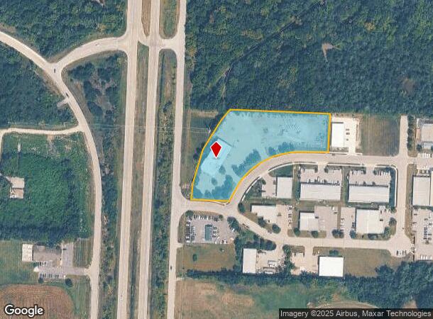
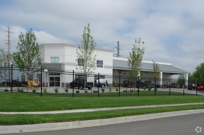
Property Record
20 Se 29Th Ter, Lees Summit, MO 64082

NEARBY LISTINGS FOR SALE OR LEASE
-
-
View all Lees Summit listings for sale on LoopNet.com
Property Detail
20 Se 29Th Ter
Kansas City, MO-KS
Shamrock Park
70-520-01-17-00-0-00-000
SHAMROCK PARK---LOT 9A
Miscellaneous
Jackson
X
Missouri
29095C0551G
9a
2024
3.08 AC
2025
Lee's Summit
013502
Kansas City
8,544 SF
DEMOGRAPHICS near 20 Se 29Th Ter
1 Mile
3 Mile
5 Mile
2024 Total Population
791
31,712
83,967
2029 Population
807
31,882
84,139
Pop Growth 2024-2029
+ 2.02%
+ 0.54%
+ 0.20%
Average Age
39
39
40
2024 Total Households
267
11,296
31,929
HH Growth 2024-2029
+ 1.87%
+ 0.53%
+ 0.20%
Median Household Inc
$138,461
$115,619
$101,510
Avg Household Size
2.90
2.80
2.60
2024 Avg HH Vehicles
2.00
2.00
2.00
Median Home Value
$281,196
$299,984
$279,810
Median Year Built
2002
1998
1991
Nearby Places
Map Layers
Map Styles
 Street
 Aerial
- Restaurants
- Banks
- Shops
- Fitness
- Groceries
PUBLIC TRANSPORTATION
COMMUTER RAIL
DRIVE
WALK
Distance
7 min
3.6 mi
AIRPORT
Kansas City International
DRIVE
WALK
Distance
Kansas City International
60 min
45.3 mi
SALE & LEASE HISTORY
LISTING DATE
SALE/LEASE

Sep 24, 2016
For Sale
Nearby Properties
Address
Land Use
TOTAL SIZE
Lot Size
Zoning
Address
Land Use
TOTAL SIZE
Lot Size
Zoning
107,210 SF
17.13 AC
Address
Land Use
TOTAL SIZE
Lot Size
Zoning
249,821 SF
87.90 AC
Address
Land Use
TOTAL SIZE
Lot Size
Zoning
383,280 SF
0.91 AC
Address
Land Use
TOTAL SIZE
Lot Size
Zoning
563,000 SF
40.34 AC
Address
Land Use
TOTAL SIZE
Lot Size
Zoning
281,235 SF
70.15 AC
Address
Land Use
TOTAL SIZE
Lot Size
Zoning
200,526 SF
Address
Land Use
TOTAL SIZE
Lot Size
Zoning
18,509 SF
20.39 AC
Address
Land Use
TOTAL SIZE
Lot Size
Zoning
143,335 SF
Address
Land Use
TOTAL SIZE
Lot Size
Zoning
155,194 SF
21.03 AC
Address
Land Use
TOTAL SIZE
Lot Size
Zoning
36,744 SF
20.20 AC
Address
Land Use
TOTAL SIZE
Lot Size
Zoning
140,194 SF
29.50 AC
Address
Land Use
TOTAL SIZE
Lot Size
Zoning
65,290 SF
15.70 AC
Address
Land Use
TOTAL SIZE
Lot Size
Zoning
48,764 SF
8.25 AC
Address
Land Use
TOTAL SIZE
Lot Size
Zoning
150,619 SF
19.95 AC
Address
Land Use
TOTAL SIZE
Lot Size
Zoning
74,741 SF
20 AC
Address
Land Use
TOTAL SIZE
Lot Size
Zoning
37,489 SF
9.22 AC
Address
Land Use
TOTAL SIZE
Lot Size
Zoning
118,310 SF
10.55 AC
Address
Land Use
TOTAL SIZE
Lot Size
Zoning
89,962 SF
10.37 AC
Address
Land Use
TOTAL SIZE
Lot Size
Zoning
171,779 SF
11.42 AC
Address
Land Use
TOTAL SIZE
Lot Size
Zoning
30,849 SF
4.99 AC
Address
Land Use
TOTAL SIZE
Lot Size
Zoning
136,620 SF
12.52 AC
Address
Land Use
TOTAL SIZE
Lot Size
Zoning
33,063 SF
17.56 AC
Address
Land Use
TOTAL SIZE
Lot Size
Zoning
Address
Land Use
TOTAL SIZE
Lot Size
Zoning
41,418 SF
19.79 AC
Address
Land Use
TOTAL SIZE
Lot Size
Zoning
59,334 SF
15.12 AC
Address
Land Use
TOTAL SIZE
Lot Size
Zoning
33,020 SF
Address
Land Use
TOTAL SIZE
Lot Size
Zoning
Address
Land Use
TOTAL SIZE
Lot Size
Zoning
4,433 SF
3.44 AC
Address
Land Use
TOTAL SIZE
Lot Size
Zoning
47,298 SF
11.67 AC
Address
Land Use
TOTAL SIZE
Lot Size
Zoning
225,792 SF
9.59 AC
The World's #1 Commercial Real Estate Marketplace
Connect with us
© 2025 CoStar Group
The information above has been obtained from sources believed reliable. While we do not doubt its accuracy we have not verified it and make no guarantee, warranty or representation about it. It is your responsibility to independently confirm its accuracy and completeness. Any projections, opinions, assumptions, or estimates used are for example only and do not represent the current or future performance of the property. The value of this transaction to you depends on tax and other factors which should be evaluated by your tax, financial, and legal advisors. You and your advisors should conduct a careful, independent investigation of the property to determine to your satisfaction the suitability of the property for your needs.