Property Record
20 Spring Rd, Molena, GA 30258
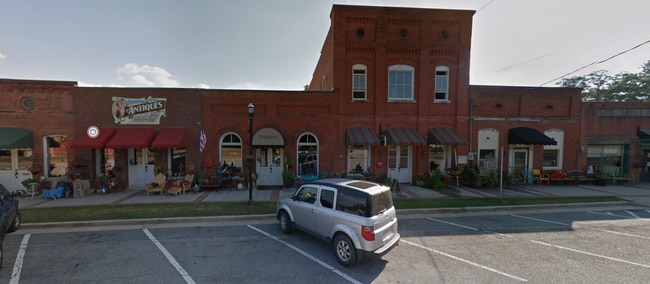

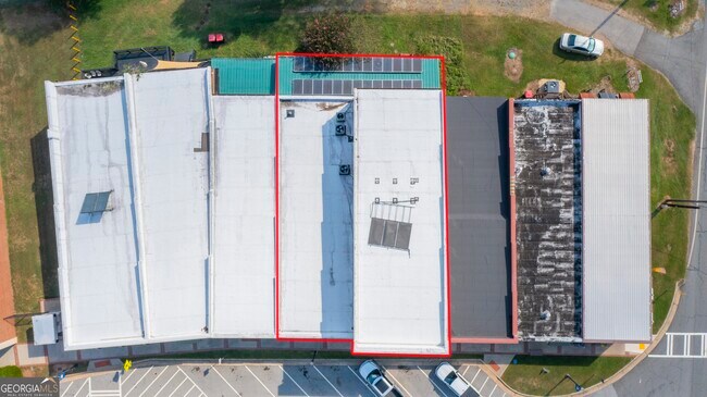

This Property Is For Sale
Property Detail
20 Spring Rd
019A-014
20 SPRING ROAD
Restaurantdrivein
Pike
RESIDENTIA
Georgia
B and X Area of moderate flood hazard, usually the area between the limits of the 100-year and 500-year floods.
0.06 AC
2025
Pike County
2025
Atlanta
010300
Atlanta-Sandy Springs-Roswell, GA
4,320 SF
NEARBY LISTINGS FOR SALE OR LEASE
-
-
View all Molena listings for sale on LoopNet.com
DEMOGRAPHICS near 20 Spring Rd
1 mile
3 mile
5 mile
2024 Total Population
502
1,433
3,423
2029 Population
549
1,544
3,638
Pop Growth 2024-2029
+ 9.36%
+ 7.75%
+ 6.28%
Average Age
40
40
41
2024 Total Households
170
497
1,236
HH Growth 2024-2029
+ 8.82%
+ 7.65%
+ 5.91%
Median Household Inc
$57,272
$61,684
$62,760
Avg Household Size
2.80
2.80
2.70
2024 Avg HH Vehicles
2.00
2.00
2.00
Median Home Value
$192,423
$211,508
$206,154
Median Year Built
1987
1990
1990
Nearby Places
Map Layers
Map Styles
 Street
 Aerial
Transit
 Traffic
 Biking
Places
Listings with unknown addresses are not visible on the map
- Restaurants
- Banks
- Shops
- Fitness
- Groceries
PUBLIC TRANSPORTATION
AIRPORT
Columbus
Drive
Walk
Distance
Columbus
72 min
49.2 mi
Nearby Properties
Address
Land Use
TOTAL SIZE
Lot Size
Zoning
Address
Land Use
TOTAL SIZE
Lot Size
Zoning
567.01 AC
001
Address
Land Use
TOTAL SIZE
Lot Size
Zoning
7,200 SF
410.58 AC
RESIDENTIA
Address
Land Use
TOTAL SIZE
Lot Size
Zoning
482.16 AC
RESIDENTIA
Address
Land Use
TOTAL SIZE
Lot Size
Zoning
19,768 SF
4.88 AC
RESIDENTIA
Address
Land Use
TOTAL SIZE
Lot Size
Zoning
6,149 SF
11.40 AC
RESIDENTIA
Address
Land Use
TOTAL SIZE
Lot Size
Zoning
115.39 AC
AR
Address
Land Use
TOTAL SIZE
Lot Size
Zoning
224.09 AC
001
Address
Land Use
TOTAL SIZE
Lot Size
Zoning
201.24 AC
Address
Land Use
TOTAL SIZE
Lot Size
Zoning
169.01 AC
RESIDENTIA
Address
Land Use
TOTAL SIZE
Lot Size
Zoning
102.84 AC
RESIDENTIA
Address
Land Use
TOTAL SIZE
Lot Size
Zoning
149.33 AC
RESIDENTIA
Address
Land Use
TOTAL SIZE
Lot Size
Zoning
107.70 AC
RESIDENTIA
Address
Land Use
TOTAL SIZE
Lot Size
Zoning
260 AC
RESIDENTIA
Address
Land Use
TOTAL SIZE
Lot Size
Zoning
1,155 SF
123.75 AC
Address
Land Use
TOTAL SIZE
Lot Size
Zoning
8,736 SF
2 AC
C2
Address
Land Use
TOTAL SIZE
Lot Size
Zoning
127.90 AC
Address
Land Use
TOTAL SIZE
Lot Size
Zoning
130.30 AC
RESIDENTIA
Address
Land Use
TOTAL SIZE
Lot Size
Zoning
97 AC
RESIDENTIA
Address
Land Use
TOTAL SIZE
Lot Size
Zoning
110 AC
RESIDENTIA
Address
Land Use
TOTAL SIZE
Lot Size
Zoning
198 AC
RESIDENTIA
Address
Land Use
TOTAL SIZE
Lot Size
Zoning
1,302 SF
128.34 AC
001
Address
Land Use
TOTAL SIZE
Lot Size
Zoning
500 SF
115.98 AC
RESIDENTIA
Address
Land Use
TOTAL SIZE
Lot Size
Zoning
79.39 AC
RESIDENTIA
Address
Land Use
TOTAL SIZE
Lot Size
Zoning
4,315 SF
0.70 AC
RESIDENTIA
Address
Land Use
TOTAL SIZE
Lot Size
Zoning
82.17 AC
RESIDENTIA
Address
Land Use
TOTAL SIZE
Lot Size
Zoning
126.76 AC
RESIDENTIA
Address
Land Use
TOTAL SIZE
Lot Size
Zoning
5,160 SF
2 AC
RESIDENTIA
Address
Land Use
TOTAL SIZE
Lot Size
Zoning
88.81 AC
Address
Land Use
TOTAL SIZE
Lot Size
Zoning
110.72 AC
Address
Land Use
TOTAL SIZE
Lot Size
Zoning
145.52 AC
RESIDENTIA
The World's #1 Commercial Real Estate Marketplace
Connect with us
© 2026 CoStar Group
The information above has been obtained from sources believed reliable. While we do not doubt its accuracy we have not verified it and make no guarantee, warranty or representation about it. It is your responsibility to independently confirm its accuracy and completeness. Any projections, opinions, assumptions, or estimates used are for example only and do not represent the current or future performance of the property. The value of this transaction to you depends on tax and other factors which should be evaluated by your tax, financial, and legal advisors. You and your advisors should conduct a careful, independent investigation of the property to determine to your satisfaction the suitability of the property for your needs.