Property Record
20 State St, Lynn, MA 01901
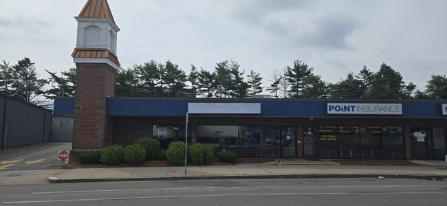
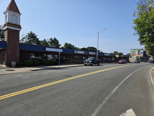
Property Detail
20 State St
LYNN-000068-000731-000002
Essex
Storebuilding
Massachusetts
CBD
2
B and X Area of moderate flood hazard, usually the area between the limits of the 100-year and 500-year floods.
0.57 AC
2025
Saugus/Lynn
2025
Boston
207000
Boston-Cambridge-Newton, MA-NH
10,368 SF
NEARBY LISTINGS FOR SALE OR LEASE
DEMOGRAPHICS near 20 State St
1 mile
3 mile
5 mile
2024 Total Population
46,450
130,293
282,489
2029 Population
46,934
132,162
287,305
Pop Growth 2024-2029
+ 1.04%
+ 1.43%
+ 1.70%
Average Age
37
40
40
2024 Total Households
16,651
47,343
106,233
HH Growth 2024-2029
+ 1.26%
+ 1.54%
+ 1.84%
Median Household Inc
$50,170
$77,673
$87,309
Avg Household Size
2.60
2.60
2.60
2024 Avg HH Vehicles
1.00
2.00
2.00
Median Home Value
$497,323
$606,600
$644,589
Median Year Built
1948
1949
1955
Nearby Places
Map Layers
Map Styles
 Street
 Aerial
Transit
 Traffic
 Biking
Places
Listings with unknown addresses are not visible on the map
- Restaurants
- Banks
- Shops
- Fitness
- Groceries
PUBLIC TRANSPORTATION
TRANSIT/SUBWAY
Lynn (Newburyport/Rockport Line - Massachusetts Bay Transportation Authority Commuter Rail (Purple Line))
Drive
Walk
Distance
Lynn (Newburyport/Rockport Line - Massachusetts Bay Transportation Authority Commuter Rail (Purple Line))
1 min
4 min
0.2 mi
COMMUTER RAIL
Drive
Walk
Distance
3 min
12 min
0.6 mi
River Works (Newburyport/Rockport Line - Massachusetts Bay Transportation Authority Commuter Rail (Purple Line))
Drive
Walk
Distance
River Works (Newburyport/Rockport Line - Massachusetts Bay Transportation Authority Commuter Rail (Purple Line))
5 min
1.8 mi
AIRPORT
General Edward Lawrence Logan International
Drive
Walk
Distance
General Edward Lawrence Logan International
17 min
9.1 mi
Manchester Boston Regional
Drive
Walk
Distance
Manchester Boston Regional
75 min
49.3 mi
Freight Ports
Port of Boston
Drive
Walk
Distance
Port of Boston
23 min
11.7 mi
SALE & LEASE HISTORY
LISTING DATE
SALE/LEASE

Jul 23, 2024
For Lease
Nearby Properties
Address
Land Use
TOTAL SIZE
Lot Size
Zoning
Address
Land Use
TOTAL SIZE
Lot Size
Zoning
195,446 SF
12.98 AC
R2
Address
Land Use
TOTAL SIZE
Lot Size
Zoning
9.73 AC
R5
Address
Land Use
TOTAL SIZE
Lot Size
Zoning
224,840 SF
2.18 AC
RC1
Address
Land Use
TOTAL SIZE
Lot Size
Zoning
277,750 SF
13.47 AC
LI
Address
Land Use
TOTAL SIZE
Lot Size
Zoning
11,840 SF
0.67 AC
CBD
Address
Land Use
TOTAL SIZE
Lot Size
Zoning
4.51 AC
R5
Address
Land Use
TOTAL SIZE
Lot Size
Zoning
345,298 SF
5.74 AC
WF1
Address
Land Use
TOTAL SIZE
Lot Size
Zoning
154,524 SF
5.90 AC
B3
Address
Land Use
TOTAL SIZE
Lot Size
Zoning
190,000 SF
24.42 AC
N/A
Address
Land Use
TOTAL SIZE
Lot Size
Zoning
8.47 AC
PC
Address
Land Use
TOTAL SIZE
Lot Size
Zoning
303,568 SF
1.11 AC
LI
Address
Land Use
TOTAL SIZE
Lot Size
Zoning
153,855 SF
6.08 AC
A-2
Address
Land Use
TOTAL SIZE
Lot Size
Zoning
8.74 AC
WF1A
Address
Land Use
TOTAL SIZE
Lot Size
Zoning
151.89 AC
PC
Address
Land Use
TOTAL SIZE
Lot Size
Zoning
514,553 SF
57.16 AC
R4
Address
Land Use
TOTAL SIZE
Lot Size
Zoning
24.85 AC
R4
Address
Land Use
TOTAL SIZE
Lot Size
Zoning
123,903 SF
0.88 AC
CBD
Address
Land Use
TOTAL SIZE
Lot Size
Zoning
3.22 AC
R5
Address
Land Use
TOTAL SIZE
Lot Size
Zoning
15,240 SF
11.49 AC
WF3
Address
Land Use
TOTAL SIZE
Lot Size
Zoning
5.40 AC
R5
Address
Land Use
TOTAL SIZE
Lot Size
Zoning
98,516 SF
5.01 AC
R1
Address
Land Use
TOTAL SIZE
Lot Size
Zoning
25.02 AC
WF1A
Address
Land Use
TOTAL SIZE
Lot Size
Zoning
68,296 SF
6.01 AC
R2
Address
Land Use
TOTAL SIZE
Lot Size
Zoning
84,681 SF
3.53 AC
R5
Address
Land Use
TOTAL SIZE
Lot Size
Zoning
77,392 SF
6.82 AC
B3
Address
Land Use
TOTAL SIZE
Lot Size
Zoning
80,069 SF
3.13 AC
A-2
Address
Land Use
TOTAL SIZE
Lot Size
Zoning
229,416 SF
14.81 AC
N/A
Address
Land Use
TOTAL SIZE
Lot Size
Zoning
76,589 SF
4.57 AC
R4
Address
Land Use
TOTAL SIZE
Lot Size
Zoning
65.50 AC
WF1
The World's #1 Commercial Real Estate Marketplace
Connect with us
© 2026 CoStar Group
The information above has been obtained from sources believed reliable. While we do not doubt its accuracy we have not verified it and make no guarantee, warranty or representation about it. It is your responsibility to independently confirm its accuracy and completeness. Any projections, opinions, assumptions, or estimates used are for example only and do not represent the current or future performance of the property. The value of this transaction to you depends on tax and other factors which should be evaluated by your tax, financial, and legal advisors. You and your advisors should conduct a careful, independent investigation of the property to determine to your satisfaction the suitability of the property for your needs.