Property Record
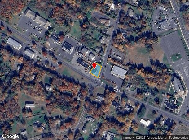
20 Union City Rd, Prospect, CT 06712

NEARBY LISTINGS FOR SALE OR LEASE
Property Detail
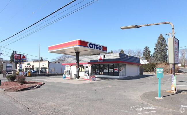
20 Union City Rd
PROS-000110-000156-000020
New Haven
Servicestation
Connecticut
X
20
09009C0138H
0.28 AC
2025
Cheshire
2025
Westchester/So Connecticut
347200
New Haven, CT
1,600 SF
DEMOGRAPHICS near 20 Union City Rd
1 Mile
3 Mile
5 Mile
2024 Total Population
2,517
31,155
138,290
2029 Population
2,505
31,040
137,887
Pop Growth 2024-2029
(0.48%)
(0.37%)
(0.29%)
Average Age
43
41
40
2024 Total Households
935
12,015
54,035
HH Growth 2024-2029
(0.43%)
(0.42%)
(0.31%)
Median Household Inc
$117,035
$90,766
$66,087
Avg Household Size
2.70
2.50
2.50
2024 Avg HH Vehicles
2.00
2.00
2.00
Median Home Value
$316,543
$247,228
$224,150
Median Year Built
1979
1974
1963
Nearby Places
Map Layers
Map Styles
 Street
 Aerial
- Restaurants
- Banks
- Shops
- Fitness
- Groceries
PUBLIC TRANSPORTATION
COMMUTER RAIL
Naugatuck Station (New Haven Line - Metro-North Commuter Railroad Company (Metro-North))
DRIVE
WALK
Distance
Naugatuck Station (New Haven Line - Metro-North Commuter Railroad Company (Metro-North))
9 min
4.7 mi
Waterbury Station (New Haven Line - Metro-North Commuter Railroad Company (Metro-North))
DRIVE
WALK
Distance
Waterbury Station (New Haven Line - Metro-North Commuter Railroad Company (Metro-North))
12 min
5.8 mi
AIRPORT
Tweed/New Haven
DRIVE
WALK
Distance
Tweed/New Haven
37 min
20.3 mi
Bradley International
DRIVE
WALK
Distance
Bradley International
63 min
43.3 mi
Freight Ports
Port of New Haven
DRIVE
WALK
Distance
Port of New Haven
31 min
18.1 mi
Nearby Properties
Address
Land Use
TOTAL SIZE
Lot Size
Zoning
Address
Land Use
TOTAL SIZE
Lot Size
Zoning
77.50 AC
RS
Address
Land Use
TOTAL SIZE
Lot Size
Zoning
88,350 SF
9.50 AC
RS
Address
Land Use
TOTAL SIZE
Lot Size
Zoning
87,221 SF
46.28 AC
RA-1
Address
Land Use
TOTAL SIZE
Lot Size
Zoning
12.49 AC
CA
Address
Land Use
TOTAL SIZE
Lot Size
Zoning
91,324 SF
22.27 AC
RM
Address
Land Use
TOTAL SIZE
Lot Size
Zoning
152,704 SF
17.09 AC
CA
Address
Land Use
TOTAL SIZE
Lot Size
Zoning
95,030 SF
14.30 AC
RA-1
Address
Land Use
TOTAL SIZE
Lot Size
Zoning
115,996 SF
19.57 AC
CA
Address
Land Use
TOTAL SIZE
Lot Size
Zoning
35,200 SF
8.55 AC
B
Address
Land Use
TOTAL SIZE
Lot Size
Zoning
4,368 SF
13.97 AC
RM
Address
Land Use
TOTAL SIZE
Lot Size
Zoning
59,531 SF
2.70 AC
CA
Address
Land Use
TOTAL SIZE
Lot Size
Zoning
6.39 AC
RM
Address
Land Use
TOTAL SIZE
Lot Size
Zoning
90,198 SF
21.32 AC
CA
Address
Land Use
TOTAL SIZE
Lot Size
Zoning
112,055 SF
14.19 AC
RA1
Address
Land Use
TOTAL SIZE
Lot Size
Zoning
62,889 SF
10.97 AC
CA
Address
Land Use
TOTAL SIZE
Lot Size
Zoning
8.02 AC
CA
Address
Land Use
TOTAL SIZE
Lot Size
Zoning
12.71 AC
RM
Address
Land Use
TOTAL SIZE
Lot Size
Zoning
45,193 SF
12.92 AC
B
Address
Land Use
TOTAL SIZE
Lot Size
Zoning
13,114 SF
7.70 AC
Address
Land Use
TOTAL SIZE
Lot Size
Zoning
52,250 SF
14.32 AC
RA1
Address
Land Use
TOTAL SIZE
Lot Size
Zoning
28.89 AC
IP
Address
Land Use
TOTAL SIZE
Lot Size
Zoning
209,186 SF
20.50 AC
IP
Address
Land Use
TOTAL SIZE
Lot Size
Zoning
18.41 AC
CA
Address
Land Use
TOTAL SIZE
Lot Size
Zoning
26,667 SF
5.07 AC
CA
Address
Land Use
TOTAL SIZE
Lot Size
Zoning
7.40 AC
RM
Address
Land Use
TOTAL SIZE
Lot Size
Zoning
3.28 AC
RM
Address
Land Use
TOTAL SIZE
Lot Size
Zoning
8.80 AC
RM
Address
Land Use
TOTAL SIZE
Lot Size
Zoning
4.71 AC
RM
Address
Land Use
TOTAL SIZE
Lot Size
Zoning
106,949 SF
16.50 AC
R15
Address
Land Use
TOTAL SIZE
Lot Size
Zoning
32,394 SF
5 AC
RL
The World's #1 Commercial Real Estate Marketplace
Connect with us
© 2026 CoStar Group
The information above has been obtained from sources believed reliable. While we do not doubt its accuracy we have not verified it and make no guarantee, warranty or representation about it. It is your responsibility to independently confirm its accuracy and completeness. Any projections, opinions, assumptions, or estimates used are for example only and do not represent the current or future performance of the property. The value of this transaction to you depends on tax and other factors which should be evaluated by your tax, financial, and legal advisors. You and your advisors should conduct a careful, independent investigation of the property to determine to your satisfaction the suitability of the property for your needs.