Property Record
20 University Estates Blvd, Athens, OH 45701


NEARBY LISTINGS FOR SALE OR LEASE
-
-
View all Athens listings for sale on LoopNet.com
Property Detail
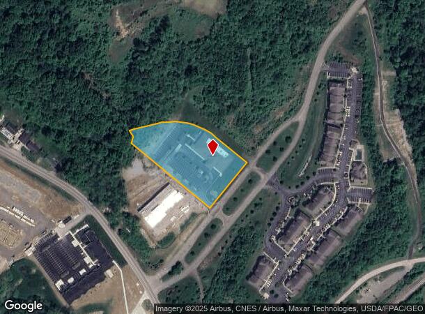
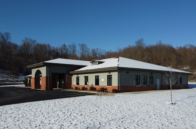
20 University Estates Blvd
Athens, OH
Univ Est
A02-74000076-01
PT LOT 11 UNIV EST 2.335AC
Medicalbuilding
Athens
X
Ohio
39009C0210D
11
2024
2.34 AC
2024
Ohio South Area
972900
Other Market Areas
13,372 SF
DEMOGRAPHICS near 20 University Estates Blvd
1 Mile
3 Mile
5 Mile
2024 Total Population
1,695
25,753
32,730
2029 Population
1,697
25,512
32,439
Pop Growth 2024-2029
+ 0.12%
(0.94%)
(0.89%)
Average Age
37
32
34
2024 Total Households
733
9,595
12,611
HH Growth 2024-2029
0.00%
(0.80%)
(0.85%)
Median Household Inc
$55,319
$40,037
$44,055
Avg Household Size
2.20
2.10
2.20
2024 Avg HH Vehicles
2.00
2.00
2.00
Median Home Value
$177,981
$228,149
$219,446
Median Year Built
1989
1978
1978
Nearby Places
Map Layers
Map Styles
 Street
 Aerial
- Restaurants
- Banks
- Shops
- Fitness
- Groceries
SALE & LEASE HISTORY
LISTING DATE
SALE/LEASE

Jan 16, 2025
For Sale
Jan 07, 2025
For Sale
Nearby Properties
Address
Land Use
TOTAL SIZE
Lot Size
Zoning
Address
Land Use
TOTAL SIZE
Lot Size
Zoning
270,480 SF
100.28 AC
Address
Land Use
TOTAL SIZE
Lot Size
Zoning
0.30 AC
Address
Land Use
TOTAL SIZE
Lot Size
Zoning
380,042 SF
11.62 AC
Address
Land Use
TOTAL SIZE
Lot Size
Zoning
357,956 SF
1.84 AC
Address
Land Use
TOTAL SIZE
Lot Size
Zoning
297,351 SF
33.83 AC
Address
Land Use
TOTAL SIZE
Lot Size
Zoning
128,165 SF
0.17 AC
Address
Land Use
TOTAL SIZE
Lot Size
Zoning
329,244 SF
Address
Land Use
TOTAL SIZE
Lot Size
Zoning
10.06 AC
Address
Land Use
TOTAL SIZE
Lot Size
Zoning
20.35 AC
Address
Land Use
TOTAL SIZE
Lot Size
Zoning
22 AC
Address
Land Use
TOTAL SIZE
Lot Size
Zoning
9.80 AC
Address
Land Use
TOTAL SIZE
Lot Size
Zoning
191,801 SF
3 AC
Address
Land Use
TOTAL SIZE
Lot Size
Zoning
43,469 SF
4.78 AC
Address
Land Use
TOTAL SIZE
Lot Size
Zoning
12 AC
Address
Land Use
TOTAL SIZE
Lot Size
Zoning
150,578 SF
2.59 AC
Address
Land Use
TOTAL SIZE
Lot Size
Zoning
169,832 SF
0.49 AC
Address
Land Use
TOTAL SIZE
Lot Size
Zoning
117,143 SF
0.93 AC
Address
Land Use
TOTAL SIZE
Lot Size
Zoning
114,857 SF
0.48 AC
Address
Land Use
TOTAL SIZE
Lot Size
Zoning
24.23 AC
Address
Land Use
TOTAL SIZE
Lot Size
Zoning
61,456 SF
1.09 AC
Address
Land Use
TOTAL SIZE
Lot Size
Zoning
113,828 SF
0.71 AC
Address
Land Use
TOTAL SIZE
Lot Size
Zoning
116,023 SF
0.85 AC
Address
Land Use
TOTAL SIZE
Lot Size
Zoning
99,964 SF
1.04 AC
Address
Land Use
TOTAL SIZE
Lot Size
Zoning
112,201 SF
8.11 AC
Address
Land Use
TOTAL SIZE
Lot Size
Zoning
58,516 SF
23.99 AC
Address
Land Use
TOTAL SIZE
Lot Size
Zoning
183,602 SF
0.04 AC
Address
Land Use
TOTAL SIZE
Lot Size
Zoning
17,781 SF
101.48 AC
Address
Land Use
TOTAL SIZE
Lot Size
Zoning
7.25 AC
Address
Land Use
TOTAL SIZE
Lot Size
Zoning
127,035 SF
0.55 AC
Address
Land Use
TOTAL SIZE
Lot Size
Zoning
157,903 SF
14.39 AC
The World's #1 Commercial Real Estate Marketplace
Connect with us
© 2026 CoStar Group
The information above has been obtained from sources believed reliable. While we do not doubt its accuracy we have not verified it and make no guarantee, warranty or representation about it. It is your responsibility to independently confirm its accuracy and completeness. Any projections, opinions, assumptions, or estimates used are for example only and do not represent the current or future performance of the property. The value of this transaction to you depends on tax and other factors which should be evaluated by your tax, financial, and legal advisors. You and your advisors should conduct a careful, independent investigation of the property to determine to your satisfaction the suitability of the property for your needs.