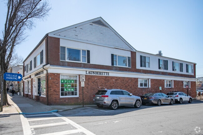
Property Record
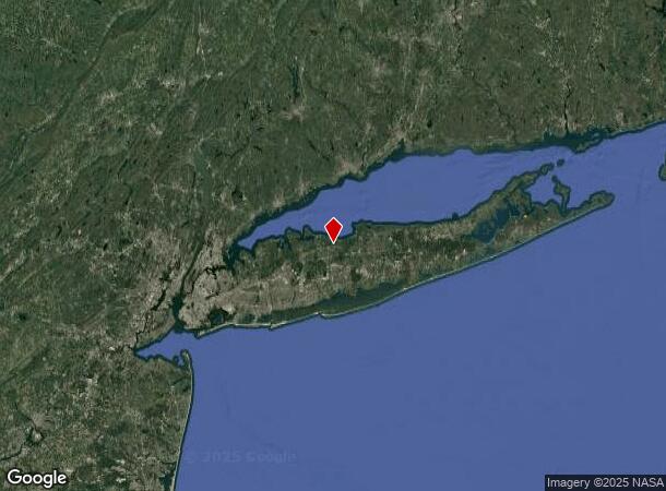
20 W Main St, Kings Park, NY 11754

NEARBY LISTINGS FOR SALE OR LEASE
Property Detail
20 W Main St
0903-002-00-02-00-021-000
87-EQ +1030088 2ND FL AF +675089 FIN N/C
Commercialnec
Suffolk
AE
New York
36103C0193H
21
2024
0.18 AC
2024
Eastern Suffolk
134702
Long Island (New York)
9,000 SF
Nassau County-Suffolk County, NY
DEMOGRAPHICS near 20 W Main St
1 Mile
3 Mile
5 Mile
2024 Total Population
3,396
11,157
22,965
2029 Population
3,527
11,586
23,931
Pop Growth 2024-2029
+ 3.86%
+ 3.85%
+ 4.21%
Average Age
47
46
46
2024 Total Households
1,464
4,615
9,424
HH Growth 2024-2029
+ 3.69%
+ 3.79%
+ 4.10%
Median Household Inc
$110,322
$111,465
$129,365
Avg Household Size
2.30
2.40
2.40
2024 Avg HH Vehicles
2.00
2.00
2.00
Median Home Value
$1,066,644
$987,612
$994,203
Median Year Built
1976
1981
1982
Nearby Places
Map Layers
Map Styles
 Street
 Aerial
- Restaurants
- Banks
- Shops
- Fitness
- Groceries
PUBLIC TRANSPORTATION
COMMUTER RAIL
Kings Park Station (Port Jefferson Branch - Long Island Rail Road)
DRIVE
WALK
Distance
Kings Park Station (Port Jefferson Branch - Long Island Rail Road)
1 min
10 min
0.6 mi
Northport Station (Port Jefferson Branch - Long Island Rail Road)
DRIVE
WALK
Distance
Northport Station (Port Jefferson Branch - Long Island Rail Road)
8 min
4.3 mi
AIRPORT
Long Island MacArthur
DRIVE
WALK
Distance
Long Island MacArthur
24 min
16.0 mi
Freight Ports
Port of New Haven
DRIVE
WALK
Distance
Port of New Haven
133 min
54.1 mi
SALE & LEASE HISTORY
LISTING DATE
SALE/LEASE

Nov 20, 2018
For Lease
Nov 17, 2021
For Sale
Nearby Properties
Address
Land Use
TOTAL SIZE
Lot Size
Zoning
Address
Land Use
TOTAL SIZE
Lot Size
Zoning
853.98 AC
Address
Land Use
TOTAL SIZE
Lot Size
Zoning
3,060 SF
0.10 AC
VILLA
Address
Land Use
TOTAL SIZE
Lot Size
Zoning
26.60 AC
Address
Land Use
TOTAL SIZE
Lot Size
Zoning
5,792 SF
0.36 AC
VILLA
Address
Land Use
TOTAL SIZE
Lot Size
Zoning
300 AC
R80
Address
Land Use
TOTAL SIZE
Lot Size
Zoning
1,648 SF
0.02 AC
VILLA
Address
Land Use
TOTAL SIZE
Lot Size
Zoning
14.50 AC
Address
Land Use
TOTAL SIZE
Lot Size
Zoning
368.36 AC
Address
Land Use
TOTAL SIZE
Lot Size
Zoning
159.25 AC
Address
Land Use
TOTAL SIZE
Lot Size
Zoning
0.23 AC
R10
Address
Land Use
TOTAL SIZE
Lot Size
Zoning
251.38 AC
Address
Land Use
TOTAL SIZE
Lot Size
Zoning
Address
Land Use
TOTAL SIZE
Lot Size
Zoning
Address
Land Use
TOTAL SIZE
Lot Size
Zoning
Address
Land Use
TOTAL SIZE
Lot Size
Zoning
18.82 AC
Address
Land Use
TOTAL SIZE
Lot Size
Zoning
6.41 AC
Address
Land Use
TOTAL SIZE
Lot Size
Zoning
6.75 AC
Address
Land Use
TOTAL SIZE
Lot Size
Zoning
0.01 AC
B1
Address
Land Use
TOTAL SIZE
Lot Size
Zoning
23.95 AC
Address
Land Use
TOTAL SIZE
Lot Size
Zoning
0.52 AC
Address
Land Use
TOTAL SIZE
Lot Size
Zoning
9.97 AC
Address
Land Use
TOTAL SIZE
Lot Size
Zoning
Address
Land Use
TOTAL SIZE
Lot Size
Zoning
12.90 AC
Address
Land Use
TOTAL SIZE
Lot Size
Zoning
25.80 AC
Address
Land Use
TOTAL SIZE
Lot Size
Zoning
69.15 AC
Address
Land Use
TOTAL SIZE
Lot Size
Zoning
2.45 AC
Address
Land Use
TOTAL SIZE
Lot Size
Zoning
15.80 AC
Address
Land Use
TOTAL SIZE
Lot Size
Zoning
158.50 AC
The World's #1 Commercial Real Estate Marketplace
Connect with us
© 2026 CoStar Group
The information above has been obtained from sources believed reliable. While we do not doubt its accuracy we have not verified it and make no guarantee, warranty or representation about it. It is your responsibility to independently confirm its accuracy and completeness. Any projections, opinions, assumptions, or estimates used are for example only and do not represent the current or future performance of the property. The value of this transaction to you depends on tax and other factors which should be evaluated by your tax, financial, and legal advisors. You and your advisors should conduct a careful, independent investigation of the property to determine to your satisfaction the suitability of the property for your needs.