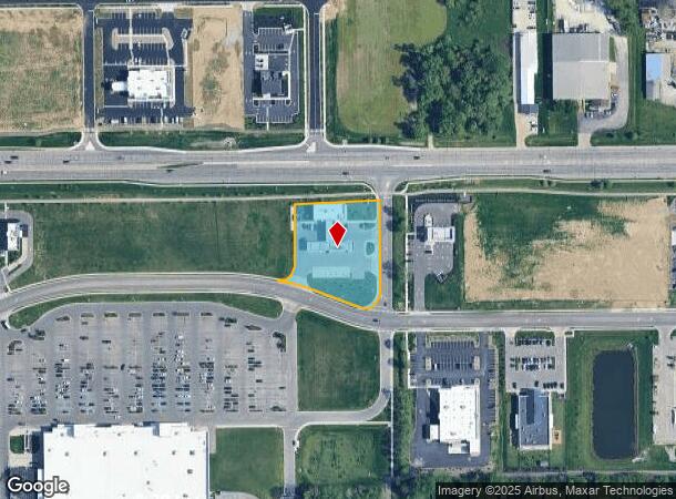
Property Record
20 W Spring Mill Pointe Dr, Westfield, IN 46074
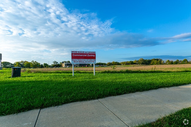

Current Lease Availabilities
NEARBY LISTINGS FOR SALE OR LEASE
Property Detail
20 W Spring Mill Pointe Dr
Indianapolis-Carmel-Anderson, IN
Meijer Westfield Subdivision
29-09-02-000-001.000-015
ACREAGE 1.38, SECTION 2, TOWNSHIP 18, RANGE 3, MEIJER WESTFIELD SUBDIVISION, LOT 2, IRREGULAR SHAPE, ADDITIONAL LEGAL DESCRIPTION: RAILROAD PENN CENTRAL
Servicestationmarket
Hamilton
X
Indiana
18057C0120G
2
2023
1.38 AC
2024
Far North Hamilton Cnty
110406
Indianapolis
3,346 SF
DEMOGRAPHICS near 20 W Spring Mill Pointe Dr
1 Mile
3 Mile
5 Mile
2024 Total Population
7,503
43,256
104,642
2029 Population
8,454
49,517
119,219
Pop Growth 2024-2029
+ 12.67%
+ 14.47%
+ 13.93%
Average Age
36
37
38
2024 Total Households
2,896
15,503
38,691
HH Growth 2024-2029
+ 12.60%
+ 14.44%
+ 13.95%
Median Household Inc
$96,898
$99,978
$104,542
Avg Household Size
2.60
2.70
2.70
2024 Avg HH Vehicles
2.00
2.00
2.00
Median Home Value
$275,285
$347,819
$367,119
Median Year Built
2008
2006
2005
Nearby Places
Map Layers
Map Styles
 Street
 Aerial
- Restaurants
- Banks
- Shops
- Fitness
- Groceries
PUBLIC TRANSPORTATION
AIRPORT
Indianapolis International
DRIVE
WALK
Distance
Indianapolis International
57 min
36.6 mi
Freight Ports
Port of Toledo
DRIVE
WALK
Distance
Port of Toledo
262 min
216.4 mi
Nearby Properties
Address
Land Use
TOTAL SIZE
Lot Size
Zoning
Address
Land Use
TOTAL SIZE
Lot Size
Zoning
27,385 SF
77.27 AC
Address
Land Use
TOTAL SIZE
Lot Size
Zoning
504,699 SF
40 AC
Address
Land Use
TOTAL SIZE
Lot Size
Zoning
383,016 SF
16.62 AC
Address
Land Use
TOTAL SIZE
Lot Size
Zoning
328,692 SF
12 AC
Address
Land Use
TOTAL SIZE
Lot Size
Zoning
388,202 SF
23.97 AC
Address
Land Use
TOTAL SIZE
Lot Size
Zoning
6.46 AC
Address
Land Use
TOTAL SIZE
Lot Size
Zoning
296,315 SF
17.65 AC
Address
Land Use
TOTAL SIZE
Lot Size
Zoning
97,726 SF
8.49 AC
Address
Land Use
TOTAL SIZE
Lot Size
Zoning
370,914 SF
14.30 AC
Address
Land Use
TOTAL SIZE
Lot Size
Zoning
145,444 SF
34.32 AC
Address
Land Use
TOTAL SIZE
Lot Size
Zoning
173,884 SF
14.07 AC
Address
Land Use
TOTAL SIZE
Lot Size
Zoning
203,619 SF
6.66 AC
Address
Land Use
TOTAL SIZE
Lot Size
Zoning
129,851 SF
42.03 AC
Address
Land Use
TOTAL SIZE
Lot Size
Zoning
281,397 SF
18.08 AC
Address
Land Use
TOTAL SIZE
Lot Size
Zoning
153,602 SF
50.17 AC
Address
Land Use
TOTAL SIZE
Lot Size
Zoning
141,255 SF
21.61 AC
Address
Land Use
TOTAL SIZE
Lot Size
Zoning
231,080 SF
9.28 AC
Address
Land Use
TOTAL SIZE
Lot Size
Zoning
73,680 SF
19.08 AC
Address
Land Use
TOTAL SIZE
Lot Size
Zoning
87,040 SF
24.23 AC
Address
Land Use
TOTAL SIZE
Lot Size
Zoning
314,499 SF
12 AC
Address
Land Use
TOTAL SIZE
Lot Size
Zoning
147,081 SF
56.70 AC
Address
Land Use
TOTAL SIZE
Lot Size
Zoning
290,862 SF
2.54 AC
Address
Land Use
TOTAL SIZE
Lot Size
Zoning
282,022 SF
7.65 AC
Address
Land Use
TOTAL SIZE
Lot Size
Zoning
149,213 SF
14.25 AC
Address
Land Use
TOTAL SIZE
Lot Size
Zoning
65,466 SF
7 AC
Address
Land Use
TOTAL SIZE
Lot Size
Zoning
265,084 SF
22.35 AC
Address
Land Use
TOTAL SIZE
Lot Size
Zoning
159,146 SF
12.97 AC
Address
Land Use
TOTAL SIZE
Lot Size
Zoning
77,790 SF
3.77 AC
Address
Land Use
TOTAL SIZE
Lot Size
Zoning
133,160 SF
7.91 AC
Address
Land Use
TOTAL SIZE
Lot Size
Zoning
36,480 SF
2.42 AC
The World's #1 Commercial Real Estate Marketplace
Connect with us
© 2025 CoStar Group
The information above has been obtained from sources believed reliable. While we do not doubt its accuracy we have not verified it and make no guarantee, warranty or representation about it. It is your responsibility to independently confirm its accuracy and completeness. Any projections, opinions, assumptions, or estimates used are for example only and do not represent the current or future performance of the property. The value of this transaction to you depends on tax and other factors which should be evaluated by your tax, financial, and legal advisors. You and your advisors should conduct a careful, independent investigation of the property to determine to your satisfaction the suitability of the property for your needs.