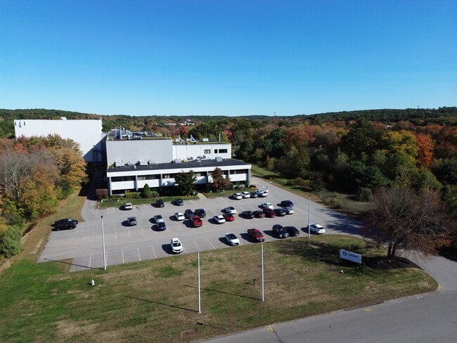
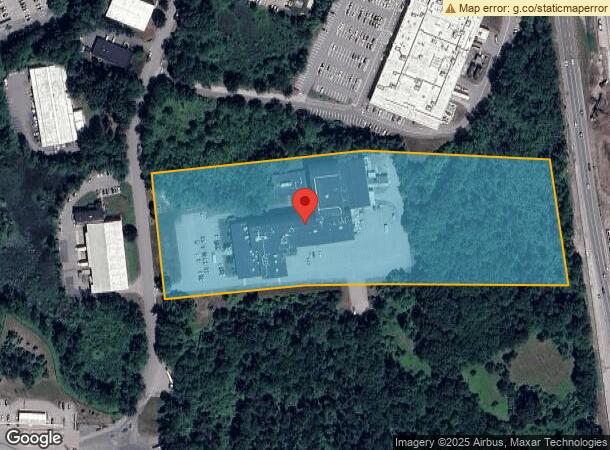
Property Record
20 Walkup Dr, Westborough, MA 01581

NEARBY LISTINGS FOR SALE OR LEASE
Property Detail
20 Walkup Dr
Scientificpharmaceuticalmedicalresearchfacility
Worcester
A
Massachusetts
25027C0664F
10.25 AC
2025
The Boroughs
2025
Boston
761200
Worcester, MA-CT
113,045 SF
WBOR-000023-000015
DEMOGRAPHICS near 20 Walkup Dr
1 Mile
3 Mile
5 Mile
2024 Total Population
226
21,282
70,047
2029 Population
224
21,209
70,002
Pop Growth 2024-2029
(0.88%)
(0.34%)
(0.06%)
Average Age
37
40
40
2024 Total Households
79
7,769
25,720
HH Growth 2024-2029
(1.27%)
(0.36%)
(0.09%)
Median Household Inc
$137,500
$130,809
$141,854
Avg Household Size
2.80
2.70
2.70
2024 Avg HH Vehicles
2.00
2.00
2.00
Median Home Value
$664,285
$634,381
$637,782
Median Year Built
1992
1977
1982
Nearby Places
Map Layers
Map Styles
 Street
 Aerial
- Restaurants
- Banks
- Shops
- Fitness
- Groceries
PUBLIC TRANSPORTATION
COMMUTER RAIL
Southborough (Framingham/Worcester Line - Massachusetts Bay Transportation Authority Commuter Rail (Purple Line))
DRIVE
WALK
Distance
Southborough (Framingham/Worcester Line - Massachusetts Bay Transportation Authority Commuter Rail (Purple Line))
14 min
9.1 mi
AIRPORT
Worcester Regional
DRIVE
WALK
Distance
Worcester Regional
34 min
21.3 mi
General Edward Lawrence Logan International
DRIVE
WALK
Distance
General Edward Lawrence Logan International
44 min
32.7 mi
Freight Ports
Port of Boston
DRIVE
WALK
Distance
Port of Boston
42 min
31.0 mi
Nearby Properties
Address
Land Use
TOTAL SIZE
Lot Size
Zoning
Address
Land Use
TOTAL SIZE
Lot Size
Zoning
274,000 SF
32 AC
M-1
Address
Land Use
TOTAL SIZE
Lot Size
Zoning
367,779 SF
59.22 AC
IB
Address
Land Use
TOTAL SIZE
Lot Size
Zoning
7,383 SF
80.70 AC
RA
Address
Land Use
TOTAL SIZE
Lot Size
Zoning
237,337 SF
16.65 AC
IB
Address
Land Use
TOTAL SIZE
Lot Size
Zoning
8,160 SF
11 AC
RA
Address
Land Use
TOTAL SIZE
Lot Size
Zoning
19.07 AC
IP
Address
Land Use
TOTAL SIZE
Lot Size
Zoning
320,540 SF
20.02 AC
BA
Address
Land Use
TOTAL SIZE
Lot Size
Zoning
578,873 SF
94.26 AC
IB
Address
Land Use
TOTAL SIZE
Lot Size
Zoning
347,607 SF
51.50 AC
IP
Address
Land Use
TOTAL SIZE
Lot Size
Zoning
15.20 AC
BA
Address
Land Use
TOTAL SIZE
Lot Size
Zoning
677,238 SF
92.81 AC
IB
Address
Land Use
TOTAL SIZE
Lot Size
Zoning
204,205 SF
14.59 AC
IP
Address
Land Use
TOTAL SIZE
Lot Size
Zoning
32.51 AC
IB
Address
Land Use
TOTAL SIZE
Lot Size
Zoning
296,330 SF
24.88 AC
IB
Address
Land Use
TOTAL SIZE
Lot Size
Zoning
82,554 SF
11.15 AC
RB
Address
Land Use
TOTAL SIZE
Lot Size
Zoning
108,038 SF
19.68 AC
M-1
Address
Land Use
TOTAL SIZE
Lot Size
Zoning
6,420 SF
28 AC
IP
Address
Land Use
TOTAL SIZE
Lot Size
Zoning
216,518 SF
6.64 AC
R
Address
Land Use
TOTAL SIZE
Lot Size
Zoning
97,171 SF
27.77 AC
M-1
Address
Land Use
TOTAL SIZE
Lot Size
Zoning
7,387 SF
109.70 AC
M-1
Address
Land Use
TOTAL SIZE
Lot Size
Zoning
50.07 AC
BB
Address
Land Use
TOTAL SIZE
Lot Size
Zoning
112,981 SF
10.50 AC
R
Address
Land Use
TOTAL SIZE
Lot Size
Zoning
11.83 AC
MUD
Address
Land Use
TOTAL SIZE
Lot Size
Zoning
151,897 SF
11.33 AC
IB
Address
Land Use
TOTAL SIZE
Lot Size
Zoning
103,625 SF
7.38 AC
IB
Address
Land Use
TOTAL SIZE
Lot Size
Zoning
114,203 SF
8.31 AC
IB
Address
Land Use
TOTAL SIZE
Lot Size
Zoning
193,680 SF
19.76 AC
IP
Address
Land Use
TOTAL SIZE
Lot Size
Zoning
168,288 SF
17.60 AC
IP
Address
Land Use
TOTAL SIZE
Lot Size
Zoning
18.50 AC
BA
Address
Land Use
TOTAL SIZE
Lot Size
Zoning
6,560 SF
17.81 AC
IP
The World's #1 Commercial Real Estate Marketplace
Connect with us
© 2025 CoStar Group
The information above has been obtained from sources believed reliable. While we do not doubt its accuracy we have not verified it and make no guarantee, warranty or representation about it. It is your responsibility to independently confirm its accuracy and completeness. Any projections, opinions, assumptions, or estimates used are for example only and do not represent the current or future performance of the property. The value of this transaction to you depends on tax and other factors which should be evaluated by your tax, financial, and legal advisors. You and your advisors should conduct a careful, independent investigation of the property to determine to your satisfaction the suitability of the property for your needs.